Browse All

1891 Map of North Carolina and South Carolina … World Atlas Map of North Carolina and South Carolina … |

1891 Map of Ohio. 90 World Atlas Map of Ohio. Copyright 1891 by Matthews- … |

1891 Map of Cleveland, Ohio. 91 World Atlas Map of Cleveland, Ohio. Copyright 1891 b … |

1891 Map of Cincinnati, Ohio. 92 World Atlas Map of Cincinnati, Ohio. Copyright 1891 … |

1891 Map of Pennsylvania. 93 World Atlas Map of Pennsylvania. Copyright 1891 by M … |

1891 Map of Philadelphia, 94 World Atlas Map of Philadelphia, Penn. Copyright 189 … |

1891 Map of Pittsburg and Allegheny, 95 World Atlas Map of Pittsburg and Allegheny, PA. Copy … |

1891 Map of Rhode Island, 96 World Atlas Map of Rhode Island. Copyright 1891 by M … |

1891 Map of South Dakota and North Dakota, 97 World Atlas Map of South Dakota and North Dakota. Co … |

1891 Map of Texas, Oklahoma and Indian Territ … World Atlas Map of Texas, Oklahoma and Indian Territ … |

1891 Map of Utah. 99 World Atlas Map of Utah. Copyright 1891 by Matthews- … |

1891 Map of Washington and Oregon. 100 World Atlas Map of Washington and Oregon. Copyright … |

1891 Map of Virginia, West Virginia, Maryland … World Atlas Map of Virginia, West Virginia, Maryland … |

1891 Map of Baltimore, Maryland. 102 World Atlas Map of Baltimore, Maryland. Copyright 18 … |

1747 Bermudas, St. Kits Geography Book A new & accurate map of Bermudas or Somm … |

1891 Map of Washington, D.C. 103 World Atlas Map of Washington, D.C. Copyright 1891 b … |

1882 Franklin County, Indiana. County Atlas Map of Franklin County. |

1882 Brookville, Indiana. County Atlas Brookville. |

1882 Cedar Grove Formerly Rochester, Pepperto … County Atlas Cedar Grove Formerly Rochester, Pepperto … |

1882 Metamora Township, Franklin County, Indi … County Atlas Map of Metamora Township. Metamora. St. … |

1882 Brookville Township, Franklin County, In … County Atlas Map of Brookville Township, Franklin Cou … |

1882 Springfield Township, Franklin County, I … County Atlas Map of Springfield Township. |

1882 Bath Township and Fairfield Township, Fr … County Atlas Map of Bath Township. Map of Fairfield T … |

1882 Blooming Grove Township, Franklin County … County Atlas Map of Blooming Grove Township. Blooming … |

1882 Laurel Township, Franklin County, Indian … County Atlas Map of Laurel Township. |

1882 Posey Township, Franklin County, Indiana … County Atlas Map of Posey Township. Andersonville (Fo … |

1882 Laurel, Indiana. County Atlas Laurel. |

1882 Salt Creek Township, Franklin County, In … County Atlas Map of Salt Creek Township. |

1882 Ray Township. Oldenburg. Enochsburg. Hun … County Atlas Map of Ray Township. Oldenburg. Enochsbu … |

1747 Cuba, Hispaniola, Porto Rico. Geography Book A new & accurate map of the island of Cu … |

1882 Butler Township. County Atlas Map of Butler Township. |

1882 Highland Township. Village and Catholic … County Atlas Map of Highland Township. Village and Ca … |

1882 Map of White Water Township, Franklin Co … County Atlas Map of White Water Township. |
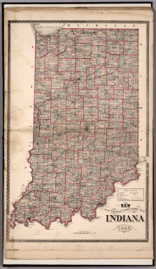
1882 Sectional and Township Map of Indiana. 1 … County Atlas Sectional and Township Map of Indiana. 1 … |

1882 New Railroad Map of the United States. County Atlas New Railroad Map of the United States. |

1882 Western Hemisphere. Eastern Hemisphere. County Atlas Western Hemisphere. Eastern Hemisphere. |

1897 Saint Croix County, Wisconsin County Atlas Outline Map of Saint Croix County, Wisco … |

1897 Cady, Saint Croix County, Wisconsin. County Atlas Plat of Cady. |

1897 Springfield, Saint Croix County, Wiscons … County Atlas Plat of Springfield. |

1897 Glenwood, Saint Croix County, Wisconsin. County Atlas Plat of Glenwood. |

1897 Forest, Saint Croix County, Wisconsin. County Atlas Plat of Forest. |

1897 Eau Galle, Saint Croix County, Wisconsin … County Atlas Plat of Eau Galle. |

1897 Baldwin, Saint Croix County, Wisconsin. County Atlas Plat of Baldwin. |

1897 Emerald, Saint Croix County, Wisconsin. County Atlas Plat of Emerald. |

1897 Cylon, Saint Croix County, Wisconsin. County Atlas Plat of Cylon. |

1897 Pleasant Valley. Rush River, Saint Croix … County Atlas (Plat of) Pleasant Valley. (Plat of) Rus … |

1897 Hammond, Saint Croix County, Wisconsin. County Atlas Plat of Hammond. |

1897 Erin, Saint Croix County, Wisconsin. County Atlas Plat of Erin. |

1897 Stanton, Saint Croix County, Wisconsin. County Atlas Plat of Stanton. |

1897 Kinnickinnic, Saint Croix County, Wiscon … County Atlas Plat of Kinnickinnic. |