Browse All

1922 Warm Season Evaporation. Atlas of Americ … National Atlas Warm Season Evaporation in Inches. Atlas … |

1884 (Mapa de la Republica de Chile 8) National Atlas (Mapa de la Republica de Chile. 8. Desde … |

1935 Areas of Soil Surveys. Atlas of American … National Atlas Areas Covered by the Soil Survey. Soils, … |
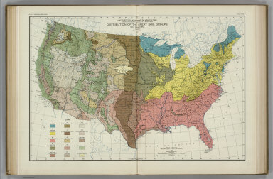
1931 Great Soil Groups. Atlas of American Agr … National Atlas Distribution of the Great Soil Groups. S … |

1884 (Mapa de la Republica de Chile 9) National Atlas (Mapa de la Republica de Chile. 9. Desde … |

1931 Parent Materials of Soils. Atlas of Amer … National Atlas Distribution of Parent Materials of Soil … |

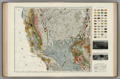
1931 Soil Map of the United States, Section 1 … National Atlas Soil Map of the United States by Curtis … |

1884 (Mapa de la Republica de Chile 10) National Atlas (Mapa de la Republica de Chile. 10. Desd … |

1931 Soils without Normal Profiles. Atlas of … National Atlas Distribution of Soils without Normal Pro … |

1936 Clarke County, Georgia, Soils. Atlas of … National Atlas Soils Map. Clarke County, Georgia. Soils … |

1884 (Mapa de la Republica de Chile 11) National Atlas (Mapa de la Republica de Chile. 11. Desd … |

1923 Natural Vegetation. Atlas of American Ag … National Atlas Natural Vegetation. Grassland and Desert … |

1924 Grassland Divisions. Land in Crops, 1919 … National Atlas Grassland Divisions. Land in Crops, 1919 … |

1884 (Mapa de la Republica de Chile 13) National Atlas (Mapa de la Republica de Chile. 13. Desd … |

1928 Monthly Temperature Maps: March. April. … National Atlas (Monthly Temperature Maps:) March. April … |

1928 Monthly Temperature Maps: May. June. Atl … National Atlas (Monthly Temperature Maps:) May. June. A … |

1928 Monthly Temperature Maps: July. August. … National Atlas (Monthly Temperature Maps:) July. August … |

1928 Monthly Temperature Maps: September. Oct … National Atlas (Monthly Temperature Maps:) September. O … |

1928 Monthly Temperature Maps: November. Dece … National Atlas (Monthly Temperature Maps:) November. De … |

1916 Location of Meteorological Stations. Atl … National Atlas Location of Meteorological Stations. Fig … |

1884 (Mapa de la Republica de Chile 14) National Atlas (Mapa de la Republica de Chile. 14. Desd … |

1922 Monthly (May, June, July) Precipitation. … National Atlas Average Monthly (May, June, July) Precip … |

1931 Soil Map of the United States, Section 2 … National Atlas Soil Map of the United States by Curtis … |

1884 (Mapa de la Republica de Chile 15) National Atlas (Mapa de la Republica de Chile. 15. Desd … |

1931 Soil Map of the United States, Section 3 … National Atlas Soil Map of the United States by Curtis … |

1931 Soil Map of the United States, Section 4 … National Atlas Soil Map of the United States by Curtis … |
1931 Soil Map of the United States, Section 5 … National Atlas Soil Map of the United States by Curtis … |

1931 Soil Map of the United States, Section 6 … National Atlas Soil Map of the United States by Curtis … |

1860 Map Of Mexico, Central America, And The … World Atlas Map Of Mexico, Central America, And The … |

1931 Soil Map of the United States, Section 7 … National Atlas Soil Map of the United States by Curtis … |

1931 Soil Map of the United States, Section 8 … National Atlas Soil Map of the United States by Curtis … |

1931 Soil Map of the United States, Section 9 … National Atlas Soil Map of the United States by Curtis … |

1931 Soil Map of the United States, Section 1 … National Atlas Soil Map of the United States by Curtis … |

1931 Soil Map of the United States, Section 1 … National Atlas Soil Map of the United States by Curtis … |

1931 Soil Map of the United States, Section 1 … National Atlas Soil Map of the United States by Curtis … |

1897 Area and population of the world 1890. World Atlas The population of the world, 1890. Rand, … |

1897 World, Mercator's projection. World Atlas Rand, McNally & Co.'s. indexed atlas of … |

1897 W., E. hemispheres World Atlas Rand, McNally & Company's indexed atlas … |

1897 North Polar regions. World Atlas Rand, McNally & Company's indexed atlas … |

1874 Mountains & Rivers. World Atlas Mountains & Rivers. |

1874 Climatological Map of the United States. World Atlas Gray's Atlas Climatological Map of the U … |

1874 Botanical Divisions of the United States … World Atlas Map of the United States Showing the Pri … |

1874 Zoological Divisions of the United State … World Atlas Map of the United States Showing the Pri … |

1874 Geological Formations of the United Stat … World Atlas Gray's Atlas Map of the United States Sh … |

1897 Europe. World Atlas Rand, McNally & Company's indexed atlas … |

1860 Map of South America. World Atlas Map Of South America, Showing Its Politi … |

1874 Western and Eastern Hemisphere. World Atlas Western Hemisphere. Eastern Hemisphere. |

1874 Asia. World Atlas Gray's Atlas Map of Asia. |

1873 Oceanica. World Atlas Gray's Atlas Map of Oceanica, 1873. |

1897 England, Wales. World Atlas Rand, McNally & Company's indexed atlas … |