Who What Where WhenREMOVEWHAT
|
Author
Tanner, Henry S.
Full Title
The Countries Traveled by the Apostles. Published by H.S. Tanner, Philadelphia. (1826)
Publisher
H.S. Tanner
Author
Tanner, Henry S.
Full Title
Patriarchati Orientales. Published by H.S. Tanner, Philadelphia. (1826)
Publisher
H.S. Tanner
Author
Tanner, Henry S.
Full Title
Patriarchatus Occidentalis. Published by H.S. Tanner, Philadelphia. (1826)
Publisher
H.S. Tanner
Author
Tanner, Henry S.
Full Title
Terra Veteribus, Nota. Published by H.S. Tanner, Philadelphia. (1826)
Publisher
H.S. Tanner
Author
Pinkerton, John, 1758-1826
Full Title
Turkey in Asia. Drawn under the direction of Mr. Pinkerton by L. Hebert. Neele sculpt. 352 Strand. London: published Sepr. 1st. 1813, by Cadell & Davies, Strand & Longman, Hurst, Rees, Orme, & Brown, Paternoster Row.
Publisher
[Cadell and Davies, Longman, Hurst, Rees, Orme, and Brown]
Author
Wheeler, G.M.
Full Title
Land Classification Map Of Part Of S.W. California, Atlas Sheet No. 73 (C.). Issued Febr'y 23d 1881. Weyss, Nell & Rock, Del. Expeditions of 1875 & 1878 Under the Command of 1st. Lieut. Geo. M. Wheeler, Corps of Engineers, U.S. Army. U.S. Geographical Surveys West Of The 100th Meridian.
Publisher
U.S.
Author
Tanner, Henry S.
Full Title
Aegyptus. Published by H.S. Tanner, Philadelphia. (1826)
Publisher
H.S. Tanner
Author
Tanner, Henry S.
Full Title
Africa Antiqua. Published by H.S. Tanner, Philadelphia. (1826)
Publisher
H.S. Tanner
Author
Tanner, Henry S.
Full Title
Hispania Antiqua. Published by H.S. Tanner, Philadelphia. (1826)
Publisher
H.S. Tanner
Author
Tanner, Henry S.
Full Title
Gallia Antiqua. Published by H.S. Tanner, Philadelphia. (1826)
Publisher
H.S. Tanner
Author
Tanner, Henry S.
Full Title
Italia Antiqua. Published by H.S. Tanner, Philadelphia. (1826)
Publisher
H.S. Tanner
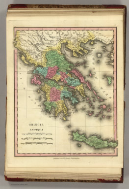
Author
Tanner, Henry S.
Full Title
Graecia Antiqua. Published by H.S. Tanner, Philadelphia. (1826)
Publisher
H.S. Tanner
Author
Tanner, Henry S.
Full Title
Graecia Pars Septentrionalis aliter Macedonia, Thessalia & Epirus cum Traci.. Published by H.S. Tanner, Philadelphia. (1826)
Publisher
H.S. Tanner
Author
Tanner, Henry S.
Full Title
Germania Antiqua. Published by H.S. Tanner, Philadelphia. (1826)
Publisher
H.S. Tanner
Author
Tanner, Henry S.
Full Title
Brittannicae Insule ex Aevi Romani Monumentis. Published by H.S. Tanner, Philadelphia. (1826)
Publisher
H.S. Tanner
Author
Tanner, Henry S.
Full Title
Palestina seu Terra Sancta. Published by H.S. Tanner, Philadelphia. (1826)
Publisher
H.S. Tanner
Author
Pinkerton, John, 1758-1826
Full Title
China. Drawn under the direction of Mr. Pinkerton by L. Hebert. Neele sculpt. 352 Strand. London: published 2d. March 1811 by Cadell & Davies, Strand & Longman, Hurst, Rees, Orme, & Brown, Pater Noster Row.
Publisher
[Cadell and Davies, Longman, Hurst, Rees, Orme, and Brown]
Full Title
Western Hemisphere. Copyright 1886 by Wm. M. Bradley & Bro.
Publisher
Wm. M. Bradley & Bro.
Full Title
Eastern Hemisphere. Copyright 1886 by Wm. M. Bradley & Bro.
Publisher
Wm. M. Bradley & Bro.
Full Title
Map of the World on the Mercator projection, exhibiting the American Continent as its centre. Copyright 1886 by Wm. M. Bradley & Bro.
Publisher
Wm. M. Bradley & Bro.
Full Title
Map of North America. Showing its political divisions, and recent discoveries in the Polar Regions. Copyright 1886 by Wm. M. Bradley & Bro.
Publisher
Wm. M. Bradley & Bro.
Full Title
County map of Nova Scotia, New Brunswick, Cape Breton Id. and Pr. Edward's Id. (with) City and harbor of Halifax. Copyright 1886 by Wm. M. Bradley & Bro.
Publisher
Wm. M. Bradley & Bro.
Author
Pinkerton, John, 1758-1826
Full Title
Japan. Drawn under the direction of Mr. Pinkerton by L. Hebert. Neele sculpt. 352 Strand. London: published 1st. March 1809, by Cadell & Davies, Strand & Longman, Hurst, Rees, Orme, & Brown, Paternoster Row.
Publisher
[Cadell and Davies, Longman, Hurst, Rees, Orme, and Brown]
Full Title
Map of Ontario in counties. (with) Manitoba, Dominion of Canada. Copyright 1886 by Wm. M. Bradley & Bro.
Publisher
Wm. M. Bradley & Bro.
Full Title
Map of Quebec in counties. (with) Environs of Montreal. Copyright 1886 by Wm. M. Bradley & Bro.
Publisher
Wm. M. Bradley & Bro.
Full Title
Railroad map of the United States, showing the through lines of communication from the Atlantic to the Pacific, together with the various steamship lines along the seaboard. W. H. Gamble, Sc. Copyright 1886 by Wm. M. Bradley & Bro.
Publisher
Wm. M. Bradley & Bro.
Full Title
Map of the United States, and territories. Together with Canada &c. (with) Island of Newfoundland. W. H. Gamble, Sc. Copyright 1886 by Wm. M. Bradley & Bro.
Publisher
Wm. M. Bradley & Bro.
Full Title
County and township map of the state of Maine. Copyright 1886 by Wm. M. Bradley & Bro. W. H. Gamble, Sc. Phila.
Publisher
Wm. M. Bradley & Bro.
Full Title
County and township map of Vermont and New Hampshire. Copyright 1886 by Wm. M. Bradley & Bro.
Publisher
Wm. M. Bradley & Bro.
Full Title
County and township map of the states of Massachusetts, Connecticut and Rhode Island. Drawn and engraved by W.H. Gamble, Philadelphia. Copyright 1886 by Wm. M. Bradley & Bro.
Publisher
Wm. M. Bradley & Bro.
Full Title
Plan of Boston. (with) Map of the country around Boston showing also its harbor & islands. Copyright 1886 by Wm. M. Bradley & Bro.
Publisher
Wm. M. Bradley & Bro.
Full Title
County map of the state of New York. (with) Map of New York City and vicinity. (with) Albany. (with) Rochester. (with) Buffalo. (with) Troy, West Troy. Drawn and engraved by W.H. Gamble, Philadelphia. Copyright 1886 by Wm. M. Bradley & Bro.
Publisher
Wm. M. Bradley & Bro.
Full Title
New York and Brooklyn. Copyright 1886 by Wm. M. Bradley & Bro.
Publisher
Wm. M. Bradley & Bro.
Author
Pinkerton, John, 1758-1826
Full Title
Hindostan. Drawn under the direction of Mr. Pinkerton by L. Hebert. Neele sculpt. 352 Strand. London: published 2d. March 1811 by Cadell & Davies, Strand & Longman, Hurst, Rees, Orme, & Brown, Pater Noster Row.
Publisher
[Cadell and Davies, Longman, Hurst, Rees, Orme, and Brown]
Full Title
County map of the state of New Jersey. Copyright 1886 by Wm. M. Bradley & Bro.
Publisher
Wm. M. Bradley & Bro.
Full Title
County map of Pennsylvania. Copyright 1886 by Wm. M. Bradley & Bro.
Publisher
Wm. M. Bradley & Bro.
Full Title
Harrisburg. Williamsport. Erie. Scranton. (Copyright 1886 by Wm. M. Bradley & Bro.)
Publisher
Wm. M. Bradley & Bro.
Full Title
Plan of the city of Philadelphia and Camden. Drawn and engraved by W.H. Gamble. Copyright 1886 by Wm. M. Bradley & Bro.
Publisher
Wm. M. Bradley & Bro.
Full Title
Plan of Baltimore. Copyright 1886 by Wm. M. Bradley & Bro.
Publisher
Wm. M. Bradley & Bro.
Full Title
County map of the states of Delaware, Maryland, Virginia and West Virginia. Copyright 1886 by Wm. M. Bradley & Bro.
Publisher
Wm. M. Bradley & Bro.
Full Title
Plan of the city of Washington. The capitol of the United States of America. Drawn and engraved by W.H. Gamble, Sc. Phila. (Copyright 1886 by Wm. M. Bradley & Bro.)
Publisher
Wm. M. Bradley & Bro.
Full Title
County map of Kentucky and Tennessee. Copyright 1886 by Wm. M. Bradley & Bro.
Publisher
Wm. M. Bradley & Bro.
Full Title
County map of the states of Georgia and Alabama. (with) Savannah, Georgia. (with) City of Atlanta, the capitol of Georgia. Copyright 1886 by Wm. M. Bradley & Bro.
Publisher
Wm. M. Bradley & Bro.
Full Title
North and South Carolina. (with) Plan of Charleston. (with) Map of Charleston Harbor. Copyright 1886 by Wm. M. Bradley & Bro.
Publisher
Wm. M. Bradley & Bro.
Author
Pinkerton, John, 1758-1826
Full Title
Persia. Drawn under the direction of Mr. Pinkerton by L. Hebert. Neele sculpt. 352 Strand. London: published 1st. Septr. 1811 by Cadell & Davies, Strand & Longman, Hurst, Rees, Orme, & Brown, Pater Noster Row.
Publisher
[Cadell and Davies, Longman, Hurst, Rees, Orme, and Brown]
Full Title
County map of Florida. Copyright 1886 by Wm. M. Bradley & Bro.
Publisher
Wm. M. Bradley & Bro.
Full Title
County map of the states of Arkansas, Mississippi and Louisiana. Copyright 1886 by Wm. M. Bradley & Bro.
Publisher
Wm. M. Bradley & Bro.
Full Title
Plan of New Orleans. Copyright 1886 by Wm. M. Bradley & Bro.
Publisher
Wm. M. Bradley & Bro.
Full Title
County map of the state of Texas. Showing also portions of the adjoining states and territories. (with) Plan of Galveston and vicinity. Copyright 1886 by Wm. M. Bradley & Bro.
Publisher
Wm. M. Bradley & Bro.
|