Who What Where WhenREMOVEWHAT
|
Author
Moll, Herman, d. 1732
Full Title
Florida called by ye French Louisiana &c. By H. Moll Geographer. (Printed and sold by Tho: Bowles next ye Chapter House in St. Pauls Church Yard, & Ino: Bowles at ye Black Horse in Cornhill, 1736?)
Publisher
Thos. Bowles and John Bowles
Author
Viele, Egbert L.
Full Title
Topographical Atlas Of The City Of New York Including The Annexed Territory. IV. (Next to northernmost portion). Showing original water courses and made land. Prepared Under The Direction Of Egbert L. Viele, Civil and Topographical Engineer. 234 Broadway, N.Y. 1874. Eugene Quackenbush, C.E. Entered ... 1874, by Egbert L. Viele in the Office of the Librarian of Congress. Julius Bien, Photo Lith.
Publisher
E.L. Viele
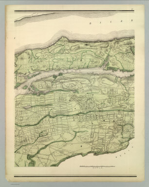
Author
Viele, Egbert L.
Full Title
Topographical Atlas Of The City Of New York Including The Annexed Territory. V. (Northernmost portion). Showing original water courses and made land. Prepared Under The Direction Of Egbert L. Viele, Civil and Topographical Engineer. 234 Broadway, N.Y. 1874. Eugene Quackenbush, C.E. Entered ... 1874, by Egbert L. Viele in the Office of the Librarian of Congress. Julius Bien, Photo Lith.
Publisher
E.L. Viele
Author
Johnston, W. & A.K.
Full Title
(Frontispiece) North Pole Chart. Feb. 1912. Engraved, Printed and Published by W. & A.K. Johnston, Limited, Edinburgh & London. Frontispiece.
Publisher
W.& A.K. Johnston
Author
Moll, Herman, d. 1732
Full Title
A map of the West-Indies &c., Mexico or New Spain. Also ye trade winds, and ye several tracts made by ye Galeons and Flota from place to place. By H. Moll Geographer. (Printed and sold by Tho: Bowles next ye Chapter House in St. Pauls Church Yard, & Ino: Bowles at ye Black Horse in Cornhill, 1736?)
Publisher
Thos. Bowles and John Bowles
Author
Johnston, W. & A.K.
Full Title
(Frontispiece) South Pole Chart. Mar. 1911. Engraved, Printed and Published by W. & A.K. Johnston, Limited, Edinburgh & London. Frontispiece.
Publisher
W.& A.K. Johnston
Author
Johnston, W. & A.K.
Full Title
The World in Hemispheres. Western Hemisphere. Eastern Hemisphere. Keith Johnston's General Atlas. Engraved, Printed, and Published by W. & A.K. Johnston, Limited, Edinburgh & London.
Publisher
W.& A.K. Johnston
Author
Johnston, W. & A.K.
Full Title
Chart of the World on Mercators Projection. Showing the direction of the ocean currents, with the routes and distances between principal ports. Jan. 1911. Keith Johnston's General Atlas. Engraved, Printed, and Published by W. & A.K. Johnston, Limited, Edinburgh & London.
Publisher
W.& A.K. Johnston
Author
Johnston, W. & A.K.
Full Title
Basin of the North Atlantic Ocean. (with) Gulf of Mexico. May 1912. Engraved, Printed, and Published by W. & A.K. Johnston, Limited, Edinburgh & London.
Publisher
W.& A.K. Johnston
Author
Johnston, W. & A.K.
Full Title
Europe. Keith Johnston's General Atlas. Nov. 1910. Engraved, Printed, and Published by W. & A.K. Johnston, Limited, Edinburgh & London.
Publisher
W.& A.K. Johnston
Author
Johnston, W. & A.K.
Full Title
The British Isles (Political). (with) Shetland Islands. (with) Channel Islands. (with) London Metropolitan Boroughs. Keith Johnston's General Atlas. May 1911. Engraved, Printed, and Published by W. & A.K. Johnston, Limited, Edinburgh & London.
Publisher
W.& A.K. Johnston
Author
Johnston, W. & A.K.
Full Title
England and Wales (northern sheet). Keith Johnston's General Atlas. Aug. 1910. Engraved, Printed, and Published by W. & A.K. Johnston, Limited, Edinburgh & London.
Publisher
W.& A.K. Johnston
Author
Johnston, W. & A.K.
Full Title
England and Wales (southern sheet). (with) Scilly Islands and Lands End. (with) Environs of London. Keith Johnston's General Atlas. Aug. 1910. Engraved, Printed, and Published by W. & A.K. Johnston, Limited, Edinburgh & London.
Publisher
W.& A.K. Johnston
Author
Johnston, W. & A.K.
Full Title
Scotland (northern sheet). (with) Shetland Islands. (with) Fair I. (with) Foula I. Keith Johnston's General Atlas. Feb, 1911. Engraved, Printed, and Published by W. & A.K. Johnston, Limited, Edinburgh & London.
Publisher
W.& A.K. Johnston
Author
Moll, Herman, d. 1732
Full Title
The island of Jamaica divided into its principal parishes with the roads &c. By H. Moll Geographer. (Printed and sold by Tho: Bowles next ye Chapter House in St. Pauls Church Yard, & Ino: Bowles at ye Black Horse in Cornhill, 1736?)
Publisher
Thos. Bowles and John Bowles
Author
Johnston, W. & A.K.
Full Title
Scotland (southern sheet). (with) Edinburgh. Keith Johnston's General Atlas. Feb. 1911. Engraved, Printed, and Published by W. & A.K. Johnston, Limited, Edinburgh & London.
Publisher
W.& A.K. Johnston
Author
Johnston, W. & A.K.
Full Title
Ireland. (with) Dublin. Keith Johnston's General Atlas. Feb. 1911. Engraved, Printed, and Published by W. & A.K. Johnston, Limited, Edinburgh & London.
Publisher
W.& A.K. Johnston
Author
Johnston, W. & A.K.
Full Title
France in Departments. (with) France in Provinces. (with) Part of the Riviera from Cannes to Menton. (with) Corse. Keith Johnston's General Atlas. Sept. 1911. Engraved, Printed, and Published by W. & A.K. Johnston, Limited, Edinburgh & London.
Publisher
W.& A.K. Johnston
Author
Johnston, W. & A.K.
Full Title
Spain & Portugal. (with) Canary Islands. (with) Madeira. (with) Lisbon. (with) Madrid. Keith Johnston's General Atlas. May, 1911. Engraved, Printed, and Published by W. & A.K. Johnston, Limited, Edinburgh & London.
Publisher
W.& A.K. Johnston
Author
Johnston, W. & A.K.
Full Title
Switzerland and the Alps of Savoy & Piedmont. (with) Geneva and its Environs. Keith Johnston's General Atlas. Jan. 1912. Engraved, Printed, and Published by W. & A.K. Johnston, Limited, Edinburgh & London.
Publisher
W.& A.K. Johnston
Author
Johnston, W. & A.K.
Full Title
North & Central Italy and the Island of Corsica. (with) Environs of Rome. Keith Johnston's General Atlas. Sept. 1911. Engraved, Printed, and Published by W. & A.K. Johnston, Limited, Edinburgh & London.
Publisher
W.& A.K. Johnston
Author
Johnston, W. & A.K.
Full Title
South Italy and the Island of Sardinia. (with) Naples and Capri. Keith Johnston's General Atlas. Sept. 1911. Engraved, Printed, and Published by W. & A.K. Johnston, Limited, Edinburgh & London.
Publisher
W.& A.K. Johnston
Author
Johnston, W. & A.K.
Full Title
Basin of the Mediterranean. (with) Strait of Gibralter. (with) Maltese Islands. (with) Valetta. (with) Venice. (with) Alexandria. Keith Johnston's General Atlas. Feb. 1911. Engraved, Printed, and Published by W. & A.K. Johnston, Limited, Edinburgh & London.
Publisher
W.& A.K. Johnston
Author
Johnston, W. & A.K.
Full Title
Greece. (with) The Cyclades. (with) Corcyra or Corfu. Keith Johnston's General Atlas. Oct. 1911. Engraved, Printed, and Published by W. & A.K. Johnston, Limited, Edinburgh & London.
Publisher
W.& A.K. Johnston
Author
Moll, Herman, d. 1732
Full Title
The island of St. Christophers, alias St. Kitts. By H. Moll Geographer. (Printed and sold by Tho: Bowles next ye Chapter House in St. Pauls Church Yard, & Ino: Bowles at ye Black Horse in Cornhill, 1736?)
Publisher
Thos. Bowles and John Bowles
Author
Johnston, W. & A.K.
Full Title
Turkey in Europe with Bulgaria also Rumania, Servia & Montenegro. (with) The Bosporus & Constantinople. (with) Crete or Candia. Keith Johnston's General Atlas. Oct. 1911. Engraved, Printed, and Published by W. & A.K. Johnston, Limited, Edinburgh & London.
Publisher
W.& A.K. Johnston
Author
Johnston, W. & A.K.
Full Title
Austria & Hungary (eastern sheet). Keith Johnston's General Atlas. Apr. 1912. Printed, and Published by W. & A.K. Johnston, Limited, Edinburgh & London.
Publisher
W.& A.K. Johnston
Author
Johnston, W. & A.K.
Full Title
Austria & Hungary (western sheet). (with) Vienna. (with) Continuation of Dalmatia & Herzegovina. Keith Johnston's General Atlas. Apr. 1912. Engraved, Printed, and Published by W. & A.K. Johnston, Limited, Edinburgh & London.
Publisher
W.& A.K. Johnston
Author
Johnston, W. & A.K.
Full Title
Empire of Germany (northern portion). (with) Environs of Berlin & Potsdam. The Kingdom of Prussia is Coloured Red. Keith Johnston's General Atlas. June 1910. Engraved, Printed, and Published by W. & A.K. Johnston, Limited, Edinburgh & London.
Publisher
W.& A.K. Johnston
Author
Johnston, W. & A.K.
Full Title
Empire of Germany (southern portion). (with) Frankfurt. (with) Munich. Keith Johnston's General Atlas. Feb. 1912. Engraved, Printed, and Published by W. & A.K. Johnston, Limited, Edinburgh & London.
Publisher
W.& A.K. Johnston
Author
Johnston, W. & A.K.
Full Title
Belgium and the Netherlands. (with) Amsterdam. (with) Brussels. Keith Johnston's General Atlas. Aug. 1911. Engraved, Printed, and Published by W. & A.K. Johnston, Limited, Edinburgh & London.
Publisher
W.& A.K. Johnston
Author
Johnston, W. & A.K.
Full Title
Denmark with Northwest portion of the German Empire. ... (with) Island of Iceland. (with) Copenhagen. (with) (Environs of) Copenhagen. (with) Faroe Islands. (with) Bornholm. (with) The Elbe from Hamburg to Cuxhaven). (with) Kaiser Wilhelm Canal. Keith Johnston's General Atlas. Oct. 1911. Engraved, Printed, and Published by W. & A.K. Johnston, Limited, Edinburgh & London.
Publisher
W.& A.K. Johnston
Author
Johnston, W. & A.K.
Full Title
Sweden & Norway (Scandanavia). (with) Stockholm and its environs. (with) Christiania. Keith Johnston's General Atlas. Dec. 1911. Engraved, Printed, and Published by W. & A.K. Johnston, Limited, Edinburgh & London.
Publisher
W.& A.K. Johnston
Author
Johnston, W. & A.K.
Full Title
Basin of the Baltic. (with) St. Peterburg and its environs. (with) Danzig. (with) Stettin. (with) Kiel. Keith Johnston's General Atlas. Sept. 1911. Engraved, Printed, and Published by W. & A.K. Johnston, Limited, Edinburgh & London.
Publisher
W.& A.K. Johnston
Author
Moll, Herman, d. 1732
Full Title
The island of Antego. By H. Moll Geographer. Sold by T. Bowles next ye Chapter House in St. Pauls Church yard, & I. Bowles at the Black Horse in Cornhill, (1736?)
Publisher
Thos. Bowles and John Bowles
Author
Johnston, W. & A.K.
Full Title
European Russia. (with) Moscow. Keith Johnston's General Atlas. Jan. 1910. Engraved, Printed, and Published by W. & A.K. Johnston, Limited, Edinburgh & London.
Publisher
W.& A.K. Johnston
Author
Johnston, W. & A.K.
Full Title
South-West Russia. (with) Odessa. Showing the Extent of the Kingdom of Poland prior to its partition in 1772. Keith Johnston's General Atlas. May 1912. Engraved, Printed, and Published by W. & A.K. Johnston, Limited, Edinburgh & London.
Publisher
W.& A.K. Johnston
Author
Johnston, W. & A.K.
Full Title
Asia. Keith Johnston's General Atlas. Aug. 1911. Engraved, Printed, and Published by W. & A.K. Johnston, Limited, Edinburgh & London.
Publisher
W.& A.K. Johnston
Author
Johnston, W. & A.K.
Full Title
Turkey in Asia (Asia Minor) and Transcaucasia. Keith Johnston's General Atlas. Oct. 1911. Engraved, Printed, and Published by W. & A.K. Johnston, Limited, Edinburgh & London.
Publisher
W.& A.K. Johnston
Author
Johnston, W. & A.K.
Full Title
Palestine. Keith Johnston's General Atlas. Oct. 1911. Engraved, Printed, and Published by W. & A.K. Johnston, Limited, Edinburgh & London.
Publisher
W.& A.K. Johnston
Author
Johnston, W. & A.K.
Full Title
Persia and Afghanistan. Keith Johnston's General Atlas. Apr. 1912. Engraved, Printed, and Published by W. & A.K. Johnston, Limited, Edinburgh & London.
Publisher
W.& A.K. Johnston
Author
Johnston, W. & A.K.
Full Title
Central Asia. Keith Johnston's General Atlas. Jan. 1912. Engraved, Printed, and Published by W. & A.K. Johnston, Limited, Edinburgh & London.
Publisher
W.& A.K. Johnston
Author
Johnston, W. & A.K.
Full Title
India (northern sheet). Keith Johnston's General Atlas. May 1911. Engraved, Printed, and Published by W. & A.K. Johnston, Limited, Edinburgh & London.
Publisher
W.& A.K. Johnston
Author
Johnston, W. & A.K.
Full Title
South Africa. (with) The Cape. (with) Cape Town. (with) Durban and Port Natal. Keith Johnston's General Atlas. May 1912. Engraved, Printed, and Published by W. & A.K. Johnston, Limited, Edinburgh & London.
Publisher
W.& A.K. Johnston
Author
Johnston, W. & A.K.
Full Title
North America. Keith Johnston's General Atlas. Apr. 1912. Engraved, Printed, and Published by W. & A.K. Johnston, Limited, Edinburgh & London.
Publisher
W.& A.K. Johnston
Author
Moll, Herman, d. 1732
Full Title
The island of Barbadoes. Divided into its parishes, with the roads, paths, &c. According to an actual and accurate survey. By H. Moll Geographer. Printed and sold by Tho: Bowles next ye Chapter House in St. Pauls Church yard, & I. Bowles at the Black Horse in Cornhill, (1736?)
Publisher
Thos. Bowles and John Bowles
Author
Johnston, W. & A.K.
Full Title
Dominion of Canada (Eastern Sheet) Comprising New Brunswick, Nova Scotia, Prince Edward Island with Inset of Newfoundland. Keith Johnston's General Atlas. Apr. 1912. Engraved, Printed, and Published by W. & A.K. Johnston, Limited, Edinburgh & London.
Publisher
W.& A.K. Johnston
Author
Johnston, W. & A.K.
Full Title
Dominion of Canada (Central Sheet). (with) Niagara and Vicinity. (with) Montreal. (with) Quebec. Keith Johnston's General Atlas. Jan. 1912. Engraved, Printed, and Published by W. & A.K. Johnston, Limited, Edinburgh & London.
Publisher
W.& A.K. Johnston
Author
Johnston, W. & A.K.
Full Title
Dominion of Canada (Western Sheet) Comprising Manitoba, British Columbia and the North-West Territory. Keith Johnston's General Atlas. Apr. 1912. Engraved, Printed, and Published by W. & A.K. Johnston, Limited, Edinburgh & London.
Publisher
W.& A.K. Johnston
Author
Johnston, W. & A.K.
Full Title
United States of North America (North East Sheet). Keith Johnston's General Atlas. Feb. 1912. Engraved, Printed, and Published by W. & A.K. Johnston, Limited, Edinburgh & London.
Publisher
W.& A.K. Johnston
|