Browse All

1797 St. Diego, St. Blas. [Chart Atlas, World Atlas] Plan du Port de St. Diego en Californie … |

1858 Asia (Southern sheet). World Atlas Asia (Southern sheet). |

1846 Africa. World Atlas Africa By H.S. Tanner. (with) two inset … |

1791 Sphere de Ptolomee. World Atlas Sphere de Ptolomee. Bonne del. (A Paris, … |

1858 Asia (Eastern Sheet). World Atlas Asia (Eastern Sheet). |

1782 Mappe-monde. World Atlas Mappe-monde ou description du globe terr … |

1858 Africa (physical). World Atlas Africa (physical). |

1858 Africa (political). World Atlas Africa (political). (inset) Liberia. (in … |

1782 L'Europe. World Atlas L'Europe divisee en ses principaux etats … |

1791 La France, departemens. World Atlas La France divisee en 83. departemens sui … |

1858 Oceanica, Australia, New Zealand. World Atlas Oceanica. Australia, New Zealand. (inset … |

1786 France, carte generale. World Atlas Carte generale de France divisee par gou … |

1858 Roman Empire. World Atlas Roman Empire, Imperium Romanorum, Latiss … |

1785 Flandre francoise, Artois, Picardie, Bou … World Atlas Carte des gouvernements de Flandre Franc … |

1791 Normandie, Maine, Perche. World Atlas Carte des gouvernements de Normandie ave … |

1746 America Septentrionalis. A Map of the Br … National Atlas America Septentrionalis. A Map of the Br … |

1746 A Map of the British Empire in America. … National Atlas A Map of the British Empire in America w … |

1746 A Map of the British Empire in America. … National Atlas A Map of the British Empire in America w … |

1786 Bretagne. World Atlas Carte du Gouvernement de Bretagne. Assuj … |

1746 A Map of the British Empire in America. … National Atlas A Map of the British Empire in America w … |

1746 A Map of the British Empire in America. … National Atlas A Map of the British Empire in America w … |

1746 A Map of the British Empire in America. … National Atlas A Map of the British Empire in America w … |

1746 A Map of the British Empire in America. … National Atlas A Map of the British Empire in America w … |

1762 Suede, Danemarck et Norwege. World Atlas Les Couronnes du Nord comprenant les roy … |

1746 A Map of the British Empire in America. … National Atlas A Map of the British Empire in America w … |

1746 A Map of the British Empire in America. … National Atlas A Map of the British Empire in America w … |

1746 A Map of the British Empire in America. … National Atlas A Map of the British Empire in America w … |

1746 A Map of the British Empire in America. … National Atlas A Map of the British Empire in America w … |

1785 Russie occidentale. World Atlas Partie Occidentale de l'Empire de Russie … |

1846 Egypt. World Atlas Egypt. (with) Nubia. |

1746 A Map of the British Empire in America. … National Atlas A Map of the British Empire in America w … |

1746 A Map of the British Empire in America. … National Atlas A Map of the British Empire in America w … |

1746 A Map of the British Empire in America. … National Atlas A Map of the British Empire in America w … |

1746 A Map of the British Empire in America. … National Atlas A Map of the British Empire in America w … |

1746 A Map of the British Empire in America. … National Atlas A Map of the British Empire in America w … |

1785 Russie orientale. World Atlas Partie Orientale de l'Empire de Russie, … |

1746 A Map of the British Empire in America. … National Atlas A Map of the British Empire in America w … |

1746 A Map of the British Empire in America. … National Atlas A Map of the British Empire in America w … |

1746 A Map of the British Empire in America. … National Atlas A Map of the British Empire in America w … |

1785 Composite: Russie. World Atlas (Composite of) Partie ... l'Empire de Ru … |

1746 A Map of the British Empire in America. … National Atlas A Map of the British Empire in America w … |

1746 A Map of the British Empire in America. … National Atlas A Map of the British Empire in America w … |

1780 Turquie. World Atlas Turquie d'Europe et partie de celle d'As … |

1780 L'Asie. World Atlas L'Asie, divisee en ses principaux etats … |

1791 Turquie d'Asie. World Atlas Carte de la Turquie d'Asie. Presque enti … |

1814 State of Ohio. World Atlas The State of Ohio with part of Upper Can … |

1832 World, Mercators projection. World Atlas The World, on Mercators projection by J. … |

1785 Arabie. World Atlas Carte de l'Arabie qui se divise en Arabi … |
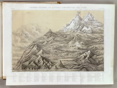
1865 Cuadro general de alturas comparativas d … National Atlas Cuadro general de alturas comparativas d … |

1865 Temblores en Arequipa; Cortes vertical, … National Atlas Linea que representa los temblores senti … |