Who What Where WhenREMOVEWHO
WHEN
|
Author
Sanborn-Perris Map Company, Limited
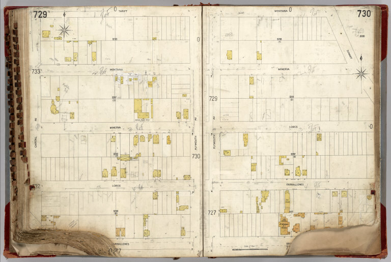
Full Title
(Vol. 6, Page 729-730. San Francisco Sanborn Insurance Maps.)
Publisher
Sanborn-Perris Map Company, Limited
Author
Sanborn-Perris Map Company, Limited
Full Title
(Vol. 6, Page 731-732. San Francisco Sanborn Insurance Maps.)
Publisher
Sanborn-Perris Map Company, Limited
Author
Sanborn-Perris Map Company, Limited
Full Title
(Vol. 6, Page 733-734. San Francisco Sanborn Insurance Maps.)
Publisher
Sanborn-Perris Map Company, Limited
Author
Sanborn-Perris Map Company, Limited
Full Title
(Vol. 6, Page 735-736. San Francisco Sanborn Insurance Maps.)
Publisher
Sanborn-Perris Map Company, Limited
Author
Sanborn-Perris Map Company, Limited
Full Title
(Vol. 6, Page 737-738. San Francisco Sanborn Insurance Maps.)
Publisher
Sanborn-Perris Map Company, Limited
Author
Sanborn-Perris Map Company, Limited
Full Title
(Vol. 6, Page 739-740. San Francisco Sanborn Insurance Maps.)
Publisher
Sanborn-Perris Map Company, Limited
Author
Sanborn-Perris Map Company, Limited
Full Title
(Vol. 6, Page 741-742. San Francisco Sanborn Insurance Maps.)
Publisher
Sanborn-Perris Map Company, Limited
Author
Sanborn-Perris Map Company, Limited
Full Title
(Vol. 6, Page 743-744. San Francisco Sanborn Insurance Maps.)
Publisher
Sanborn-Perris Map Company, Limited
Author
Sanborn-Perris Map Company, Limited
Full Title
(Vol. 6, Page 745-746. San Francisco Sanborn Insurance Maps.)
Publisher
Sanborn-Perris Map Company, Limited
Author
Sanborn-Perris Map Company, Limited
Full Title
Belmont. Scale 200' to 1". March 1900.
Publisher
Sanborn-Perris Map Company, Limited
Author
Thompson & West
Full Title
Map of Livermore, Alameda Co., California. Map of Mission San Jose, Alameda Co., California. (Published by Thompson & West, Oakland, Cala., 1878)
Publisher
Thompson & West
Author
Thompson & West
Full Title
Map of San Leandro, Alameda Co., Cal. (Published by Thompson & West, Oakland, Cala., 1878)
Publisher
Thompson & West
Author
[Fremont, J.C., Preuss, Charles]
Full Title
Topographical Map Of The Road From Missouri To Oregon, Commencing At The Mouth Of The Kansas In The Missouri River And Ending At The Mouth Of The Wallah Wallah In The Columbia. In VII Sections. Section I. From the field notes and journal of Capt. J.C. Fremont, and from sketches and notes made on the ground by his assistant Charles Preuss. Compiled by Charles Preuss, 1846 By order of the Senate of the United States ... Lithogr. by E. Weber & Co. Baltimore ...
Publisher
U.S.
Author
Thompson & West
Full Title
Map of Alvarado, Alameda Co., California. Map of Centreville, Alameda Co. (Published by Thompson & West, Oakland, Cala., 1878)
Publisher
Thompson & West
Author
Thompson & West
Full Title
Map of Washington Corners. Map of Haywards Park Homestead Union, Alameda co., Cal. Niles or Vallejo Mills, Alameda Co., Cal. Map of Pleasanton, Alameda Co., Cal. (Published by Thompson & West, Oakland, Cala., 1878)
Publisher
Thompson & West
Author
[Fremont, J.C., Preuss, Charles]
Full Title
Topographical Map Of The Road From Missouri To Oregon, Commencing At The Mouth Of The Kansas In The Missouri River And Ending At The Mouth Of The Wallah Wallah In The Columbia. In VII Sections. Section II. From the field notes and journal of Capt. J.C. Fremont, and from sketches and notes made on the ground by his assistant Charles Preuss. Compiled by Charles Preuss, 1846 By order of the Senate of the United States ... Lithogr. by E. Weber & Co. Baltimore ...
Publisher
U.S.
Author
[Fremont, J.C., Preuss, Charles]
Full Title
Topographical Map Of The Road From Missouri To Oregon, Commencing At The Mouth Of The Kansas In The Missouri River And Ending At The Mouth Of The Wallah Wallah In The Columbia. In VII Sections. Section III. From the field notes and journal of Capt. J.C. Fremont, and from sketches and notes made on the ground by his assistant Charles Preuss. Compiled by Charles Preuss, 1846 By order of the Senate of the United States ... Lithogr. by E. Weber & Co. Baltimore ...
Publisher
U.S.
Author
[Fremont, J.C., Preuss, Charles]
Full Title
Topographical Map Of The Road From Missouri To Oregon, Commencing At The Mouth Of The Kansas In The Missouri River And Ending At The Mouth Of The Wallah Wallah In The Columbia. In VII Sections. Section IV. From the field notes and journal of Capt. J.C. Fremont, and from sketches and notes made on the ground by his assistant Charles Preuss. Compiled by Charles Preuss, 1846 By order of the Senate of the United States ... Lithogr. by E. Weber & Co. Baltimore ...
Publisher
U.S.
Author
Thompson & West
Full Title
Map of the states of California and Nevada. Published by Thompson & West, 120 Sutter St., San Francisco, (1878)
Publisher
Thompson & West
Author
Thompson & West
Full Title
Map of Solano County, California, 1877. (Published by Thompson & West, San Francisco, Cala, 1878)
Publisher
Thompson & West
Author
Thompson & West
Full Title
Map number one (Solano County, Calif. Published by Thompson & West, San Francisco, Cala, 1878)
Publisher
Thompson & West
Author
Thompson & West
Full Title
Map number two (Solano County, Calif. Published by Thompson & West, San Francisco, Cala, 1878)
Publisher
Thompson & West
Author
[Fremont, J.C., Preuss, Charles]
Full Title
Topographical Map Of The Road From Missouri To Oregon, Commencing At The Mouth Of The Kansas In The Missouri River And Ending At The Mouth Of The Wallah Wallah In The Columbia. In VII Sections. Section V. From the field notes and journal of Capt. J.C. Fremont, and from sketches and notes made on the ground by his assistant Charles Preuss. Compiled by Charles Preuss, 1846 By order of the Senate of the United States ... Lithogr. by E. Weber & Co. Baltimore ...
Publisher
U.S.
Author
Thompson & West
Full Title
Map number three (Solano County, Calif.) (with) Map of Vacaville, Solano Co., California. (Published by Thompson & West, San Francisco, Cala, 1878)
Publisher
Thompson & West
Author
Thompson & West
Full Title
Map number four (Solano County, Calif.) (with) Map of Elmira, Solano Co., California. (Published by Thompson & West, San Francisco, Cala, 1878)
Publisher
Thompson & West
Author
Thompson & West
Full Title
Map number five (Solano County, Calif. Published by Thompson & West, San Francisco, Cala, 1878)
Publisher
Thompson & West
Author
Thompson & West
Full Title
Map number six (Solano County, Calif.) (with) Map of Rio Vista, Solano Co., California. (Published by Thompson & West, San Francisco, Cala, 1878)
Publisher
Thompson & West
Author
[Fremont, J.C., Preuss, Charles]
Full Title
Topographical Map Of The Road From Missouri To Oregon, Commencing At The Mouth Of The Kansas In The Missouri River And Ending At The Mouth Of The Wallah Wallah In The Columbia. In VII Sections. Section VI. From the field notes and journal of Capt. J.C. Fremont, and from sketches and notes made on the ground by his assistant Charles Preuss. Compiled by Charles Preuss, 1846 By order of the Senate of the United States ... Lithogr. by E. Weber & Co. Baltimore ...
Publisher
U.S.
Author
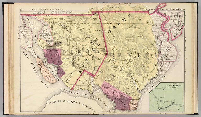
Thompson & West
Full Title
Map number seven (Solano County, Calif.) (with) Plat of Denverton, Solano Co. (Published by Thompson & West, San Francisco, Cala, 1878)
Publisher
Thompson & West
Author
Thompson & West
Full Title
Map of Vallejo, Solano Co., Cal. (with) Map number eight (Solano County, Calif.) (with) Bridgeport, Solano County, Cal. (Published by Thompson & West, San Francisco, Cala, 1878)
Publisher
Thompson & West
Author
Thompson & West
Full Title
Map of Benicia, Solano County, Cal. (Published by Thompson & West, San Francisco, Cala, 1878)
Publisher
Thompson & West
Author
Cram, George Franklin
Full Title
(Title Page to) Cram's Standard American Railway System Atlas Of The World. Accompanied with a Complete and Simple index of the United States ... Maps Of The United States Are The Largest Scale And Clearest Print Of Any Atlas Maps Published. Foreign Maps Are Compiled Largely From Charts Of The Royal Geographical Society, And Are Geographically Correct. Published by George F. Cram, 61-63 Plymouth Place, Chicago, Ill. 130 Fulton Street, New York. 1901. (on verso) Copyright Secured By George F. Cram, 1901.
Publisher
George F. Cram
Author
Cram, George Franklin
Full Title
Maine.
Publisher
George F. Cram
Author
Cram, George Franklin
Full Title
New Hampshire and Vermont.
Publisher
George F. Cram
Author
Johnston, Alexander Keith, 1804-1871
Full Title
European Russia by Keith Johnston, F.R.S.E. Engraved & printed by W. & A.K. Johnston, Edinburgh. William Blackwood & Sons, Edinburgh & London, (1861)
Publisher
William Blackwood & Sons
Author
Cram, George Franklin
Full Title
Commercial Railroad and County Map of Massachusetts and Rhode Island. (inset) (Boston and Vicinity).
Publisher
George F. Cram
Author
Cram, George Franklin
Full Title
Connecticut.
Publisher
George F. Cram
Author
Cram, George Franklin
Full Title
New York, Western Half. (inset) (Long Island).
Publisher
George F. Cram
Author
Cram, George Franklin
Full Title
New York, Eastern Half.
Publisher
George F. Cram
Author
Johnston, Alexander Keith, 1804-1871
Full Title
South-west Russia showing the extent of the Kingdom of Poland previous to its partition in 1772 by Keith Johnston, F.R.S.E. Engraved & printed by W. & A.K. Johnston, Edinburgh. William Blackwood & Sons, Edinburgh & London, (1861)
Publisher
William Blackwood & Sons
Author
Cram, George Franklin
Full Title
New York.
Publisher
George F. Cram
Author
Cram, George Franklin
Full Title
Western Half of Pennsylvania.
Publisher
George F. Cram
Author
Cram, George Franklin
Full Title
Eastern Half of Pennsylvania.
Publisher
George F. Cram
Author
Cram, George Franklin
Full Title
(Composite of) Pennsylvania.
Publisher
George F. Cram
Author
Cram, George Franklin
Full Title
Pennsylvania. Copyright 1899, by Geo. F. Cram.
Publisher
George F. Cram
Author
Cram, George Franklin
Full Title
New Jersey. Copyright, 1901, by Geo. F. Cram. (inset) Environs of Hudson County.
Publisher
George F. Cram
Author
Johnston, Alexander Keith, 1804-1871
Full Title
Asia by Keith Johnston, F.R.S.E. Engraved & printed by W. & A.K. Johnston, Edinburgh. William Blackwood & Sons, Edinburgh & London, (1861)
Publisher
William Blackwood & Sons
Author
Cram, George Franklin
Full Title
Maryland and Delaware. (inset) Baltimore County.
Publisher
George F. Cram
Author
Cram, George Franklin
Full Title
Western Half of Virginia and West Virginia.
Publisher
George F. Cram
|