Browse All

1844 Patagonia, Feuerland, Falklands, Antarct … World Atlas Sudlichster Theil von America enthaltend … |

1964 Roads, Radio, And Television State Atlas 33. Roads, Radio, And Television. Source … |

1964 Health, Sports, and Recreation State Atlas 40. Health, Sports, and Recreation. Sour … |

1964 Sickness State Atlas 41. Sickness. Sources: Florida Medical A … |

1823 Sweden and Norway. World Atlas Sweden and Norway. (with) inset map of I … |

1862 Uranogaphie moderne. World Atlas Tableau d'uranogaphie moderne ou systeme … |

1862 Principales projections. World Atlas Tableau des principales projections usit … |

1944 One World, One War World Atlas One World, One War. (inset) Complete Azi … |

1944 Outward From The U.S. World Atlas Outward From The U.S. (to accompany) Loo … |

1944 Northeast To Europe World Atlas Northeast To Europe. (drawn by) Richard … |

1862 Geographie de l'antiquite. World Atlas Tableau synoptique de la geographie de l … |

1944 Northwest To Asia World Atlas Northwest To Asia. (to accompany) Look A … |

1944 Southeast To Latin America World Atlas Southeast to Latin America. (drawn by) R … |
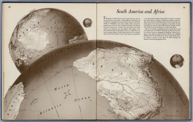
1944 South America To Africa World Atlas South America To Africa. (drawn by) Rich … |

1944 The U.S. From The Outside World Atlas The U.S. From The Outside. (to accompany … |

1944 Atlantic Arena World Atlas Atlantic Arena. Orthographic Projection. … |

1862 Connaissances geographiques. World Atlas Tableau comparatif de l'etat des connais … |

1944 Europe From The Northwest World Atlas Europe From the Northwest. (drawn by) Ri … |

1944 Europe From The Northwest World Atlas Europe From the Southwest. Drawn by Rich … |

1944 Europe From The East World Atlas Europe From the East. (drawn by) Richard … |

1944 World Island World Atlas World Island. Orthographic Projection. ( … |

1944 Southeast To Asia World Atlas Southeast To Asia. (drawn by) Richard Ed … |

1944 Russia From The South World Atlas Russia From The South. (drawn by) Richar … |

1862 Le Monde, principales decouvertes. World Atlas Tableau du Monde actuel du planisphere t … |

1944 China from the East World Atlas China From the East. (drawn by) Richard … |

1944 Pacific Arena World Atlas Pacific Arena. Orthographic Projection. … |

1944 Japan To Alaska World Atlas Japan To Alaska. (drawn by) Richard Edes … |

1944 Japan From The Solomons World Atlas Japan From The Solomons. (drawn by) Rich … |

1862 Courants atmospheriques, oceaniques. World Atlas Tableau general des courants atmospheriq … |

1944 Japan From China World Atlas Japan From China. (drawn by) Richard Ede … |

1944 Japan From Siberia World Atlas Japan From Siberia. (drawn by) Richard E … |

1944 Arctic Arena World Atlas Arctic Arena. Orthographic Projection. ( … |
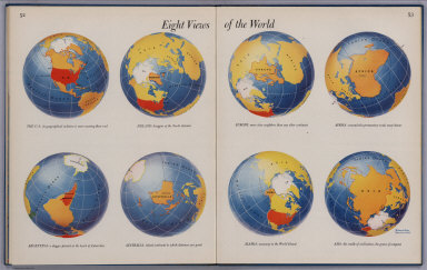
1944 Eight Views Of The World World Atlas Eight Views Of The World. (by) Richard E … |

1944 Great Circle Airways World Atlas Great Circle Airways. Natural scale at p … |

1862 Navigation, les oceans. World Atlas Tableau general de navigation ou des rou … |

1862 Thermometrie. World Atlas Tableau general de thermometrie dans les … |

1862 Systeme magnetique terrestre. World Atlas Tableau synoptique et abrege du systeme … |

1824 The World School Atlas The World. Engraved by A. Willard & J.W. … |

1824 Chart Of The Inhabited World School Atlas Chart Of The Inhabited World. Exhibiting … |

1824 Physical Chart Of The World School Atlas Physical Chart Of The World: Or View Of … |

1862 Diverses projections. World Atlas Tableau des diverses projections des car … |

1824 North America School Atlas North America. Engraved by A. Willard & … |

1824 United States School Atlas United States. Entered ... 1821, by Will … |

1824 South America School Atlas South America. Entered ... 1821, by Will … |

1862 Regions circumpolaires. World Atlas Tableau des regions circumpolaires ou ca … |

1824 Europe School Atlas Europe. Engraved by A. Willard & J.W. Ba … |

1824 Asia School Atlas Asia. Engraved by A. Willard & J.W. Barb … |

1824 Africa School Atlas Africa. Engraved by A. Willard & J.W. Ba … |

1862 Mappemonde. World Atlas Tableau spheroidal de la terre ou mappem … |

1862 La sphericite de la terre. World Atlas Tableau synoptique de la sphericite de l … |