Browse All

1875 St. John: Dukes & Sydney Wards. (New Bru … County Atlas Plan of St. John, Dukes & Sydney Wards. … |

1875 Plan of St. John, Queens Ward. (New Brun … County Atlas Plan of St. John, Queens Ward. (New Brun … |

1875 St. John: Kings Ward. (New Brunswick). County Atlas Plans of St. John, Kings Ward. (New Brun … |

1875 St. John: Wellington & Prince Wards. (Ne … County Atlas Plans of St. John, Wellington & Prince W … |

1875 St. John: Brooks Ward, Carleton. (New Br … County Atlas Plans of St. John, Brooks Ward, Carleton … |

1875 St. John: Guys & Albert Wards, Carleton. … County Atlas Plans of St. John, Guys & Albert Wards, … |

1875 Composite: St. John City. (New Brunswick … County Atlas (Composite of) St. John City. (New Bruns … |

1875 Portland (New Brunswick). County Atlas Town of Portland. (New Brunswick). |

1875 Portland, Village Plan No. 1. (New Bruns … County Atlas Portland, Village Plan No. 1. (New Bruns … |

1875 Portland, Village Plan No. 2. (New Bruns … County Atlas Portland, Village Plan No. 2. (New Bruns … |

1875 Portland, Village Plan No. 3. (New Bruns … County Atlas Portland, Village Plan No. 3. (New Bruns … |

1875 Portland, Village Plan No. 4. (New Bruns … County Atlas Portland, Village Plan No. 4. (New Bruns … |

1875 Parish of Lancaster. (New Brunswick). County Atlas Parish of Lancaster. (New Brunswick). |

1875 Part of the Parish of Lancaster No. 1. ( … County Atlas Part of the Parish of Lancaster No. 1. ( … |

1875 Part of the Parish of Lancaster No. 2. ( … County Atlas Part of the Parish of Lancaster No. 2. ( … |

1875 Fairville. (New Brunswick). County Atlas Fairville. (New Brunswick). |

1875 Musquash. (New Brunswick). County Atlas Musquash. (New Brunswick). |

1875 South Bay. (New Brunswick). County Atlas South Bay. (New Brunswick). |

1875 Parish of Simonds. (New Brunswick). County Atlas Parish of Simonds. (New Brunswick). |

1875 Part of Simonds including Crouchville, C … County Atlas Part of Simonds including Crouchville, C … |

1875 Parish of St. Martins. (New Brunswick). County Atlas Parish of St. Martins. (New Brunswick). |

1875 Quaco. (New Brunswick). County Atlas Quaco. (New Brunswick). |

1884 Position of the Forest, Prairie and Tree … Physical Atlas Map Showing the Position of the Forest, … |

1884 Natural Divisions of the North American … Physical Atlas Map Showing the Natural Divisions of the … |

1884 Distribution of Genus Fraxinus [The Ashe … Physical Atlas Map Showing the Distribution of Genus Fr … |

1884 Distribution of the Genera Carya & Umbel … Physical Atlas Map Showing the Distribution of the Gene … |

1884 Distribution of the Genus Juglans [The W … Physical Atlas Map Showing the Distribution of the Genu … |

1884 Distribution of the Genus Quercus [The O … Physical Atlas Map Showing the Distribution of the Genu … |

1874 Map of Rochester, Minn. State Atlas Map of Rochester ... in Cascade & Roches … |

1884 Distribution of the Genera Castanea & Ca … Physical Atlas Map Showing the Distribution of the Gene … |

1884 Distribution of the Genus Pinus [The Pin … Physical Atlas Map Showing the Distribution of the Genu … |

1884 Distribution of the Genus Abies & Picea … Physical Atlas Map Showing the Distribution of the Genu … |

1884 Distribution of Liriodendron Tulipifera … Physical Atlas Map Showing the Distribution of Lirioden … |

1884 Distribution of Prosopsis Juliflora, Que … Physical Atlas Map Showing the Distribution of Prosopsi … |

1884 Distribution of Fraxinus Americana & Pin … Physical Atlas Map Showing the Distribution of Fraxinus … |

1884 Distribution of the Genera Chamaecyparis … Physical Atlas Map Showing the Distribution of the Gene … |

1884 Distribution of the Genera Thuya, Taxodi … Physical Atlas Map Showing the Distribution of the Gene … |

1884 Distribution of Pinus Strobus, P. (Pinus … Physical Atlas Map Showing the Distribution of Pinus St … |
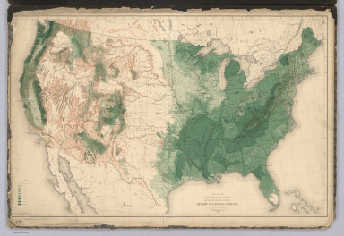
1884 United States showing the Relative Avera … Physical Atlas Map of the United States showing the Rel … |

1874 Map of Olmsted County, Minn. State Atlas Map of Olmsted County, Minn. (Published … |

1872 Hume. Como. Whiteside County, Illinois. [National Atlas, State Atlas] Hume. (inset) Como. |

1872 Tampico, Whiteside County, Illinois. [National Atlas, State Atlas] Tampico. (inset) Tampico. |

1875 Counties of Emmet, Palo Alto, Kossuth, W … State Atlas Counties of Emmet, Palo Alto, Kossuth, W … |

1872 Erie. Springhill. Portland. Whiteside Co … [National Atlas, State Atlas] Erie & Portland. (insets) Erie. Springhi … |

1872 Fenton. Pratt. Whiteside County, Illinoi … [National Atlas, State Atlas] Fenton. (inset) Pratt. |

1875 Plans of Osage, West Union, Webster City … State Atlas Plan of Osage, Mitchell Co. (with) Plan … |

1872 Albany, Whiteside County, Illinois. [National Atlas, State Atlas] Albany. Town of Albany. |

1872 Union Grove, Whiteside County, Illinois. [National Atlas, State Atlas] Union Grove. |

1872 City of Fulton, Whiteside County, Illino … [National Atlas, State Atlas] City of Fulton. |

1872 Ustick, Whiteside County, Illinois. [National Atlas, State Atlas] Ustick. |