Browse All

1869 Yosemite Valley. Guide Book Map of the Yosemite Valley from Surveys … |

1868 A Portion of the Sierra Nevada adjacent … Guide Book Map of a Portion of the Sierra Nevada ad … |

1870 Yosemite Valley. Guide Book Map of the Yosemite Valley from Surveys … |

1870 A Portion of the Sierra Nevada adjacent … Guide Book Map of a Portion of the Sierra Nevada ad … |

1876 Addison County, Vermont. State Atlas Plan of Addison County, Vermont. (Publis … |

1872 Routes from San Francisco to the Yosemit … Guide Book Map of the Routes from San Francisco to … |

1874 Yosemite Valley. Guide Book Map of the Yosemite Valley, prepared to … |

1874 Sketch of the Hetch Hetchy Valley. Guide Book Sketch of the Hetch Hetchy Valley. (Stat … |

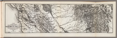
1874 Portion of the Sierra Nevada adjacent to … Guide Book Map of a Portion of the Sierra Nevada ad … |
1871 Routes from San Francisco to the Yosemit … Guide Book Map of the Routes from San Francisco to … |

1871 Yosemite Valley. Guide Book Map of the Yosemite Valley, prepared to … |

1872 Map of the Yosemite Valley. Guide Book Map of the Yosemite Valley, prepared to … |
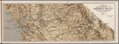
1872 Routes from San Francisco to the Yosemit … Guide Book Map of the Routes from San Francisco to … |

1876 City of Vergennes, Town of Middlebury. State Atlas City of Vergennes, Addison County, Vermo … |

1869 Antietam. Military Atlas Antietam. Prepared by Bvt. Brig. Gen N. … |

1868 New York. County Atlas New York. (insets) Oswego, Buffalo, Roch … |

1868 Montgomery Co. New York County Atlas Outline Map of Montgomery Co. New York. |

1868 Village of Amsterdam, New York. County Atlas The Village of Amsterdam. |

1868 Amsterdam, Montgomery County, New York. … County Atlas Amsterdam, Montgomery Co. (inset) Rock C … |

1868 Florida, Montgomery County, New York. Fo … County Atlas Florida, Montgomery Co. (inset) Fort Hun … |

1868 Tribes Hill. Port Jackson. Minaville, Ne … County Atlas Tribes Hill. Port Jackson. Minaville. |

1876 Plan of Orange County, Vermont. State Atlas Plan of Orange County, Vermont. (Publish … |

1868 Glen, Montgomery County, New York. Aurie … County Atlas Glen, Montgomery Co. (inset) Auriesville … |

1868 Fonda. Fultonville, New York. County Atlas Fonda. Fultonville |

1868 Charleston, Montgomery County, New York. … County Atlas Charleston, Montgomery Co. (insets) Burt … |

1868 St. Johnsville and Mohawk, Montgomery Co … County Atlas St. Johnsville, Montgomery Co. N.Y. Moha … |

1868 Root, Montgomery County, New York. Spake … County Atlas Root, Montgomery Co. (insets) Spakers Ba … |

1868 Palatine, Montgomery County, New York. P … County Atlas Palatine, Montgomery County, New York. ( … |

1868 Canajoharie. Nelliston. County Atlas Canajoharie. Nelliston. |

1868 Canajoharie, Montgomery County, New York … County Atlas Canajoharie, Montgomery Co., N.Y. (inset … |

1868 Fort Plain, New York. County Atlas Fort Plain. |

1868 Minden, Montgomery County, New.York. Min … County Atlas Minden, Montgomery Co. (insets) Minden o … |

1868 Saint Johnsville, New York. County Atlas Plan of Saint Johnsville. |

1868 Outline Map of Fulton County, New York. County Atlas Outline Map of Fulton Co. New York. |

1876 St. Johnsbury. Town of St. Johnsbury. State Atlas St. Johnsbury: Town of St. Johnsbury. (P … |

1868 Johnstown, Fulton County, New York. County Atlas City of Johnstown. |

1868 Gloversville, Fulton County, New York. County Atlas Gloversville, Fulton Co. N.Y. |

1868 Johnstown, Fulton County, New York. County Atlas Johnstown, Fulton Co. |

1868 Mayfield and Perth, Fulton County, New Y … County Atlas Mayfield, Fulton Co. Perth, Fulton Co. ( … |

1868 Northampton, Fulton County, New York. No … County Atlas Northampton, Fulton Co. N.Y. (insets) No … |

1868 Broad Albin, Fulton County, New York. Br … County Atlas Broad Albin, Fulton County, N.Y. (inset) … |

1868 Bleecker, Fulton County, New York. County Atlas Bleecker, Fulton Co. |

1868 Caroga, Fulton County, New York. Newkirk … County Atlas Caroga, Fulton Co. (insets) Newkirks Mil … |

1868 Stratford, Fulton County, New York. Stra … County Atlas Stratford, Fulton Co. (inset) Stratford … |

1868 Ephratah, Fulton County, New York. Lasse … County Atlas Ephratah, Fulton Co. (insets) Lassellvil … |

1868 Oppenheim, Fulton County, New York. Oppe … County Atlas Oppenheim, Fulton Co. (inset) Oppenheim. |

1869 Harper's Ferry. Military Atlas Harper's Ferry. Prepared by Bvt. Brig. G … |

1874 United States and Territories together w … County Atlas Map of the United States and Territories … |

1874 New York. County Atlas Plan of the State of New York, Drawn and … |

1874 Schuyler County, New York. County Atlas Outline Plan of Schuyler Co., New York. |