Browse All

1956 Shell Highway Map of United States. National Atlas Shell Map of the United States (cover ti … |

1951 Shell Highway Map of Western United Stat … National Atlas Shell Map of Western and Central United … |

1951 Shell Highway Map of Central United Stat … National Atlas Shell Highway Map of Central United Stat … |

1951 Shell Highway Map Northeastern Section o … National Atlas Shell Map of Eastern United States (cove … |

1951 Shell Highway Map Southeastern Section o … National Atlas Shell Highway Map Southeastern Section o … |

1956 Shell Sectional Map No. 1 - New England … National Atlas Shell Sectional Map of New England State … |

1956 Various Regions and Cities in New Englan … National Atlas Hartford. New Haven. New York (City) and … |

1956 Shell Sectional Map No. 2 - North Atlant … National Atlas Shell Sectional Map of North Atlantic St … |

1956 Various Regions and Cities in the North … National Atlas New York (city) and Vicinity. Detroit. C … |

1956 Shell Sectional Map No. 3 - Middle Atlan … National Atlas Shell Sectional Map of Middle Atlantic S … |

1956 Various Regions and Cities in the Middle … National Atlas New York and Vicinity. Philadelphia and … |

1956 Shell Sectional Map No. 4 - East Central … National Atlas Shell Sectional Map of East Central Stat … |

1956 Various Regions and Cities in the East C … National Atlas Pittsburgh. Cincinnati. Indianapolis. Co … |

1956 Shell Sectional Map No. 5 - Southeastern … National Atlas Shell Sectional Map of Southeastern Stat … |

1956 Various Regions and Cities in the Southe … National Atlas Atlanta. Birmingham. Savannah. Montgomer … |

1956 Shell Sectional Map No. 6 - North Centra … National Atlas Shell Map of North Central States (cover … |

1956 Various Regions and Cities in the North … National Atlas Chicago and Vicinity. Milwaukee. Toledo. … |

1956 Shell Sectional Map No. 7 - South Centra … National Atlas Shell Sectional Map of South Central Sta … |

1956 Various Regions and Cities in the South … National Atlas St. Louis and Vicinity. (Verso to) Shell … |

1956 Shell Sectional Map No. 8 - Gulf States. National Atlas Shell Sectional Map of Gulf States (cove … |

1956 Various Regions and Cities in the Shell … National Atlas Birmingham. Chattanooga. Dallas. Fort Wo … |

1956 Shell Sectional Map No. 9 - Northwestern … National Atlas Shell Sectional Map of Northwestern Stat … |

1956 Various Regions and Cities in the Northw … National Atlas Denver. Des Moines. Minneapolis - St. Pa … |

1956 Shell Sectional Map No. 10 - Southwester … National Atlas Shell Sectional Map of Southwestern Stat … |

1956 Various Regions and Cities in the Southw … National Atlas Dallas. Denver. Fort Worth. Oklahoma Cit … |

1956 Shell Sectional Map No. 11- Pacific Nort … National Atlas Shell Sectional Map of Pacific Northwest … |

1956 Various Regions and Cities in the National Atlas Boise. Eugene. Klamath Falls. Lewiston. … |

1956 Shell Sectional Map No. 12- Pacific Sout … National Atlas Shell Sectional Map of Pacific Southwest … |

1927 Mileage chart U.S. National Atlas Mileage chart of the United States. Copy … |

1927 United States. National Atlas Rand McNally junior auto road map United … |

1927 Principal map of cities National Atlas (Cities, Principal maps). Edition 1262. … |

1927 Transcontinental Highway map National Atlas Transcontinental Highway map. (Copyrigth … |

1927 Sectional paved road map National Atlas Sectional paved road map. Copyrighted by … |

1927 Sectional paved road map (Continues) National Atlas Sectional paved road map. Copyrighted by … |

1927 Sectional paved road map (Continues) National Atlas Sectional paved road map. Copyrighted by … |

1927 Sectional paved road map (Continues) National Atlas Sectional paved road map. Copyrighted by … |

1927 Sectional paved road map (Continues) National Atlas Sectional paved road map. Copyrighted by … |

1927 Sectional paved road map (Continues) National Atlas Sectional paved road map. Copyrighted by … |

1927 Sectional paved road map (Continues) National Atlas Sectional paved road map. Copyrighted by … |

1927 Sectional paved road map (Continues) National Atlas Sectional paved road map. Copyrighted by … |

1927 Sectional paved road map (Continues) National Atlas Sectional paved road map. Copyrighted by … |

1927 Sectional paved road map (Continues) National Atlas Sectional paved road map. Copyrighted by … |
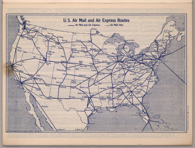
1940 U.S. Air Mail and Air Express Routes National Atlas U.S. Air Mail and Air Express Routes. Co … |

1940 United States Road Map National Atlas Rand McNally Road map, United States. Co … |

1940 Transcontinental Mileage Chart of the Un … National Atlas Rand McNally Transcontinental Mileage Ch … |

1939 Rand McNally Road map: United States National Atlas Rand McNally Road map: United States. Co … |

1939 Rand McNally Road map: Alabama National Atlas Rand McNally Road map: Alabama. Copyrigh … |

1939 Rand McNally Road map: Arizona, New Mexi … National Atlas Rand McNally Road map: Arizona, New Mexi … |

1939 Rand McNally Road map: Arkansas, Louisia … National Atlas Rand McNally Road map: Arkansas, Louisia … |

1939 Rand McNally Road map: California National Atlas Rand McNally Road map: California. Copyr … |