Who What Where WhenREMOVEWHAT |
REFINE
Browse All : Book Map and Exploration Book of California
1-21 of 21
Author
Emory, William H.
Full Title
Military Reconnaissance Of The Arkansas Rio Del Norte And Rio Gila By W.H. Emory, Lieut. Top. Engrs. Assisted ... by J.W. Abert and W.G. Peck, and ... by W.H. Warner and Mr. Norman Bestor, Made in 1846-7, with the advance guard of the "Army of the West". Under Command Of Brig. Gen. Stephn. W. Kearny. Constructed under the orders of Col. J.J. Abert ... 1847. Drawn by Joseph Welch. Engraved on stone by E. Weber & Co. Baltimore.
Publisher
Wendell and Van Benthuysen
Author
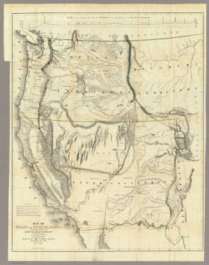
Fremont, J.C.
Full Title
Map Of An Exploring Expedition To The Rocky Mountains in the Year 1842, Oregon & North California In The Years 1843-44. By Brevet Capt. J. C. Fremont Of The Corps Of Topographical Engineers Under the orders of Col. J.J. Abert, Chief Of The Topographical Bureau. Lith. by E. Weber & Co. Baltimore, Md.
Publisher
Blair and Rives
Author
Fremont, J.C.
Full Title
Map Of Oregon And Upper California From the Surveys of John Charles Fremont And other Authorities. Drawn By Charles Preuss Under the Order of the Senate Of The United States, Washington City 1848. Lithy. by E. Weber & Co. Balto. (inset) Profile of the travelling route from the South Pass of the Rocky Mountains to the Bay of San Francisco.
Publisher
Wendell and Van Benthuysen
Author
Williamson, R.S.
Full Title
From San Francisco Bay to the Northern Boundary of California from Explorations and Surveys made under the direction of the Hon. Jefferson Davis Secretary of War by Lieut. R.S. Williamson, U.S. Topl. Engrs. and Lieut. H.L. Abbot, U.S. Topl. Engrs., H.C. Fillebrown, J. Young and C.D. Anderson, Assts. 1855. Explorations and surveys for a railroad route from the Mississippi River to the Pacific Ocean. War Department. Routes in Oregon and California. Map No. 1. Drawn by John Young.
Publisher
[A.O.P. Nicholson I-XI, T. Ford XII.]
Author
[Abbot, Henry L., Williamson, R.S.]
Full Title
Routes in Oregon and California. Profiles sheet no. 1 from Benicia to Fort Reading and from Fort Reading to Vancouver; from explorations and surveys made under the direction of Hon. Jefferson Davis, Sec. of War by Lieut. R.S. Williamson, U.S. Topl. Engrs. and Lieut. H.L. Abbot, U.S. Topl. Engrs, H.C. Fillerbrown, C.D. Anderson and J. Young assts. 1855. (1861)
Publisher
[A.O.P. Nicholson I-XI, T. Ford XII.]
Author
[Abbot, Henry L., Williamson, R.S.]
Full Title
Routes in Oregon and California. Profiles sheet no. 2 from the head of Des Chutes Valley to Vancouver and from Vancouver to Fort Reading; from explorations and surveys made under the direction of Hon. Jefferson Davis, Sec. of War by Lieut. R.S. Williamson, U.S. Topl. Engrs. and Lieut. H.L. Abbot, U.S. Topl. Engrs, H.C. Fillerbrown, C.D. Anderson and J. Young assts. 1855. (1861)
Publisher
[A.O.P. Nicholson I-XI, T. Ford XII.]
Author
Beckwith, E.G.
Full Title
From the Mud Lakes to the Pacific Ocean; from Explorations and Surveys made under the direction of the Hon. Jefferson Davis Secretary of War by Capt. E.G. Beckwith, 3d. Artillery. F.W. Egloffstein, Topographer for the Route. 1855. Explorations and surveys for a railroad route from the Mississippi River to the Pacific Ocean. War Department. Route near the 41st Parallel. Map No. 4. Selmar Siebert's Engraving & Printing Establishment. Washington, D.C.
Publisher
[A.O.P. Nicholson I-XI, T. Ford XII.]
Author
[Ives, J.C., Whipple, A.W.]
Full Title
From the Rio Grande to the Pacific Ocean from explorations and surveys made under the direction of the Hon. Jefferson Davis, Secretary of War by Lieut. A.W. Whipple, Topogl. Engrs. and Lieut. J.C. Ives, Topogl. Engrs. A.H. Campbell, Civil Eng. and Surveyor, Asst. Surveyors: Wm. White Jr., N.H. Hutton, and J.P. Sherburne. 1853-4. Explorations and Surveys for a Rail Road Route from the Mississippi River to the Pacific Ocean, War Department, Route Near the 35th Parallel, Map No. 2. Engr. by Selmar Siebert. Drawn by John D. Hoffmann.
Publisher
[A.O.P. Nicholson I-XI, T. Ford XII.]
Author
Williamson, R.S.
Full Title
General Map of Explorations and Surveys in California made under the direction of the Hon. Jefferson Davis, Secretary of War by Lieut. R.S. Williamson, Topogl. Engr. assisted by Lieut. J.G. Parke, Topl. Engr. and Mr. Isaac Williams Smith, Civ. Engr. 1853. Explorations and Surveys for a Rail Road Route from the Mississippi River to the Pacific Ocean. War Department. Routes in California to connect with the routes near the 32nd and 35th parallels. Engr. by Selmar Siebert.
Publisher
[A.O.P. Nicholson I-XI, T. Ford XII.]
Author
Williamson, R.S.
Full Title
Map of Passes in the Sierra Nevada from Walker's Pass to the Coast Range: from Explorations and Surveys made under the direction of the Hon. Jefferson Davis, Secretary of War by Lieut. R.S. Williamson Topl. Engr. assisted by Lieut. J.G. Parke Topl. Engr. and Mr. Isaac Williams Smith, Civ. Engr. 1853. Explorations and Surveys for a Rail Road Route from the Mississippi River to the Pacific Ocean. War Department. Routes in California to connect with the routes near the 32nd and 35th parallels. Engraved by Selmar Siebert.
Publisher
[A.O.P. Nicholson I-XI, T. Ford XII.]
Author
Williamson, R.S.
Full Title
Map and Profile of the Canada de las Uvas; from Explorations and Surveys made under the direction of the Hon. Jefferson Davis, Secretary of War by Lieut. R.S. Williamson Topl. Engr. assisted by Lieut. J.G. Parke Topl. Engr. and Mr. Isaac Williams Smith, Civ. Engr. 1853. Explorations and Surveys for a Rail Road Route from the Mississippi River to the Pacific Ocean. War Department. Routes in California to connect with the routes near the 32nd and 35th parallels. Engr. by Selmar Siebert.
Publisher
[A.O.P. Nicholson I-XI, T. Ford XII.]
Author
Williamson, R.S.
Full Title
Map and Profile of the Tejon Pass; from Explorations and Surveys made under the direction of the Hon. Jefferson Davis, Secretary of War by Lieut. R.S. Williamson Topl. Engr. assisted by Lieut. J.G. Parke Topl. Engr. and Mr. Isaac Williams Smith, Civ. Engr. 1853. Explorations and Surveys for a Rail Road Route from the Mississippi River to the Pacific Ocean. War Department. Routes in California to connect with the routes near the 32nd and 35th parallels. Engr. by Selmar Siebert.
Publisher
[A.O.P. Nicholson I-XI, T. Ford XII.]
Author
Williamson, R.S.
Full Title
Sheet no. 1. Profiles of passes in the Sierra Nevada; from Explorations and Surveys made under the direction of the Hon. Jefferson Davis, Secretary of War by Lieut. R.S. Williamson, Topl. Engr. assisted by Lieut. J.G. Parke, Topl. Engr. and Mr. Isaac Williams Smith, Civ. Engr. 1853. Explorations and Surveys for a Rail Road Route from the Mississippi River to the Pacific Ocean. War Department. Routes in California to connect with the routes near the 32nd and 35th parallels. (1861)
Publisher
[A.O.P. Nicholson I-XI, T. Ford XII.]
Author
Williamson, R.S.
Full Title
Sheet no. 2. Profiles of passes in the Sierra Nevada; from Explorations and Surveys made under the direction of the Hon. Jefferson Davis, Secretary of War by Lieut. R.S. Williamson, Topl. Engr. assisted by Lieut. J.G. Parke, Topl. Engr. and Mr. Isaac Williams Smith, Civ. Engr. 1853. Explorations and Surveys for a Rail Road Route from the Mississippi River to the Pacific Ocean. War Department. Routes in California to connect with the routes near the 32nd and 35th parallels. (1861)
Publisher
[A.O.P. Nicholson I-XI, T. Ford XII.]
Author
Parke, John G.
Full Title
From San Francisco Bay to the Plains of Los Angeles from Explorations and Surveys made under the direction of The Hon. Jefferson Davis, Secretary of War by Lieut. John G. Parke, Topl. Engrs. assisted by Albert H. Campbell, Civil Engineer and N.H. Hutton, H. Custer and G.G. Garner. 1854 & 55. Map No. 1. Constructed and drawn by H. Custer. Explorations and Surveys for a Rail Road Route from the Mississippi River to the Pacific Ocean. War Department. Coast Route, California.
Publisher
[A.O.P. Nicholson I-XI, T. Ford XII.]
Author
Parke, John G.
Full Title
From the Pimas Villages to Fort Fillmore from Explorations and Surveys made under the direction of The Hon. Jefferson Davis, Secretary of War by Lieut. John G. Parke, Topl. Engrs. assisted by Albert H. Campbell, Civil Engineer and N.H. Hutton, H. Custer and G.G. Garner. 1854 & 55. Map No. 2. Engr. by Selmar Siebert. Explorations and Surveys for a Rail Road Route from the Mississippi River to the Pacific Ocean. War Department. Route near the 32nd parallel of North Latitude.
Publisher
[A.O.P. Nicholson I-XI, T. Ford XII.]
Author
Parke, John G.
Full Title
Profiles from San Francisco Bay to Los Angeles, Cala. and from the Pimas Villages to Fort Fillmore from Explorations and Surveys made under the direction of The Hon. Jefferson Davis, Secretary of War by Lieut. John G. Parke, Topl. Engrs., assisted by Albert H. Campbell, Civil Engineer and N.H. Hutton, H. Custer and G.G. Garner, assts. 1854 & 55. Explorations and Surveys for a Rail Road Route from the Mississippi River to the Pacific Ocean. War Department. Route near the 32d parallel & coast route, Cala.
Publisher
[A.O.P. Nicholson I-XI, T. Ford XII.]
Author
Espinosa y Tello, J.
Full Title
Carta Esferica de los Reconocimientos Hechos en la Costa N.O. De America en 1791 y 92 por las Goletas Sutil y Mexicana, y otros Buques de S.M. Cardano lo grabo. Morata lo escribio. Numero 1.
Publisher
Imprenta Real
Author
[Espinosa y Tello, J., Martinez de Palacios, Geronimo]
Full Title
Carta de los reconocimientos hechos en 1602. Por el Capitan Sebastian Vizcayno Formada por los Planos que hizo el mismo durante su comision. Numo. 4. Cardano lo grabo.
Publisher
Imprenta Real
Author
Espinosa y Tello, J.
Full Title
Plano del Puerto de S. Diego en la Costa Setentl. de Californs. Levantado por el 2o. Piloto de la Armada D. Juan Pantoja. Ano 1782. Numo. 5. Cardano lo grabo. Morata lo escr.
Publisher
Imprenta Real
Author
Espinosa y Tello, J.
Full Title
Plano del Puerto y Bahia De Monte Rey situado en la Costa de Californs. Tabajado a bordo de las Corvetas Descubierta y Atrevida. Ano 1791. Cardano lo grabo. Morata lo escribio. Numo. 6.
Publisher
Imprenta Real
1-21 of 21
|