Who What Where WhenREMOVEWHAT |
REFINE
Browse All : Book Map and Exploration Book of Oregon
1-8 of 8
Author
Fremont, J.C.
Full Title
Map Of An Exploring Expedition To The Rocky Mountains in the Year 1842, Oregon & North California In The Years 1843-44. By Brevet Capt. J. C. Fremont Of The Corps Of Topographical Engineers Under the orders of Col. J.J. Abert, Chief Of The Topographical Bureau. Lith. by E. Weber & Co. Baltimore, Md.
Publisher
Blair and Rives
Author
Fremont, J.C.
Full Title
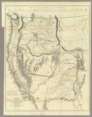
Map Of Oregon And Upper California From the Surveys of John Charles Fremont And other Authorities. Drawn By Charles Preuss Under the Order of the Senate Of The United States, Washington City 1848. Lithy. by E. Weber & Co. Balto. (inset) Profile of the travelling route from the South Pass of the Rocky Mountains to the Bay of San Francisco.
Publisher
Wendell and Van Benthuysen
Author
Williamson, R.S.
Full Title
From the Northern Boundary of California to the Columbia River from Explorations and Surveys made under the direction of the Hon. Jefferson Davis Secretary of War by Lieut. R.S. Williamson, U.S. Topl. Engrs. and Lieut. H.L. Abbot, U.S. Topl. Engrs., H.C. Fillebrown, J. Young and C.D. Anderson, Assts. 1855. Explorations and surveys for a railroad route from the Mississippi River to the Pacific Ocean. War Department. Routes in Oregon and California. Map No. 2. Drawn by John Young. Engd. by Selmar Siebert.
Publisher
[A.O.P. Nicholson I-XI, T. Ford XII.]
Author
[Abbot, Henry L., Williamson, R.S.]
Full Title
Routes in Oregon and California. Profiles sheet no. 1 from Benicia to Fort Reading and from Fort Reading to Vancouver; from explorations and surveys made under the direction of Hon. Jefferson Davis, Sec. of War by Lieut. R.S. Williamson, U.S. Topl. Engrs. and Lieut. H.L. Abbot, U.S. Topl. Engrs, H.C. Fillerbrown, C.D. Anderson and J. Young assts. 1855. (1861)
Publisher
[A.O.P. Nicholson I-XI, T. Ford XII.]
Author
[Abbot, Henry L., Williamson, R.S.]
Full Title
Routes in Oregon and California. Profiles sheet no. 2 from the head of Des Chutes Valley to Vancouver and from Vancouver to Fort Reading; from explorations and surveys made under the direction of Hon. Jefferson Davis, Sec. of War by Lieut. R.S. Williamson, U.S. Topl. Engrs. and Lieut. H.L. Abbot, U.S. Topl. Engrs, H.C. Fillerbrown, C.D. Anderson and J. Young assts. 1855. (1861)
Publisher
[A.O.P. Nicholson I-XI, T. Ford XII.]
Author
[Gunnison, J.W., Preuss, C., Stansbury, Howard]
Full Title
Map of a Reconnoissance between Fort Leavenworth on the Missouri River, and the Great Salt Lake in the Territory Of Utah, made in 1849 and 1850 under the orders of Col. J.J. Abert ... By Capt. Howard Stansbury ... aided by Lieut. J.W. Gunnison ... and Albert Carrington. The adjacent country laid down from the latest and most authentic data. Drawn by Lieut. Gunnison and Charles Preuss. Ackerman Lith. 379 Broadway N.Y.
Publisher
Ackerman Lith.
Author
[United States Exploring Expedition (1838-1842), Wilkes, Charles, 1798-1877]
Full Title
Map of the Oregon Territory by the U.S. Ex. Ex. Charles Wilkes Esqr. Commander. 1841. J.H. Young & Sherman & Smith, N.Y. (with) Columbia River reduced from a survey made by the U.S. Ex. Ex. 1841.
Publisher
Lea & Blanchard
1-8 of 8
|