Browse All

1861 General Map of Explorations and Surveys … Exploration Book General Map of Explorations and Surveys … |

1861 Passes, Sierra Nevada, Walker's Pass-Coa … Exploration Book Map of Passes in the Sierra Nevada from … |

1861 Map and Profile of Canada de las Uvas. Exploration Book Map and Profile of the Canada de las Uva … |

1861 Map and Profile of Tejon Pass. Exploration Book Map and Profile of the Tejon Pass; from … |

1861 1. Profiles, passes in the Sierra Nevada … Exploration Book Sheet no. 1. Profiles of passes in the S … |

1861 2. Profiles, passes in the Sierra Nevada … Exploration Book Sheet no. 2. Profiles of passes in the S … |

1861 From San Francisco Bay to Plains of Los … Exploration Book From San Francisco Bay to the Plains of … |

1861 From the Pimas Villages to Fort Fillmore … Exploration Book From the Pimas Villages to Fort Fillmore … |

1861 Profiles San Francisco Bay-Los Angeles & … Exploration Book Profiles from San Francisco Bay to Los A … |

1861 From the Red River to the Rio Grande. Exploration Book From the Red River to the Rio Grande; fr … |

1895 Land of the Standing Rocks. Exploration Book Bird's-eye view of the Land of the Stand … |

1776 Map of the Middle British Colonies in No … [Exploration Book, Geography Book] A Map of the Middle British Colonies in … |

1856 A New Map of the Great West Exploration Book The States and Territories of The Great … |

1856 Reconnoissances in the Dacota Country. Exploration Book Reconnoissances in the Dacota Country By … |

1861 Map Of The Territory Of The United State … Exploration Book Map Of The Territory Of The United State … |

1874 A geological map of the Black Hills: by … Exploration Book A geological map of the Black Hills: by … |

1874 Map of a reconnaissance of the Black Hil … Exploration Book Map of a reconnaissance of the Black Hil … |

1874 Map of the Black Hills from a reconnaiss … Exploration Book Map of the Black Hills from a reconnaiss … |

1876 Judith Basin : drawn under the direction … Exploration Book Judith Basin : drawn under the direction … |

1876 Upper Geyser Basin : drawn under the dir … Exploration Book Upper Geyser Basin : drawn under the dir … |

1875 Map of a Reconnaissance From Carroll, Mo … Exploration Book Map of a Reconnaissance From Carroll, Mo … |

1879 Sketch of Black Rock and vicinity, Utah … Exploration Book Sketch of Black Rock and vicinity, Utah … |

1879 Comparative map of Great Salt Lake, Utah … Exploration Book Comparative map of Great Salt Lake, Utah … |

1878 Map of Utah territory : representing the … Exploration Book Map of Utah territory : representing the … |

1878 Map of the United States exhibiting the … Exploration Book Map of the United States exhibiting the … |

1879 Rain chart of the United States Exploration Book Rain chart of the United States : showin … |
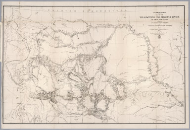
1868 Map of the Yellowstone and Missouri Rive … Exploration Book U.S. War Department : Map of the Yellows … |

1858 Map illustrating Baldwin Mollhausen's tr … Exploration Book Map illustrating Baldwin Mollhausen's tr … |

1880 Map Showing Geographical Divisions of th … Exploration Book Map Showing Geographical Divisions of th … |

1819 Vincennes district. Exploration Book Vincennes district. Drawn by David Thoma … |

1864 Geological map and profiles of some of t … Exploration Book Geological map and profiles of some of t … |
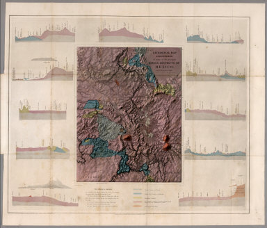
1864 Geological map and profiles of some of t … Exploration Book Geological map and profiles of some of t … |

1852 Map of the Great Salt Lake. Exploration Book Map of the Great Salt Lake And Adjacent … |

1852 Map of a Reconnoissance between Fort Lea … Exploration Book Map of a Reconnoissance between Fort Lea … |

1842 Chart Of The World Shewing The Tracks of … Exploration Book Chart Of The World Shewing The Tracks of … |

1840 Chart of the Antarctic Continent. Exploration Book Chart of the Antarctic Continent Shewing … |

1840 Chart of the Viti Group or Feejee Island … Exploration Book Chart of the Viti Group or Feejee Island … |

1841 Map of the Oregon Territory. Exploration Book Map of the Oregon Territory by the U.S. … |

1841 Map of Part of the Island of Hawaii, San … Exploration Book Map of Part of the Island of Hawaii, San … |

1777 S. extremity of America. Exploration Book A chart of the southern extremity of Ame … |

1777 S. Atlantic discoveries. Exploration Book Chart of the discoveries made in the Sou … |

1785 Kerguelen's Land. Exploration Book Kerguelen's Land called by C. Cook Islan … |

1785 Port Palliser, Christmas Harbour. Exploration Book Sketch of Port Palliser on Kerguelen's-L … |

1785 Van Diemen's Land. Exploration Book Chart of Van Diemen's Land. Harmar scrip … |

1785 Adventure Bay, Van Diemens Land. Exploration Book Plan of Adventure Bay in Van Diemens Lan … |

1785 Friendly Islands chart. Exploration Book Chart of the Friendly Islands. Writing b … |

1785 Tongataboo Harbour. Exploration Book Sketch of Tongataboo Harbour, 1777. The … |

1785 (Wanooaette, Wateeoo, Mangeea, Toobouai … Exploration Book (Plans of islands in the South Pacific. … |

1785 Eimeo harbours. Exploration Book Sketch of the harbours on the north side … |

1785 Christmas Island. Exploration Book Christmas Island. Latitude 1058' N. Long … |