Browse All

1896 Map of the Golden Gate Park. Guide Book Map of the Golden Gate Park, the Avenue … |

1896 Sonoma, Marin, Lake, and Napa Counties. Guide Book Untitled map of Sonoma, Marin, Lake, and … |

1896 San Mateo, Santa Cruz, Santa Clara, Alam … Guide Book (Untitled map of the South Bay including … |

1896 Colusa, Yolo, Napa, Butte, Yuba, Sutter, … Guide Book (Untitled map of the area around Sacrame … |

1896 San Benito, Fresno, Monterey, San Luis O … Guide Book (Untitled map of the Central Coast area … |

1896 Sacramento, Amador, Calaveras, San Joaqu … Guide Book (Untitled map of the Central Valley area … |

1896 Ventura, Los Angeles, San Bernardino, Or … Guide Book (Untitled map of Southern California inc … |

1896 Map of California Roads for Cyclers. Guide Book Map of California Roads for Cyclers. Thi … |

1848 Military Reconnaissance Of The Arkansas … Exploration Book Military Reconnaissance Of The Arkansas … |

1845 Map Of An Exploring Expedition To The Ro … Exploration Book Map Of An Exploring Expedition To The Ro … |
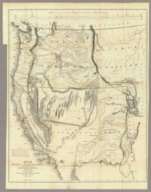
1848 Map Of Oregon And Upper California. Exploration Book Map Of Oregon And Upper California From … |

1851 Official Map of San Francisco. City Atlas Official Map of San Francisco, Compiled … |

1892 Map of California. Guide Book Map of California, prepared for the Stat … |

1908 Map of California. Pamphlet Geographical, topographical and railroad … |

1861 San Francisco Bay to N. boundary of Cali … Exploration Book From San Francisco Bay to the Northern B … |

1861 Profiles 1 Benicia-Ft. Reading & Ft. For … Exploration Book Routes in Oregon and California. Profile … |

1861 Profiles 2 Des Chutes Valley-Vancouver & … Exploration Book Routes in Oregon and California. Profile … |

1861 From the Mud Lakes to Pacific Ocean. Exploration Book From the Mud Lakes to the Pacific Ocean; … |

1861 From the Rio Grande to the Pacific Ocean … Exploration Book From the Rio Grande to the Pacific Ocean … |

1861 General Map of Explorations and Surveys … Exploration Book General Map of Explorations and Surveys … |

1861 Passes, Sierra Nevada, Walker's Pass-Coa … Exploration Book Map of Passes in the Sierra Nevada from … |

1861 Map and Profile of Canada de las Uvas. Exploration Book Map and Profile of the Canada de las Uva … |

1861 Map and Profile of Tejon Pass. Exploration Book Map and Profile of the Tejon Pass; from … |

1861 1. Profiles, passes in the Sierra Nevada … Exploration Book Sheet no. 1. Profiles of passes in the S … |

1861 2. Profiles, passes in the Sierra Nevada … Exploration Book Sheet no. 2. Profiles of passes in the S … |

1861 From San Francisco Bay to Plains of Los … Exploration Book From San Francisco Bay to the Plains of … |

1861 From the Pimas Villages to Fort Fillmore … Exploration Book From the Pimas Villages to Fort Fillmore … |

1861 Profiles San Francisco Bay-Los Angeles & … Exploration Book Profiles from San Francisco Bay to Los A … |

1934 Railway Distance Map of the State of Cal … Guide Book Leahy's Hotel Guide and Railway Distance … |

1934 (Continued) Railway Distance Map of the … Guide Book Leahy's Hotel Guide and Railway Distance … |

1870 Map And Street Directory Of San Francisc … Guide Book Map Of San Francisco From the Latest Sur … |

1882 Faust's Map & Guide Of San Francisco Guide Book Faust's Map & Guide Of San Francisco. Pu … |

1885 Plate XLIV: Post - quaternary fault line … Geology Book Post - quaternary fault lines. Julius Bi … |
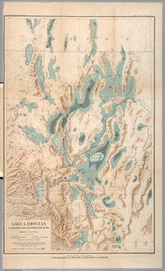
1885 Plate XLVI: Lake Lahontan : a quaternary … Geology Book Lake Lahontan : a quaternary lake of nor … |

1904 San Francisco. [Guide Book, Pocket Map] The commercial, pictorial and tourist ma … |

1886 Great Sunset Route Real Estate The Great Sunset Route. Shortest Line be … |

1886 Central & Southern Pacific railroads in … Real Estate Map of summer & winter resorts and other … |

1875 Topographical Sketch...Diversion of The … National Atlas Topographical Sketch showing the Outward … |

1897 Magnetic Ranges for San Francisco Bay. Pamphlet Treasury Department, U.S. Coast and Geod … |

1802 Carta Esferica de los Reconocimientos He … Exploration Book Carta Esferica de los Reconocimientos He … |

1802 Carta de los reconocimientos hechos en 1 … Exploration Book Carta de los reconocimientos hechos en 1 … |

1802 Plano del Puerto de S Diego. Exploration Book Plano del Puerto de S. Diego en la Costa … |

1802 Plano del Puerto y Bahia De Monte Rey. Exploration Book Plano del Puerto y Bahia De Monte Rey si … |

1866 Central California. Guide Book Central California. |

1866 Southern California. Guide Book Southern California. |

1866 Northern California. Guide Book Northern California. |

1893 Topographical Map Of The Yosemite Valley … National Atlas Topographical Map Of The Yosemite Valley … |