Who What Where WhenREMOVEWHERE
|
REFINE
Browse All : Book Map of California
1-47 of 47
Author
Blum, George W.
Full Title
Map of the Golden Gate Park, the Avenue and Buena Vista Park. 1895.
Publisher
Geo. W. Blum
Author
Blum, George W.
Full Title
Untitled map of Sonoma, Marin, Lake, and Napa Counties.
Publisher
Geo. W. Blum
Author
Blum, George W.
Full Title
(Untitled map of the South Bay including San Mateo, Santa Cruz, Santa Clara, Alameda, and Contra Costa Counties.)
Publisher
Geo. W. Blum
Author
Blum, George W.
Full Title
(Untitled map of the area around Sacramento and Marysville including Colusa, Yolo, Napa, Butte, Yuba, Sutter, Solano, and Sacramento Counties.)
Publisher
Geo. W. Blum
Author
Blum, George W.
Full Title
(Untitled map of the Central Coast area including San Benito, Fresno, Monterey, San Luis Obispo, Kings, Kern, and Santa Barbara Counties.)
Publisher
Geo. W. Blum
Author
Blum, George W.
Full Title
(Untitled map of the Central Valley area including Sacramento, Amador, Calaveras, San Joaquin, Tuolumne, Stanislaus, Merced, and Mariposa Counties.)
Publisher
Geo. W. Blum
Author
Blum, George W.
Full Title
(Untitled map of Southern California including Ventura, Los Angeles, San Bernardino, Orange, and San Diego Counties.)
Publisher
Geo. W. Blum
Author
Blum, George W.
Full Title
Map of California Roads for Cyclers. This Map Engraved by the California Photo-Eng. Co. Wasp B'ld'g., 513 Market St., S.F. Designed & Drawn by Geo. W. Blum. Edward Denny & Co. 207 Montgomery St. Sole Agents. Published and Copyrighted by Geo. W. Blum, San Francisco, Cal. (with) Inset map of the Los Angeles area.
Publisher
Geo. W. Blum
Author
Emory, William H.
Full Title
Military Reconnaissance Of The Arkansas Rio Del Norte And Rio Gila By W.H. Emory, Lieut. Top. Engrs. Assisted ... by J.W. Abert and W.G. Peck, and ... by W.H. Warner and Mr. Norman Bestor, Made in 1846-7, with the advance guard of the "Army of the West". Under Command Of Brig. Gen. Stephn. W. Kearny. Constructed under the orders of Col. J.J. Abert ... 1847. Drawn by Joseph Welch. Engraved on stone by E. Weber & Co. Baltimore.
Publisher
Wendell and Van Benthuysen
Author
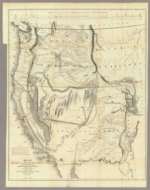
Fremont, J.C.
Full Title
Map Of An Exploring Expedition To The Rocky Mountains in the Year 1842, Oregon & North California In The Years 1843-44. By Brevet Capt. J. C. Fremont Of The Corps Of Topographical Engineers Under the orders of Col. J.J. Abert, Chief Of The Topographical Bureau. Lith. by E. Weber & Co. Baltimore, Md.
Publisher
Blair and Rives
Author
Fremont, J.C.
Full Title
Map Of Oregon And Upper California From the Surveys of John Charles Fremont And other Authorities. Drawn By Charles Preuss Under the Order of the Senate Of The United States, Washington City 1848. Lithy. by E. Weber & Co. Balto. (inset) Profile of the travelling route from the South Pass of the Rocky Mountains to the Bay of San Francisco.
Publisher
Wendell and Van Benthuysen
Author
[Eddy, William M., Jones, William Carey]
Full Title
Official Map of San Francisco, Compiled from the Field Notes of the Official Re-Survey made by William M. Eddy. Surveyor of the Town of San Francisco, California. 1849. S.W. Higgins. Draftn. Copied by P.M. McGill C.E. & Draftn. Washington. C.B. Graham lith. Washington, D.C.
Publisher
U.S.
Author
California State Board of Trade
Full Title
Map of California, prepared for the State Board of Trade, 1892 ... By the Elliot (sic) Pub. Co., S.F. (with) Map of section surrounding San Francisco. (with) Map showing Orange Co., and part of Los Angeles, San Bernardino and San Diego counties.
Publisher
California State Board of Trade
Author
California State Board of Trade
Full Title
Geographical, topographical and railroad map of California. Published by the California State Board of Trade, 1908. Copyrighted 1907.
Publisher
California State Board of Trade
Author
Williamson, R.S.
Full Title
From San Francisco Bay to the Northern Boundary of California from Explorations and Surveys made under the direction of the Hon. Jefferson Davis Secretary of War by Lieut. R.S. Williamson, U.S. Topl. Engrs. and Lieut. H.L. Abbot, U.S. Topl. Engrs., H.C. Fillebrown, J. Young and C.D. Anderson, Assts. 1855. Explorations and surveys for a railroad route from the Mississippi River to the Pacific Ocean. War Department. Routes in Oregon and California. Map No. 1. Drawn by John Young.
Publisher
[A.O.P. Nicholson I-XI, T. Ford XII.]
Author
[Abbot, Henry L., Williamson, R.S.]
Full Title
Routes in Oregon and California. Profiles sheet no. 1 from Benicia to Fort Reading and from Fort Reading to Vancouver; from explorations and surveys made under the direction of Hon. Jefferson Davis, Sec. of War by Lieut. R.S. Williamson, U.S. Topl. Engrs. and Lieut. H.L. Abbot, U.S. Topl. Engrs, H.C. Fillerbrown, C.D. Anderson and J. Young assts. 1855. (1861)
Publisher
[A.O.P. Nicholson I-XI, T. Ford XII.]
Author
[Abbot, Henry L., Williamson, R.S.]
Full Title
Routes in Oregon and California. Profiles sheet no. 2 from the head of Des Chutes Valley to Vancouver and from Vancouver to Fort Reading; from explorations and surveys made under the direction of Hon. Jefferson Davis, Sec. of War by Lieut. R.S. Williamson, U.S. Topl. Engrs. and Lieut. H.L. Abbot, U.S. Topl. Engrs, H.C. Fillerbrown, C.D. Anderson and J. Young assts. 1855. (1861)
Publisher
[A.O.P. Nicholson I-XI, T. Ford XII.]
Author
Beckwith, E.G.
Full Title
From the Mud Lakes to the Pacific Ocean; from Explorations and Surveys made under the direction of the Hon. Jefferson Davis Secretary of War by Capt. E.G. Beckwith, 3d. Artillery. F.W. Egloffstein, Topographer for the Route. 1855. Explorations and surveys for a railroad route from the Mississippi River to the Pacific Ocean. War Department. Route near the 41st Parallel. Map No. 4. Selmar Siebert's Engraving & Printing Establishment. Washington, D.C.
Publisher
[A.O.P. Nicholson I-XI, T. Ford XII.]
Author
[Ives, J.C., Whipple, A.W.]
Full Title
From the Rio Grande to the Pacific Ocean from explorations and surveys made under the direction of the Hon. Jefferson Davis, Secretary of War by Lieut. A.W. Whipple, Topogl. Engrs. and Lieut. J.C. Ives, Topogl. Engrs. A.H. Campbell, Civil Eng. and Surveyor, Asst. Surveyors: Wm. White Jr., N.H. Hutton, and J.P. Sherburne. 1853-4. Explorations and Surveys for a Rail Road Route from the Mississippi River to the Pacific Ocean, War Department, Route Near the 35th Parallel, Map No. 2. Engr. by Selmar Siebert. Drawn by John D. Hoffmann.
Publisher
[A.O.P. Nicholson I-XI, T. Ford XII.]
Author
Williamson, R.S.
Full Title
General Map of Explorations and Surveys in California made under the direction of the Hon. Jefferson Davis, Secretary of War by Lieut. R.S. Williamson, Topogl. Engr. assisted by Lieut. J.G. Parke, Topl. Engr. and Mr. Isaac Williams Smith, Civ. Engr. 1853. Explorations and Surveys for a Rail Road Route from the Mississippi River to the Pacific Ocean. War Department. Routes in California to connect with the routes near the 32nd and 35th parallels. Engr. by Selmar Siebert.
Publisher
[A.O.P. Nicholson I-XI, T. Ford XII.]
Author
Williamson, R.S.
Full Title
Map of Passes in the Sierra Nevada from Walker's Pass to the Coast Range: from Explorations and Surveys made under the direction of the Hon. Jefferson Davis, Secretary of War by Lieut. R.S. Williamson Topl. Engr. assisted by Lieut. J.G. Parke Topl. Engr. and Mr. Isaac Williams Smith, Civ. Engr. 1853. Explorations and Surveys for a Rail Road Route from the Mississippi River to the Pacific Ocean. War Department. Routes in California to connect with the routes near the 32nd and 35th parallels. Engraved by Selmar Siebert.
Publisher
[A.O.P. Nicholson I-XI, T. Ford XII.]
Author
Williamson, R.S.
Full Title
Map and Profile of the Canada de las Uvas; from Explorations and Surveys made under the direction of the Hon. Jefferson Davis, Secretary of War by Lieut. R.S. Williamson Topl. Engr. assisted by Lieut. J.G. Parke Topl. Engr. and Mr. Isaac Williams Smith, Civ. Engr. 1853. Explorations and Surveys for a Rail Road Route from the Mississippi River to the Pacific Ocean. War Department. Routes in California to connect with the routes near the 32nd and 35th parallels. Engr. by Selmar Siebert.
Publisher
[A.O.P. Nicholson I-XI, T. Ford XII.]
Author
Williamson, R.S.
Full Title
Map and Profile of the Tejon Pass; from Explorations and Surveys made under the direction of the Hon. Jefferson Davis, Secretary of War by Lieut. R.S. Williamson Topl. Engr. assisted by Lieut. J.G. Parke Topl. Engr. and Mr. Isaac Williams Smith, Civ. Engr. 1853. Explorations and Surveys for a Rail Road Route from the Mississippi River to the Pacific Ocean. War Department. Routes in California to connect with the routes near the 32nd and 35th parallels. Engr. by Selmar Siebert.
Publisher
[A.O.P. Nicholson I-XI, T. Ford XII.]
Author
Williamson, R.S.
Full Title
Sheet no. 1. Profiles of passes in the Sierra Nevada; from Explorations and Surveys made under the direction of the Hon. Jefferson Davis, Secretary of War by Lieut. R.S. Williamson, Topl. Engr. assisted by Lieut. J.G. Parke, Topl. Engr. and Mr. Isaac Williams Smith, Civ. Engr. 1853. Explorations and Surveys for a Rail Road Route from the Mississippi River to the Pacific Ocean. War Department. Routes in California to connect with the routes near the 32nd and 35th parallels. (1861)
Publisher
[A.O.P. Nicholson I-XI, T. Ford XII.]
Author
Williamson, R.S.
Full Title
Sheet no. 2. Profiles of passes in the Sierra Nevada; from Explorations and Surveys made under the direction of the Hon. Jefferson Davis, Secretary of War by Lieut. R.S. Williamson, Topl. Engr. assisted by Lieut. J.G. Parke, Topl. Engr. and Mr. Isaac Williams Smith, Civ. Engr. 1853. Explorations and Surveys for a Rail Road Route from the Mississippi River to the Pacific Ocean. War Department. Routes in California to connect with the routes near the 32nd and 35th parallels. (1861)
Publisher
[A.O.P. Nicholson I-XI, T. Ford XII.]
Author
Parke, John G.
Full Title
From San Francisco Bay to the Plains of Los Angeles from Explorations and Surveys made under the direction of The Hon. Jefferson Davis, Secretary of War by Lieut. John G. Parke, Topl. Engrs. assisted by Albert H. Campbell, Civil Engineer and N.H. Hutton, H. Custer and G.G. Garner. 1854 & 55. Map No. 1. Constructed and drawn by H. Custer. Explorations and Surveys for a Rail Road Route from the Mississippi River to the Pacific Ocean. War Department. Coast Route, California.
Publisher
[A.O.P. Nicholson I-XI, T. Ford XII.]
Author
Parke, John G.
Full Title
From the Pimas Villages to Fort Fillmore from Explorations and Surveys made under the direction of The Hon. Jefferson Davis, Secretary of War by Lieut. John G. Parke, Topl. Engrs. assisted by Albert H. Campbell, Civil Engineer and N.H. Hutton, H. Custer and G.G. Garner. 1854 & 55. Map No. 2. Engr. by Selmar Siebert. Explorations and Surveys for a Rail Road Route from the Mississippi River to the Pacific Ocean. War Department. Route near the 32nd parallel of North Latitude.
Publisher
[A.O.P. Nicholson I-XI, T. Ford XII.]
Author
Parke, John G.
Full Title
Profiles from San Francisco Bay to Los Angeles, Cala. and from the Pimas Villages to Fort Fillmore from Explorations and Surveys made under the direction of The Hon. Jefferson Davis, Secretary of War by Lieut. John G. Parke, Topl. Engrs., assisted by Albert H. Campbell, Civil Engineer and N.H. Hutton, H. Custer and G.G. Garner, assts. 1854 & 55. Explorations and Surveys for a Rail Road Route from the Mississippi River to the Pacific Ocean. War Department. Route near the 32d parallel & coast route, Cala.
Publisher
[A.O.P. Nicholson I-XI, T. Ford XII.]
Author
Leahy, J.F.
Full Title
Leahy's Hotel Guide and Railway Distance Map of the State of California. Published by American Hotel Register Company. Leahy Build., 228-234 W. Ontario St., Chicago, Ill. Copyrighted by J.F. Leahy, Jan., 1934. (untitled insets of) San Francisco Bay Area, and Los Angeles and environs.
Publisher
American Hotel register Co.
Author
Langley, Henry G.
Full Title
Map Of San Francisco From the Latest Survey. Engraved Expressly For The San Francisco Directory. 1870. Lith. Britton & Rey S.F. (with) A Map And Street Directory Of San Francisco: To Which Are Added Many Items ... Useful For Strangers Visiting The Metropolis of the Pacific. Price Seventy-Five Cents. San Francisco: Henry G. Langley, 612 Clay St. 1870. (on verso) Entered ... 1870, By Henry G. Langley ... California.
Publisher
Henry G. Langley
Author
Faust, H.W.
Full Title
Faust's Map & Guide Of San Francisco. Published by H.W. Faust. Entered by H.W. Faust ... Washington, D.C., June 1882. Galloway Litho. Co., 422 Commercial St., S.F. Compiled By P. Spitze. C.E. (inset) Map Of The City & County Of San Francisco. (inset) General View Of San Francisco Bay.
Publisher
H.W. Faust
Author
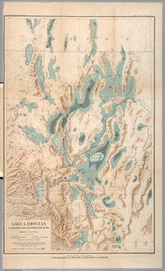
Russell, Israel C. (Israel Cook), 1852-1906.
Full Title
Post - quaternary fault lines. Julius Bien & Co. Lith. (to accompany) Geological history of Lake Lahontan : a quaternary lake of Northwestern Nevada. (series title) Department of Interior : Monographs of the United States Geological Survey, vol. XI. (on upper margin) U.S. Geological Survey; Lake Lahontan PL. XLIV.
Publisher
U.S. Govt. Print Office
Author
Russell, Israel C. (Israel Cook), 1852-1906.
Full Title
Lake Lahontan : a quaternary lake of northwestern Nevad, by Israel C. Russell. Assisted by A.L. Webster, W.D. Johnson, cartographers ; W.J. McGee. GEO. M. Wright, geologists. Mountain shading, by W.J. Hays. Topography compiled by Eugene Rickseker ... (to accompany) Geological history of Lake Lahontan : a quaternary lake of Northwestern Nevada. (series title) Department of Interior : Monographs of the United States Geological Survey, vol. XI. (on upper margin) U.S. Geological Survey; Lake Lahontan PL. XLVI.
Publisher
U.S. Govt. Print Office
Author
Chevalier, August
Full Title
The commercial, pictorial and tourist map of San Francisco, in colors and illustrated with litho-engraved pictures of all public buildings, parks, monuments, and recommended business houses, etc. Designed, engraved & copyrighted by Aug. Chevalier. Copyrighted 15th Dec. 1903 by Aug. Chevalier. 1st edition, 1904, August. Galloway Litho Co., S.F.
Publisher
Aug. Chevalier
Author
Southern Pacific Company
Full Title
The Great Sunset Route. Shortest Line between the Atlantic and the Pacific Oceans... Boston Agency: 192 Washington Street 192. General Eastern Agency: New York city, 339 Broadway. (with) Map of summer & winter resorts and other places upon and near the Central & Southern Pacific railroads in California. D. Van Vleck S.F. Eng. F.T. Newbery Del. (with catalog) A List of Government And Railroad Lands in California, Open to Preemption or Homestead or to Purchase. Southern Pacific Company, New Orleans to San Francisco Via the Sunset Route. With Complements of the New York General Agency. 339 Broadway. L.H. Nutting, Eastern passenger Agent. E. Hawley, Genl. Eastern Agent.
Publisher
Southern Pacific Company
Author
Southern Pacific Company
Full Title
Map of summer & winter resorts and other places upon and near the Central & Southern Pacific railroads in California. D. Van Vleck S.F. Eng. F.T. Newbery Del. (with map)The Great Sunset Route. Shortest Line between the Atlantic and the Pacific Oceans... Boston Agency: 192 Washington Street 192. General Eastern Agency: New York city, 339 Broadway. (with catalog) A List of Government And Railroad Lands in California, Open to Preemption or Homestead or to Purchase. Southern Pacific Company, New Orleans to San Francisco Via the Sunset Route. With Complements of the New York General Agency. 339 Broadway. L.H. Nutting, Eastern passenger Agent. E. Hawley, Genl. Eastern Agent.
Publisher
Southern Pacific Company
Author
[Wheeler, G.M., Bergland, Eric]
Full Title
Topographical Sketch showing the Outward and Inward Route of a Party, while examining as to the practicability of a Diversion of the Colorado River for Purposes of Irrigation... 1875. Geographical Surveys West Of The 100th Meridian.
Publisher
U.S.
Author
U.S. Coast Survey
Full Title
Treasury Department, U.S. Coast and Geodetic Survey, Magnetic Ranges for Compass Deviation, San Francisco Bay, California. Published December, 1897, Henry S. Pritchett, Superintendent. Verified: O.H. Tittmann, Assistant ... E.D. Taussig, Lieut. Comdr., U.S.N., Hydrographic Inspector. A.R. Graham Photo. Lith. Washington D.C.
Publisher
Government Printing Office
Author
Espinosa y Tello, J.
Full Title
Carta Esferica de los Reconocimientos Hechos en la Costa N.O. De America en 1791 y 92 por las Goletas Sutil y Mexicana, y otros Buques de S.M. Cardano lo grabo. Morata lo escribio. Numero 1.
Publisher
Imprenta Real
Author
[Espinosa y Tello, J., Martinez de Palacios, Geronimo]
Full Title
Carta de los reconocimientos hechos en 1602. Por el Capitan Sebastian Vizcayno Formada por los Planos que hizo el mismo durante su comision. Numo. 4. Cardano lo grabo.
Publisher
Imprenta Real
Author
Espinosa y Tello, J.
Full Title
Plano del Puerto de S. Diego en la Costa Setentl. de Californs. Levantado por el 2o. Piloto de la Armada D. Juan Pantoja. Ano 1782. Numo. 5. Cardano lo grabo. Morata lo escr.
Publisher
Imprenta Real
Author
Espinosa y Tello, J.
Full Title
Plano del Puerto y Bahia De Monte Rey situado en la Costa de Californs. Tabajado a bordo de las Corvetas Descubierta y Atrevida. Ano 1791. Cardano lo grabo. Morata lo escribio. Numo. 6.
Publisher
Imprenta Real
Author
Holdredge, Sterling M.
Full Title
Central California.
Publisher
S.M. Holdredge
Author
Holdredge, Sterling M.
Full Title
Southern California.
Publisher
S.M. Holdredge
Author
Holdredge, Sterling M.
Full Title
Northern California.
Publisher
S.M. Holdredge
Author
U.S. Department of the Interior
Full Title
Topographical Map Of The Yosemite Valley And Vicinity. Part Of East Central California. Mountain Drawing by J.E. Weyss; Lettering by J. Franke. From Topographical Plat by Lt. Macomb, Nov. 30, 1883. The Norris Peters Co. Photo-Litho., Washington, D.C. Expeditions Of 1878-79, Under the Command of Capt. Geo. M. Wheeler, Corps of Engineers, U.S. Army. U.S. Geographical Surveys West Of The 100th Meridian. (Printed in red above border) Yosemite State Park, showing toll roads leading into.
Publisher
U.S.
1-47 of 47
|