Who What Where WhenREMOVEWHO
WHEN
|
Author
Tanner, Henry S.
Full Title
The Traveller's Guide or Map Of The Roads, Canals & Rail Roads of the United States. With the distances from place to place by H.S. Tanner." On bottom of map: "Entered ... 1834, by H.S. Tanner ... Pennsylvania. (to accompany) The American Traveller; Or Guide Through the United States. Containing Brief Notices of the Several States, Cities, Principal Towns ... With tables of Distances, ... Second Edition. By H.S. Tanner. Philadelphia: Published by the Author, Shakespeare Buildings. 1836. (on verso) Entered ... 1836, By H.S. Tanner ... Pennsylvania.
Publisher
H.S. Tanner
Author
Tanner, Henry S.
Full Title
The Traveller's Guide or Map Of The Roads, Canals & Rail Roads of the United States. With the distances from place to place by H.S. Tanner. " On bottom of map: "Published by H.S. Tanner. Entered ... 1834, by H.S. Tanner ... Pennsylvania. (to accompany) The American Traveller; Or Guide Through the United States. Containing Brief Notices of the Several States, Cities, Principal Towns ... By H.S. Tanner. Philadelphia: Published by the Author, Shakespeare Buildings. 1834. (on verso) Entered ... 1834, by H.S. Tanner ... Pennsylvania.
Publisher
H.S. Tanner
Author
Warren, Gouverneur Kemble, 1830-1882
Full Title
Map Of The Territory Of The United States From The Mississippi To The Pacific Ocean Ordered by the Hon. Jeff'n Davis, Secretary Of War To accompany the Reports of the Explorations For A Railroad Route ... Compiled from authorized explorations and other reliable data by Lieut. G.K. Warren, Topl. Engrs. In the Office of Pacific R.R. Surveys, War Dep. under the direction of Bvt. Maj. W.H. Emory, Topl Engrs. in 1854 and of Capt. A.A. Humphreys, Topl. Engrs. 1854-5-6-7. Engr. by Selmar Siebert.
Publisher
[A.O.P. Nicholson I-XI, T. Ford XII.]
Author
Powell, John Wesley, 1834-1902.
Full Title
Sketch of Black Rock and vicinity, Utah Territory, Prepared to show the position of the graduated pillar erected by Dr. John Park for observation on the water-level of Great Salt Lake, and the position of the granite bench-mark. (to accompany) Report on the Lands of the Arid Region of the United States, with a More Detailed Account of the Lands of Utah. With Maps. By J.W. Powell. Second edition. Washington: Government Printing Office. 1879.
Publisher
Government Printing Office
Author
Powell, John Wesley, 1834-1902.
Full Title
Comparative map of Great Salt Lake, Utah : compiled to show its increase of area ... (to accompany) Report on the Lands of the Arid Region of the United States, with a More Detailed Account of the Lands of Utah. With Maps. By J.W. Powell. Second edition. Washington: Government Printing Office. 1879.
Publisher
Government Printing Office
Author
Powell, John Wesley, 1834-1902.
Full Title
Map of Utah territory : representing the extent of the irrigable, timber and pasture lands ; compiled and drawn by Charles Mahon, J.H. Renshawe, W.H. Graves and H. Lindenkohl for the Commissioner of Public Lands. (at head of title) Department of the Interior, U.S. Geographical and Geological Survey of the Rocky Mountain region, J.W. Powell in charge. (on upper margin) To accompany report on the Lands of the Arid Region of the U.S.
Publisher
Government Printing Office
Author
Powell, John Wesley, 1834-1902.
Full Title
Map of the United States exhibiting the grants of lands made by the general government to aid in the construction of railroads and wagon roads. For explanation see chapter on "L̀and grants in aid of internal improvements". Julius Bien, Lithographer. (at head of title) Department of the Interior, U.S. Geographical and Geological Survey of the Rocky Mountain region, J.W. Powell in charge. (on upper margin) To accompany report on the Lands of the Arid Region of the U.S.
Publisher
Government Printing Office
Author
Powell, John Wesley, 1834-1902.
Full Title
Rain chart of the United States : showing by isohyetal lines the distribution of the mean annual precipitation in rain and melted snow. This is a copy of the chart constructed for the Smithsonian Institution in 1868 by Charles A Schott ... Julius Bien, Lithographer. (at head of title) Department of the Interior, U.S. Geographical and Geological Survey of the Rocky Mountain region, J.W. Powell in charge. (on upper margin) To accompany report on the Lands of the Arid Region of the U.S.
Publisher
Government Printing Office
Author
Whitney, Asa
Full Title
No. 2 ( A map of North America showing possible rail routes across the continent.) Miller's Lith. 102 Broadway, N.Y. "N.B. this map shews very nealy the sphere of the Globe, and the line from Baltimore and the line from Panama to Puget Sound, would be the air line route. (to accompany) A Project For A Railroad To The Pacific. By Asa Whitney, of New York.
Publisher
George W. Wood
Author
Tanner, Henry S.
Full Title
Profile of the Erie Canal N.Y. ; Profile of the Ohio Canal ; Profile of the Chesapeake & Ohio Canal. (with inset profile) Baltimore & Ohio railroad. (to accompany) A Description of the Canals and Railroads of the United States.
Publisher
T.R. Tanner & J. Disturnell
Author
Tanner, Henry S.
Full Title
Florida Canal ; Morris Canal N. J. ; Union Canal Pa. ; Schuylkill Navigation Penn. ; Profile of the Pennsylvania Canal. (with inset profile) Columbia railroad Pa. (to accompany) A Description of the Canals and Railroads of the United States.
Publisher
T.R. Tanner & J. Disturnell
Author
Tanner, Henry S.
Full Title
Map of the canals & railroads of the United States, reduced from the large map of the U.S. by H. S. Tanner. Published T. R. Tanner & J. Disturnell, 124 Broadway, New York, 1840. Engraved by J. Knight. Entered ... 1840, by T.R. Tanner ... Pennsylvania. ( inset continuation map of ) South part of Florida ; Chesapeake & Delaware Canal ; Dismal Swamp Canal ; Welland Canal ; Lehigh navigation.
Publisher
T.R. Tanner & J. Disturnell
Author
Blodget, Lorin
Full Title
Isothermal chart: Mean distribution of heat for the Winter on the North American Continent; between 25 (degrees) and 50 (degrees) N. Lat. By Lorin Blodget. Fred Bourquin & Co., 50 S. 3rd. St. Phila. (to accompany) Climatology of the United States ...1857.
Publisher
J.B. Lippincott
Author
Blodget, Lorin
Full Title
Isothermal chart: Mean distribution of heat for the year on the North American Continent; between 25 (degrees) and 50 (degrees) N. Lat. By Lorin Blodget. Fred Bourquin & Co., 50 S. 3rd. St. Phila. (to accompany) Climatology of the United States ...1857.
Publisher
J.B. Lippincott
Author
Blodget, Lorin
Full Title
Hyetal or rain chart: Mean distribution of rain for the Spring on the North American Continent; between 25 (degrees) and 50 (degrees) N. Lat. By Lorin Blodget. Fred Bourquin & Co., 50 S. 3rd. St. Phila. (to accompany) Climatology of the United States ...1857.
Publisher
J.B. Lippincott
Author
Blodget, Lorin
Full Title
Hyetal or rain chart: Mean distribution of rain for the Summer on the North American Continent; between 25 (degrees) and 50 (degrees) N. Lat. By Lorin Blodget. Fred Bourquin & Co., 50 S. 3rd. St. Phila. (to accompany) Climatology of the United States ...1857.
Publisher
J.B. Lippincott
Author
Blodget, Lorin
Full Title
Hyetal or rain chart: Mean distribution of rain for the Autumn on the North American Continent; between 25 (degrees) and 50 (degrees) N. Lat. By Lorin Blodget. Fred Bourquin & Co., 50 S. 3rd. St. Phila. (to accompany) Climatology of the United States ...1857.
Publisher
J.B. Lippincott
Author
Blodget, Lorin
Full Title
Hyetal or rain chart: Mean distribution of rain for the Winter on the North American Continent; between 25 (degrees) and 50 (degrees) N. Lat. By Lorin Blodget. Fred Bourquin & Co., 50 S. 3rd. St. Phila. (to accompany) Climatology of the United States ...1857.
Publisher
J.B. Lippincott
Author
Blodget, Lorin
Full Title
Hyetal or rain chart: Mean distribution of rain for the year on the North American Continent; between 25 (degrees) and 50 (degrees) N. Lat. By Lorin Blodget. Fred Bourquin & Co., 50 S. 3rd. St. Phila. (to accompany) Climatology of the United States ...1857.
Publisher
J.B. Lippincott
Author
Whitney, Asa.
Full Title
(Map, without a title, United States and northern Mexico). Drawn & engraved by O.H. Throop. (to accompany) Memorial of A. Whitney, Praying A grant of public land to enable him to construct a railroad from lake Michigan to the Pacific Ocean. February 24, 1846. [Senate.] 29th Congress, 1st Session. [161].
Publisher
Ritchie & Heiss
Author
[King, Clarence, U.S. Geological Survey]
Full Title
Map Showing Geographical Divisions of the U.S. Geological Survey, 1880. Department of Interior U.S. Geological Survey, Clarence King, Director. Julius Bien, Lith, N.Y. (to accompany) First Annual Report of the United States Geological Survey. To the Hon. Carl Schurz, Secretary of the Interior. By Clarence King, Director. Washington: Government Printing Office. 1880.
Publisher
Government Printing Office
Author
Jefferys, Thomas
Full Title
A map of Canada and the north part of Louisiana with the adjacent countrys. By Thos. Jefferys, Geographer to His Royal Highness the Prince of Wales. T. Jefferys sculp. (1760)
Publisher
Thomas Jefferys
Author
[Anville, Jean Baptiste Bourguignon d, 1697-1782, Jefferys, Thomas]
Full Title
North America from the French of Mr. d'Anville, improved with the back settlements of Virginia and course of Ohio. Illustrated with geographical and historical remarks. 1755 published according to Act by Thos. Jefferys Geographer to His Royal Highness the Prince of Wales near Charing Cross. (1760)
Publisher
Thomas Jefferys
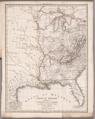
Author
[Poirson, J.B., Herbin de Halle, Etienne de.]
Full Title
Cours du Mississippi comprenant la Louisiane, les 2 Florides, une partie des Etats-Unis et pays adjacents. Par J. B. Poirson, ingenieur geographe ; Nivose An XI (1803), grave par Tardieu l'aine rue de Sorbonne, no. 385. (on upper right margin) No.XVIII. (to accompany) Statistique Generale et Particuliere De La France et De Ses Colonies, avec une Nouvelle Description ... 1804.
Publisher
F. Buisson
Author
Smith, J. Calvin
Full Title
A New Map For Travellers Through the United States Of America Showing the Railroads, Canals & Stage Roads. With The Distances, by J. Calvin Smith. Published by J. Calvin Smith, New-York. MDCCCLVI. Entered ... 1856, by J. Calvin Smith ... New York. (inset) Map Of Oregon Northern California Santa Fe &c. (& 4 additional inset maps). (to accompany) Smith's Hand-Book For Travelers Through The United States Of America.
Publisher
J. Calvin Smith & Son
Author
New York Central Railroad Company
Full Title
Map of the New York Central Lines ... The Matthews-Northrup Works, Buffalo, N.Y.
Publisher
Rand McNally
Author
Gilpin, William
Full Title
Map Illustrating the System of the Parcs, and the Domestic Relations of the "Great Plains," the "North American Andes," and the Pacific Maritime Front."
Publisher
J.B. Lippincott & Co.
Author
[Colles, Christopher, Ristow, W. editor]
Full Title
Index to the Plates in Christopher Colles' Survey of the Roads of the United States of America. (using the) Map of the Middle States Exhibiting the Post Roads c. 1790 after Evans, Bowles and Bradley.
Publisher
Harvard Un. Press
Author
Tanner, Henry S.
Full Title
A Connected View of The Whole Internal Navigation of the United States; ... Corrected and Improved From the Edition of 1826, And Much Enlarged, ... With A Sheet Map, ... The Map Has Been Engraved For the Purpose ... On A Reduced Scale, From Tanner's Excellent Four Sheet Map of the United States, Recently Published. ... By a Citizen of the United States. Philadelphia: Published by the Author ... Printed by Lydia R. Bailey. 1830. (on verso) ...on the seventeenth day of April ... 1830, George Armroyd ... hath deposited ... a Book ... Pennsylvania.
Publisher
George Armroyd
Author
[Butterfield, Carlos, Johnson & Browning]
Full Title
United States and Mexican Mail Steamship Line, and Statistics of Mexico. By Carlos Butterfield, Washington. December, 1859. New York: J.A.H. Hasbrouck & Co., Printers ... 1860. (on verso) Entered ... 1859, by Carlos Butterfield ... New York. (With) Map of the United States and Mexico Published by Johnson & Browning under the direction of Col. Carlos Butterfield. December 1859.
Publisher
J.A.H. Hasbrouck & Co.
Author
[Mitchell, John, Raynal, G.T., Zatta, Antonio]
Full Title
Il Canada, Le Colonie Inglesi Con La Luigiana, e Florida. di nuova Projezione. Venezia 1778. Presso Antonio Zatta Con Privilegio dell'Eccmo Senato. G. Zuliani inc.
Publisher
Antonio Zatta
Author
Melish, John
Full Title
United States of America. Compiled from the latest & best authorities by John Melish, 1820. Engraved by Saml. Harrison. Entered ... 10th July 1818, and published by John Melish, Philadelphia, improved to 1822.
Publisher
John Melish
Author
Melish, John
Full Title
A diagram of the United States shewing the bearings and distances of the principal places from Washington, and from each other, with a scale of time. Prepared for the Travellers directory by John Melish. (Philadelphia: Published by the Author. 1822)
Publisher
John Melish
Author
Carver, Jonathan
Full Title
A New Map of North America, From the Latest Discoveries. 1778. Engrav'd for Carvers Travels.
Publisher
C. Dilly
Author
Melish, John
Full Title
Map of the United States of America. J. Melish del. H.S. Tanner Sc.
Publisher
Palmer, Thomas & George
Author
[Birkbeck, Morris, Melish, John]
Full Title
United States. Published 1st June 1816 by J. Melish. Philadelphia. Improved to 1818.
Publisher
M. Carey & Son
Author
Maclure, William
Full Title
A Map of the United States of America. By Samuel G. Lewis.
Publisher
C. & A. Conrad
Author
Bromme, Traugott
Full Title
Die Vereinigten Staaten von Nord-America. Entworfen von J.E. Woerl. Lithographie von B. Herder in Freiburg im Breisgau.
Publisher
Buchner
Author
Gallatin, Albert
Full Title
Map of the Indian Tribes of North America about 1600 A.D. along the Atlantic; & about 1800 A.D. westwardly. Published by the Amer: Antiq: Soc: From a drawing by Hon: A. Gallatin.
Publisher
The University Press
Author
Maclure, William
Full Title
Map of the United States of America. J. Melish del. Designed to illustrate the Geological Memoir of Wm. Maclure Esqr. Transactions American Philosophical Society, Vol. I. New Series. Entered ... and Published by John Melish, Philadelphia.
Publisher
A. Small
Author
Maclure, William
Full Title
United States of North America.
Publisher
A. Small
|