Who What Where WhenREMOVEWHERE
|
Author
Tanner, Henry S.
Full Title
Hudson River and Vicinity. (engraved by) Stiles, S. & Co. N.Y. Published by T.R. Tanner ... New York, 1844. Entered ... 1834, by J. Disturnell ... New York. (to accompany ) The Traveller's Hand Book for the State of New York, The Province of Canada, and Parts of the Adjoining States ... By Which Every Interesting Object on the Leading Routes is Brought into View. With Maps, Etc. Third Edition. By H.S. Tanner. New York: Published at the Geographical Establishment ... 1845. (on verso) Entered ... 1843, by H.S. Tanner ... New York.
Publisher
H.S. Tanner
Author
Langley, Henry G.
Full Title
Map Of San Francisco From the Latest Survey. Engraved Expressly For The San Francisco Directory. 1870. Lith. Britton & Rey S.F. (with) A Map And Street Directory Of San Francisco: To Which Are Added Many Items ... Useful For Strangers Visiting The Metropolis of the Pacific. Price Seventy-Five Cents. San Francisco: Henry G. Langley, 612 Clay St. 1870. (on verso) Entered ... 1870, By Henry G. Langley ... California.
Publisher
Henry G. Langley
Author
Tanner, Henry S.
Full Title
The Traveller's Guide or Map Of The Roads, Canals & Rail Roads of the United States. With the distances from place to place by H.S. Tanner." On bottom of map: "Entered ... 1834, by H.S. Tanner ... Pennsylvania. (to accompany) The American Traveller; Or Guide Through the United States. Containing Brief Notices of the Several States, Cities, Principal Towns ... With tables of Distances, ... Second Edition. By H.S. Tanner. Philadelphia: Published by the Author, Shakespeare Buildings. 1836. (on verso) Entered ... 1836, By H.S. Tanner ... Pennsylvania.
Publisher
H.S. Tanner
Author
Tanner, Henry S.
Full Title
New York. (to accompany) The American Traveller; Or Guide Through the United States. Containing Brief Notices of the Several States, Cities, Principal Towns ... With tables of Distances, ... Second Edition. By H.S. Tanner. Philadelphia: Published by the Author, Shakespeare Buildings. 1836. (on verso) Entered ... 1836, By H.S. Tanner ... Pennsylvania.
Publisher
H.S. Tanner
Author
Tanner, Henry S.
Full Title
Boston. (to accompany) The American Traveller; Or Guide Through the United States. Containing Brief Notices of the Several States, Cities, Principal Towns ... With tables of Distances, ... Second Edition. By H.S. Tanner. Philadelphia: Published by the Author, Shakespeare Buildings. 1836. (on verso) Entered ... 1836, By H.S. Tanner ... Pennsylvania.
Publisher
H.S. Tanner
Author
Tanner, Henry S.
Full Title
Baltimore (to accompany) The American Traveller; Or Guide Through the United States. Containing Brief Notices of the Several States, Cities, Principal Towns ... With tables of Distances, ... Second Edition. By H.S. Tanner. Philadelphia: Published by the Author, Shakespeare Buildings. 1836. (on verso) Entered ... 1836, By H.S. Tanner ... Pennsylvania.
Publisher
H.S. Tanner
Author
Tanner, Henry S.
Full Title
(Views to) Breed's Hill, From Buncker Hill. D.C. Johnston. Del. J.W. Steel Sculp. And, Mauch Chunk. Underwood. J.W. Steel Sculp. (to accompany) The American Traveller; Or Guide Through the United States. Containing Brief Notices of the Several States, Cities, Principal Towns ... With tables of Distances, ... Second Edition. By H.S. Tanner. Philadelphia: Published by the Author, Shakespeare Buildings. 1836. (on verso) Entered ... 1836, By H.S. Tanner ... Pennsylvania.
Publisher
H.S. Tanner
Author
Faust, H.W.
Full Title
Faust's Map & Guide Of San Francisco. Published by H.W. Faust. Entered by H.W. Faust ... Washington, D.C., June 1882. Galloway Litho. Co., 422 Commercial St., S.F. Compiled By P. Spitze. C.E. (inset) Map Of The City & County Of San Francisco. (inset) General View Of San Francisco Bay.
Publisher
H.W. Faust
Author
Clason Map Company
Full Title
Clason's Guide Map Of Denver Colorado. Published By The Clason Map Co. Chicago, Ill. Denver, Colo. Copyrighted By the Clason Map Co. Denver, Colo. (inset map) Denver Business District. (with guide book) Clason's Denver Green Guide. The Clason Map Co. Chicago - Denver. New Census Edition 35 (cents).
Publisher
Clason Map Co.
Author
Disturnell, John
Full Title
Map Of The State of New York With the Latest Improvements
Publisher
J. Disturnell
Author
Disturnell, John
Full Title
Hudson River and Vicinity.
Publisher
J. Disturnell
Author
Disturnell, John
Full Title
Miniature Plan of the City of New-York. Engraved by J.F. Morin. 1836.
Publisher
J. Disturnell
Author
Tanner, Henry S.
Full Title
The Traveller's Guide or Map Of The Roads, Canals & Rail Roads of the United States. With the distances from place to place by H.S. Tanner. " On bottom of map: "Published by H.S. Tanner. Entered ... 1834, by H.S. Tanner ... Pennsylvania. (to accompany) The American Traveller; Or Guide Through the United States. Containing Brief Notices of the Several States, Cities, Principal Towns ... By H.S. Tanner. Philadelphia: Published by the Author, Shakespeare Buildings. 1834. (on verso) Entered ... 1834, by H.S. Tanner ... Pennsylvania.
Publisher
H.S. Tanner
Author
Tanner, Henry S.
Full Title
Philadelphia and Environs. (to accompany) The American Traveller; Or Guide Through the United States. Containing Brief Notices of the Several States, Cities, Principal Towns ... By H.S. Tanner. Philadelphia: Published by the Author, Shakespeare Buildings. 1834. (on verso) Entered ... 1834, by H.S. Tanner ... Pennsylvania.
Publisher
H.S. Tanner
Author
Tanner, Henry S.
Full Title
New York (to accompany) The American Traveller; Or Guide Through the United States. Containing Brief Notices of the Several States, Cities, Principal Towns ... By H.S. Tanner. Philadelphia: Published by the Author, Shakespeare Buildings. 1834. (on verso) Entered ... 1834, by H.S. Tanner ... Pennsylvania.
Publisher
H.S. Tanner
Author
Tanner, Henry S.
Full Title
Boston (to accompany) The American Traveller; Or Guide Through the United States. Containing Brief Notices of the Several States, Cities, Principal Towns ... By H.S. Tanner. Philadelphia: Published by the Author, Shakespeare Buildings. 1834. (on verso) Entered ... 1834, by H.S. Tanner ... Pennsylvania.
Publisher
H.S. Tanner
Author
Tanner, Henry S.
Full Title
Baltimore (to accompany) The American Traveller; Or Guide Through the United States. Containing Brief Notices of the Several States, Cities, Principal Towns ... By H.S. Tanner. Philadelphia: Published by the Author, Shakespeare Buildings. 1834. (on verso) Entered ... 1834, by H.S. Tanner ... Pennsylvania.
Publisher
H.S. Tanner
Author
Warren, Gouverneur Kemble, 1830-1882
Full Title
Reconnoissances in the Dacota Country By G.K. Warren, Lieut: Topl. Engrs. U.S.A. ... P.S. Duval & Co. Lith. Philada. (profile) Profile Of Route From Fort Pierre To Fort Kearney ... 1855.
Publisher
A.O.P. Nicholson, Senate Printer
Author
Warren, Gouverneur Kemble, 1830-1882
Full Title
Map Of The Territory Of The United States From The Mississippi To The Pacific Ocean Ordered by the Hon. Jeff'n Davis, Secretary Of War To accompany the Reports of the Explorations For A Railroad Route ... Compiled from authorized explorations and other reliable data by Lieut. G.K. Warren, Topl. Engrs. In the Office of Pacific R.R. Surveys, War Dep. under the direction of Bvt. Maj. W.H. Emory, Topl Engrs. in 1854 and of Capt. A.A. Humphreys, Topl. Engrs. 1854-5-6-7. Engr. by Selmar Siebert.
Publisher
[A.O.P. Nicholson I-XI, T. Ford XII.]
Author
[Ludlow, William, 1843-1901, United States. Army. Corps of Engineer]
Full Title
A geological map of the Black Hills: by Professor N.H. Winchell to accompany the report of Capt. William Ludlow U.S. Engineers. (to accompany) Report of a reconnaissance of the Black Hills of Dakota, made in the summer of 1874. By William Ludlow, Captain of Engineers, Bvt. Lieut. Colonel, U. S. Army; Chief Engineer Department of Dakota. Washington : Government Printing Office. 1875.
Publisher
Government Printing Office
Author
[Ludlow, William, 1843-1901, United States. Army. Corps of Engineer]
Full Title
Map of a reconnaissance of the Black Hills of Dakota, July and August 1874. With troops under command of Lt. Col. G.A.Custer, 7th., Cavalry, by Capt. Wm. Ludlow, Corps of Engineers. (on upper margin) Brig. Genl. A.A.Humphreys, Chief of Engineers U.S.A. ; Brig. Genl. A.H. Terry Comdg. Department. (to accompany) Report of a reconnaissance of the Black Hills of Dakota, made in the summer of 1874. By William Ludlow, Captain of Engineers, Bvt. Lieut. Colonel, U. S. Army; Chief Engineer Department of Dakota. Washington : Government Printing Office. 1875.
Publisher
Government Printing Office
Author
[Ludlow, William, 1843-1901, United States. Army. Corps of Engineer]
Full Title
Map of the Black Hills from a reconnaissance by Capt. Wm. Ludlow, Corps of Engineers. 1874, and map of Warren and Raynolds. Drawn by Sergt. C. Becker. (to accompany) Report of a reconnaissance of the Black Hills of Dakota, made in the summer of 1874. By William Ludlow, Captain of Engineers, Bvt. Lieut. Colonel, U. S. Army; Chief Engineer Department of Dakota. Washington : Government Printing Office. 1875.
Publisher
Government Printing Office
Author
Ludlow, William
Full Title
Judith Basin : drawn under the direction of Capt. W. Ludlow Corps of Engineers, to accompany his report. N. Peters, Photo Lithographer, Washington, D.C. (to accompany) Report of a Reconnaissance From Carroll, Montana Territory, on the Upper Missouri, to the Yellowstone National Park, and Return Made in the Summer of 1875, by William Ludlow ... Washington: Government Printing Office. 1876.
Publisher
[N. Peters, Government Printing Office]
Author
Ludlow, William
Full Title
Upper Geyser Basin : drawn under the direction of Capt. W. Ludlow Corps of Engineers, to accompany his report. Complied and drawn by Ch. Becker, Sergt. U.S.E. N. Peters, Photo Lithographer, Washington, D.C. (to accompany) Report of a Reconnaissance From Carroll, Montana Territory, on the Upper Missouri, to the Yellowstone National Park, and Return Made in the Summer of 1875, by William Ludlow ... Washington: Government Printing Office. 1876.
Publisher
[N. Peters, Government Printing Office]
Author
Ludlow, William
Full Title
Map of a Reconnaissance From Carroll, Montana Ter. to the Yellowstone National Park, and Return, by Captain William Ludlow Corps of Engineers. Chief Engineer Dept. of Dakota. In July August, and September 1875. Published by ... Office of the Chief o Engineers, U.S. Army. Compiled and drawn by ... W.H. Wood. N. Peters, Photo Lithographer, Washington, D.C. (to accompany) Report of a Reconnaissance From Carroll, Montana Territory, on the Upper Missouri, to the Yellowstone National Park, and Return Made in the Summer of 1875, by William Ludlow ... Washington: Government Printing Office. 1876.
Publisher
[N. Peters, Government Printing Office]
Author
Powell, John Wesley, 1834-1902.
Full Title
Sketch of Black Rock and vicinity, Utah Territory, Prepared to show the position of the graduated pillar erected by Dr. John Park for observation on the water-level of Great Salt Lake, and the position of the granite bench-mark. (to accompany) Report on the Lands of the Arid Region of the United States, with a More Detailed Account of the Lands of Utah. With Maps. By J.W. Powell. Second edition. Washington: Government Printing Office. 1879.
Publisher
Government Printing Office
Author
Powell, John Wesley, 1834-1902.
Full Title
Comparative map of Great Salt Lake, Utah : compiled to show its increase of area ... (to accompany) Report on the Lands of the Arid Region of the United States, with a More Detailed Account of the Lands of Utah. With Maps. By J.W. Powell. Second edition. Washington: Government Printing Office. 1879.
Publisher
Government Printing Office
Author
Powell, John Wesley, 1834-1902.
Full Title
Map of Utah territory : representing the extent of the irrigable, timber and pasture lands ; compiled and drawn by Charles Mahon, J.H. Renshawe, W.H. Graves and H. Lindenkohl for the Commissioner of Public Lands. (at head of title) Department of the Interior, U.S. Geographical and Geological Survey of the Rocky Mountain region, J.W. Powell in charge. (on upper margin) To accompany report on the Lands of the Arid Region of the U.S.
Publisher
Government Printing Office
Author
Powell, John Wesley, 1834-1902.
Full Title
Map of the United States exhibiting the grants of lands made by the general government to aid in the construction of railroads and wagon roads. For explanation see chapter on "L̀and grants in aid of internal improvements". Julius Bien, Lithographer. (at head of title) Department of the Interior, U.S. Geographical and Geological Survey of the Rocky Mountain region, J.W. Powell in charge. (on upper margin) To accompany report on the Lands of the Arid Region of the U.S.
Publisher
Government Printing Office
Author
Powell, John Wesley, 1834-1902.
Full Title
Rain chart of the United States : showing by isohyetal lines the distribution of the mean annual precipitation in rain and melted snow. This is a copy of the chart constructed for the Smithsonian Institution in 1868 by Charles A Schott ... Julius Bien, Lithographer. (at head of title) Department of the Interior, U.S. Geographical and Geological Survey of the Rocky Mountain region, J.W. Powell in charge. (on upper margin) To accompany report on the Lands of the Arid Region of the U.S.
Publisher
Government Printing Office
Author
Tehuantepec Railway Company
Full Title
Tehuantepec Railway Company's chart of the world on Mercator's projection showing the line of the railway, with its connections by steamships & sailing vessels with the prominent ports of the world. Compiled: Under the direction of Simon Stevens, President of the Tehuantepec Railway Co., by Col. Julius W. Adams, C.E. Photolith. by N.Y. Lithy. Engrd & Prtg. Co., 16 & 18 Park Place. Entered ... 1868, by The Tehuantepec Railway Company ... New York. (insets) Nicaragua route, the world on polar projections. (to accompany) The Tehuantepec Railway, Its Location, Features and Advantages Under the La Sere Grant of 1869. D. Appleton & Co ... 1869.
Publisher
D. Appleton & Co.
Author
Tehuantepec Railway Company
Full Title
Map of the Isthmus of Tehuantepec: showing the lines of wagon road, telegraph and railroad proposed to be constructed under the La Sere grant 1868. Photolith. by N.Y. Lithy. Engrd & Prtg. Co., 16 & 18 Park Place. Entered ... 1868, by The Tehuantepec Railway Company ... New York. (to accompany) The Tehuantepec Railway, Its Location, Features and Advantages Under the La Sere Grant of 1869. D. Appleton & Co ... 1869.
Publisher
D. Appleton & Co.
Author
Raynolds, W.F.
Full Title
U.S. War Department : Map of the Yellowstone and Missouri Rivers and their tributaries. Explored by Capt. W. F. Raynolds, TopL. Engrs. and 1st. Lieut. H. E. Maynadier, 10th. Infy. Assistant 1859-60. To accompany a report to the Bureau of Engineers 1867. Engraved in the Engineer Bureau, War Dept. (to accompany) Report of the Secretary of War, communicating ... the report of Brevet Brigadier General W.F. Raynolds, on the exploration of the Yellowstone and the country drained by that river.
Publisher
War Dept.
Author
Russell, Israel C. (Israel Cook), 1852-1906.
Full Title
Post - quaternary fault lines. Julius Bien & Co. Lith. (to accompany) Geological history of Lake Lahontan : a quaternary lake of Northwestern Nevada. (series title) Department of Interior : Monographs of the United States Geological Survey, vol. XI. (on upper margin) U.S. Geological Survey; Lake Lahontan PL. XLIV.
Publisher
U.S. Govt. Print Office
Author
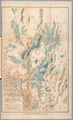
Russell, Israel C. (Israel Cook), 1852-1906.
Full Title
Lake Lahontan : a quaternary lake of northwestern Nevad, by Israel C. Russell. Assisted by A.L. Webster, W.D. Johnson, cartographers ; W.J. McGee. GEO. M. Wright, geologists. Mountain shading, by W.J. Hays. Topography compiled by Eugene Rickseker ... (to accompany) Geological history of Lake Lahontan : a quaternary lake of Northwestern Nevada. (series title) Department of Interior : Monographs of the United States Geological Survey, vol. XI. (on upper margin) U.S. Geological Survey; Lake Lahontan PL. XLVI.
Publisher
U.S. Govt. Print Office
Author
Hubbard, William
Full Title
A map of New England, being the first that ever was here cut, and done by the best pattern that could be had, which being in some places defective, it made the other less exact: Yet doth it sufficiently show the situation of the country and conveniently well the distance of Places. The figures that are joyned with the Names of Places are to distinguish such as have been assaulted by the Indians from others. (to accompany) A Narrative of the Troubles with the Indians in New-England, from ... 1607 to this present year 1677. (with) The Happiness of a People in the Wisdome of their Rulers Directing and in Obedience of their Brethren Attending unto what Israel ought to do: Recommended in a Sermon ... Boston, Printed by John Foster. 1676.
Publisher
John Foster
Author
Whitney, Asa
Full Title
No. 1 (World map on a Mercator Projection). "This map shews the position of our continent as compared with Europe and Africa on one side and Asia on the other, placing US in the centre". This map was prepared by Mr. Whitney for Mr. Breese's report to the Senate, U.S. 29 Congrees. Miller's Lith. 102 Broadway, N.Y. (on the lower margin) 1235. (to accompany) A Project For A Railroad To The Pacific. By Asa Whitney, of New York.
Publisher
George W. Wood
Author
Whitney, Asa
Full Title
No. 2 ( A map of North America showing possible rail routes across the continent.) Miller's Lith. 102 Broadway, N.Y. "N.B. this map shews very nealy the sphere of the Globe, and the line from Baltimore and the line from Panama to Puget Sound, would be the air line route. (to accompany) A Project For A Railroad To The Pacific. By Asa Whitney, of New York.
Publisher
George W. Wood
Author
Davis, Charles Henry
Full Title
No.I. General map of the American Isthmuses showing the various lines proposed for Interoceanic communication, compiled by Rear Admiral C.H. Davis, U.S.N. Superintendent U.S. Naval Observatory, Washington D.C. "To accompany Report ordered by resolution of the Senate of the United States of March 19th. 1866". Drawn by Louis Waldecker, Washington. Bowen & Co. Lith. Philada.
Publisher
[Bowen & Co., U.S.]
Author
Davis, Charles Henry
Full Title
No.II. Profiles of the Isthmus of Tehnantepec : taken from surveys made under the direction of J.G. Barnard, Col. U.S. Engrs., 1851. Profile of the route from Minatitlan to La Ventosa ... Profile of the line between the Atlantic plains (Jaltepec River) and the Pacific Plains (Rancho de la Mata). Bowen & Co. Lith. Philada. "To accompany Report of Rear Admiral C.H. Davis, U.S.N., ordered by resolution of the Senate of the United States of March 19th. 1866".
Publisher
[Bowen & Co., U.S.]
Author
Davis, Charles Henry
Full Title
No.III. Map of vertical section of the proposed Honduras interoceanic railway. Located 1857 & 1858. Authorities. E.G. Squier ... J.C. Trautwine ... Com. W.N. Jefers, U.S.N. Hydrographic Eng. & Deputy Agt. Drawn by G. Thompson, June, 1866. Bowen & Co. Lith. Philada. "To accompany Report of Rear Admiral C.H. Davis, U.S.N., ordered by resolution of the Senate of the United States of March 19th. 1866". (inset) Profile.
Publisher
[Bowen & Co., U.S.]
Author
[Davis, Charles Henry, American Atlantic and Pacific Ship Canal Company]
Full Title
No.IV. Map and profile of the route from construction of a ship canal from the Atlantic to the Pacific oceans. Across the Isthmus in the State of Nicaragua, Central America. Surveyed for American Atlantic & Pacific Ship Canal Company, by O.W. Childs. 1850-51. Bowen & Co. Lith. Philada. "To accompany Report of Rear Admiral C.H. Davis, U.S.N., ordered by resolution of the Senate of the United States of March 19th. 1866".
Publisher
[Bowen & Co., U.S.]
Author
Davis, Charles Henry
Full Title
No.V. Map of the Isthmus between Chagres and Panama. By Chief Engineer Napoleon Garella, 1845 : (Panama Rail Road added.) Drawn by E. Hergesheimer. June 1866. Bowen & Co. Lith. Philada. "To accompany Report of Rear Admiral C.H. Davis, U.S.N., ordered by resolution of the Senate of the United States of March 19th. 1866". (inset) Profile of proposed canal.
Publisher
[Bowen & Co., U.S.]
Author
Davis, Charles Henry
Full Title
No.VI. Panama rail road : Central America ; surveyed by Coll. G.W. Hughes, Engineer. 1849.Bowen & Co. Lith. Philada. "To accompany Report of Rear Admiral C.H. Davis, U.S.N., ordered by resolution of the Senate of the United States of March 19th. 1866". (inset profile) Section along the rail road.
Publisher
[Bowen & Co., U.S.]
Author
[Davis, Charles Henry, McDouglas, A.]
Full Title
No.VII. Map and profile of the route for the construction of a ship canal between the Pacific and Atlantic Oceans. A.McDouglas ... C.A. Sweet ... J.E. Forman ... N. Rude. 1864. Surveyed by order of Frederick M. Kelley, Cyrus Butler, Luker T. Merrill. Bowen & Co. Lith. Philada. "To accompany Report of Rear Admiral C.H. Davis, U.S.N., ordered by resolution of the Senate of the United States of March 19th. 1866". (profile) Cordilleras, (insets) Cross section of canal near tunnel, and Cross section beyond river at tidal lock.
Publisher
U.S.
Author
Davis, Charles Henry
Full Title
No.VIII. Isthmus of Darien. Map showing the route of commander Prevost, from Rancho No. 1 on the Savana River, to Rancho No.12, beyond Prevost River, to which are added the survey and sections of the Isthmus. By Lionel Gisborne, Esqr. C.E. 1854. Bowen & Co. Lith. Philada. "To accompany Report of Rear Admiral C.H.Davis, U.S.N., ordered by resolution of the Senate of the United States of March 19th. 1866". (with 2 profiles).
Publisher
U.S.
Author
[Davis, Charles Henry, Cullen, Dr.]
Full Title
No.IX. Map of part of the Isthmus of Darien; by Dr. Cullen. Bowen & Co. Lith. Philada. "To accompany Report of Rear Admiral C.H.Davis, U.S.N., ordered by resolution of the Senate of the United States of March 19th. 1866". (inset) Bird's eye view from the junction of the proposed canal with the Savana River to the Atlantic ; by Dr. Cullen.
Publisher
[N.P., Bowen & Co.]
Author
[Davis, Charles Henry, Cullen, Dr.]
Full Title
No.X. Map of an exploration for an inter-oceanic canal by way of the Rivers Atrato and San Juan in New Granada, S.A. : laid down from observations made by John C. Trautwine, c.e., in 1852.. Bowen & Co. Lith. Philada. "To accompany Report of Rear Admiral C.H.Davis, U.S.N., ordered by resolution of the Senate of the United States of March 19th. 1866". (inset profile) Route of the line of the levels.
Publisher
[N.P., Bowen & Co.]
Author
[Davis, Charles Henry, Cullen, Dr.]
Full Title
No.XI. General sketch of the survey for an interoceanic ship canal near the Isthmus of Darien via the Rivers Atrato and Truando : made in accordance with the Act of Congress of March 3rd, 1857, under the direction of the Hon. Secretaries of War and of the Navy by Lieut. N. Michler, Top. Eng. U.S.A. ; assisted by Messrs. A.C.V. Schott, J. de la Camp, J. Schmitt, L. Daser, W.H.W. Campbell, and P. Henrick. 1858 &59. Bowen & Co. Lith. Philada. "To accompany Report of Rear Admiral C.H.Davis, U.S.N., ordered by resolution of the Senate of the United States of March 19th. 1866".
Publisher
[Bowen & Co., N.P.]
Author
[Davis, Charles Henry, Cullen, Dr.]
Full Title
No.XII. Interoceanic ship canal via Atrato and Truando Rivers. Michler. Profile along the surveyed route. Profile along along the proposed ship canal route. Bowen & Co. Lith. Philada. "To accompany Report of Rear Admiral C.H.Davis, U.S.N., ordered by resolution of the Senate of the United States of March 19th. 1866".
Publisher
[Bowen & Co., N.P.]
|