Browse All

1760 Canada, N. pt. Louisiana. Geography Book A map of Canada and the north part of Lo … |

1759 City of Quebec. Geography Book A plan of the city of Quebec, the capita … |

1758 Montreal or Ville Marie. Geography Book Plan of the town and fortifications of M … |

1755 Nova Scotia, Cape Britain. Geography Book A new map of Nova Scotia and Cape Britai … |

1758 Louisburg. Geography Book A plan of the city and fortifications of … |

1759 River St. Laurence. Geography Book An authentic plan of the River St. Laure … |

1755 North America. Geography Book North America from the French of Mr. d'A … |

1759 New Orleans. Geography Book Plan of New Orleans the capital of Louis … |

1760 West Indies. Geography Book The West Indies exhibiting the English, … |

1760 Hispaniola, St. Domingo. Geography Book The island of Hispaniola called by the F … |

1760 Cap Francois. Geography Book An authentic plan of the town and harbou … |

1760 Guadaloupe. Geography Book Guadaloupe, one of the Caribbee islands … |

1760 Basse Terre. Geography Book Plan of the town of Basse Terre, the cap … |

1760 Martinico. Geography Book Martinico, one of the Caribbee Islands, … |

1760 Fort Royal, Martinico. Geography Book Plan of the town and citadel of Fort Roy … |

1760 Grenada. Geography Book Plan of the town and fort of Grenada, by … |

1760 Cayenne. Geography Book The island and colony of Cayenne subject … |

1760 Cayenne, Ft. St. Michael. Geography Book Plan of the town of Cayenne and Fort St. … |

1904 San Francisco. [Guide Book, Pocket Map] The commercial, pictorial and tourist ma … |

1864 Geological map and profiles of some of t … Exploration Book Geological map and profiles of some of t … |
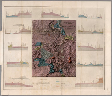
1864 Geological map and profiles of some of t … Exploration Book Geological map and profiles of some of t … |

1852 Map of the Great Salt Lake. Exploration Book Map of the Great Salt Lake And Adjacent … |

1852 Map of a Reconnoissance between Fort Lea … Exploration Book Map of a Reconnoissance between Fort Lea … |

1804 Carte de la Republique Francaise Apres l … Geography Book Carte de la Republique Francaise Apres l … |

1804 Carte physique de la navigation interieu … Geography Book Carte physique de la navigation interieu … |

1803 Carte des iles Antilles. Par J.B. Poirso … Geography Book Carte des iles Antilles. Par J.B. Poirso … |

1803 Carte de St. Domingue Geography Book Carte de St. Domingue ... Par J.B. Poirs … |

1803 Carte de St. Domingue Geography Book Carte de la Guiane Francaise et Hollanda … |

1803 Carte d'Afrique Geography Book Carte d'Afrique ; Par J.B. Poirson, inge … |

1804 Carte de la cote occidentale de l'Afriqu … Geography Book Carte de la cote occidentale de l'Afriqu … |

1803 Carte de la Inde Geography Book Carte de la Inde, par J. B. Poirson, ing … |
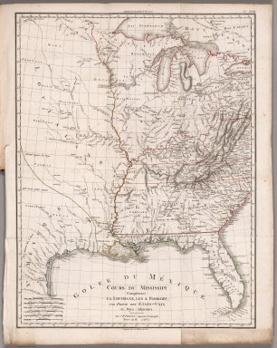
1803 Cours du Mississippi comprenant la Louis … Geography Book Cours du Mississippi comprenant la Louis … |

1856 A New Map For Travellers Through the Uni … Guide Book A New Map For Travellers Through the Uni … |

1846 Map of Mexico including Yucatan Guide Book Map of Mexico including Yucatan. Entered … |

1898 Text Page: Yellowstone National Park. Timetable Map (Text Page to) The Yellowstone National … |

1842 Chart Of The World Shewing The Tracks of … Exploration Book Chart Of The World Shewing The Tracks of … |

1840 Chart of the Antarctic Continent. Exploration Book Chart of the Antarctic Continent Shewing … |

1840 Chart of the Viti Group or Feejee Island … Exploration Book Chart of the Viti Group or Feejee Island … |

1841 Map of the Oregon Territory. Exploration Book Map of the Oregon Territory by the U.S. … |

1841 Map of Part of the Island of Hawaii, San … Exploration Book Map of Part of the Island of Hawaii, San … |

1777 S. extremity of America. Exploration Book A chart of the southern extremity of Ame … |

1777 S. Atlantic discoveries. Exploration Book Chart of the discoveries made in the Sou … |

1785 Kerguelen's Land. Exploration Book Kerguelen's Land called by C. Cook Islan … |

1785 Port Palliser, Christmas Harbour. Exploration Book Sketch of Port Palliser on Kerguelen's-L … |

1785 Van Diemen's Land. Exploration Book Chart of Van Diemen's Land. Harmar scrip … |

1785 Adventure Bay, Van Diemens Land. Exploration Book Plan of Adventure Bay in Van Diemens Lan … |

1785 Friendly Islands chart. Exploration Book Chart of the Friendly Islands. Writing b … |

1785 Tongataboo Harbour. Exploration Book Sketch of Tongataboo Harbour, 1777. The … |

1785 (Wanooaette, Wateeoo, Mangeea, Toobouai … Exploration Book (Plans of islands in the South Pacific. … |

1785 Eimeo harbours. Exploration Book Sketch of the harbours on the north side … |