WHERE
-
Abington (Md.)
(1)
-
Adventure Bay Region (Tas
…
(1)
-
Africa
(3)
-
Africa, West
(1)
-
Alabama
(1)
-
Alaska
(10)
-
Albany (N.Y.)
(1)
-
Albany County (N.Y.)
(1)
-
Alberta
(1)
-
Allentown (N.J.)
(1)
-
American Samoa
(1)
-
Annapolis (Md.)
(1)
-
Antarctica
(1)
-
Argentina
(2)
-
Arizona
(20)
-
Arkansas
(1)
-
Asia
(1)
-
Atlantic
(1)
-
Atlantic Ocean
(2)
-
Atrato River Region (Colo
…
(2)
-
Australia
(7)
-
Avacha Bay (Russia)
(1)
-
Baffin Bay (North Atlanti
…
(1)
-
Bahamas
(1)
-
Baltimore
(1)
-
Baltimore (Md.)
(9)
-
Bantaeng Region (Indonesi
…
(1)
-
Basse-Terre (Guadeloupe)
(1)
-
Bergen (N.J.)
(1)
-
Bering Sea
(1)
-
Bermuda
(1)
-
Black Hills (S.D. and Wyo
…
(3)
-
Black Horse (N.J.)
(1)
-
Bonumtown (N.J.)
(1)
-
Boston
(2)
-
Boston (Mass.)
(5)
-
Botany Bay (N.S.W.)
(1)
-
Bowling-green Ord. (Va.)
(1)
-
Brandywine
(1)
-
Bristol (N.J.)
(1)
-
Bristol (Pa.)
(1)
-
British Columbia
(7)
-
Brooklyn
(1)
-
Brunswick (N.J.)
(1)
-
California
(47)
-
California, Northern
(1)
-
Canada
(20)
-
Cap-Haitien (Haiti)
(1)
-
Cap-Haitien Region (Haiti
…
(1)
-
Cape Breton Island
(1)
-
Cape Verde
(1)
-
Caribbean Area
(2)
-
Cates (N.Y.)
(1)
-
Cattail (N.J.)
(1)
-
Cayenne (French Guiana)
(1)
-
Central America
(13)
-
Central Valley
(1)
-
Charlestown (Md.)
(2)
-
Chesapeake and Delaware C
…
(1)
-
Chester
(2)
-
Chile
(7)
-
China
(1)
-
Christmas Sound (Chile)
(1)
-
Chukchi Sea
(1)
-
Claverack (N.Y.)
(1)
-
Colne Valley (England)
(5)
-
Colombia
(3)
-
Colorado
(5)
-
Columbia County (N.Y.)
(1)
-
Connecticut
(12)
-
Cook Inlet Region (Alaska
…
(1)
-
Cook Islands
(1)
-
Cook Strait (N.Z.)
(1)
-
Cordes Bay (Chile)
(1)
-
Coromandel Peninsula (N.Z
…
(1)
-
Cranberry (N.J.)
(1)
-
Crosswicks (N.J.)
(1)
-
Cuba
(1)
-
Danbury (Conn.)
(1)
-
Darby (Pa.)
(1)
-
Delaware
(9)
-
Denver
(1)
-
District of Columbia
(3)
-
Dobbs Ferry (N.Y.)
(1)
-
Dominican Republic
(2)
-
Dumond (N.Y.)
(1)
-
Dusky Sound (N.Z.)
(1)
-
Dutchess County (N.Y.)
(1)
-
Easter Island
(1)
-
Elizabeth (N.J.)
(1)
-
Elizabethtown (N.J.)
(1)
-
Elk Ridge (Md.)
(1)
-
Elk Town
(1)
-
Endeavour River (Qld.)
(1)
-
England
(3)
-
English Bay (Alaska)
(1)
-
Erie Canal (N.Y.)
(1)
-
Europe
(1)
-
Fairfield (Conn.)
(1)
-
Falkland Islands
(1)
-
Falmouth (Va.)
(1)
-
Fiji
(1)
-
Fiji Islands
(1)
-
Filkin (N.Y.)
(1)
-
Fishkill (N.Y.)
(1)
-
Florida
(6)
-
Fort Washington (N.Y.)
(1)
-
Fort-de-France (Martiniqu
…
(1)
-
France
(2)
-
Frankford (N.J.)
(1)
-
Frankford (Pa.)
(1)
-
Fredericksburg (Va.)
(1)
-
French Guiana
(3)
-
Gabarus Bay (N.S.)
(1)
-
Gallant, Port (Chile)
(1)
-
Georgia
(4)
-
Golden Gate Park
(1)
-
Grand Canyon (Ariz.)
(2)
-
Great Salt Lake
(5)
-
Grenada
(1)
-
Guadeloupe
(1)
-
Guiana
(1)
-
Haiti
(3)
-
Haleakala (Hawaii)
(1)
-
Hanover (Va.)
(1)
-
Hanover Court House (Va.)
(1)
-
Hartford (Md.)
(1)
-
Hawaii
(6)
-
Head Lynch (Va.)
(1)
-
Head of Elk (Md.)
(1)
-
Hershey
(1)
-
Holbroke (N.Y.)
(1)
-
Honduras
(1)
-
Hudson Bay
(1)
-
Hudson River
(4)
-
Idaho
(3)
-
Illinois
(6)
-
India
(1)
-
Indian Territory
(2)
-
Indiana
(4)
-
Indonesia
(3)
-
Iowa
(4)
-
Island Bay (Chile)
(1)
-
Islands, Bay of (N.Z.)
(1)
-
Jamaica
(1)
-
Joppa (Md.)
(1)
-
Kansas
(5)
-
Kealakekua Bay (Hawaii)
(1)
-
Kenderhook (N.Y.)
(1)
-
Kentucky
(9)
-
Kerguelen Islands
(2)
-
Kilauea Volcano (Hawaii)
(1)
-
Kings Bridge (N.Y.)
(1)
-
Kingsbury Ironworks (Md.)
(1)
-
Kingston (N.J.)
(1)
-
Kingston (N.Y.)
(1)
-
Kiribati
(1)
-
Kiritimati Island (Kiriba
…
(1)
-
Kooksachke (N.Y.)
(1)
-
Lake County (Calif.)
(1)
-
Land of Standing Rocks (U
…
(1)
-
Los Angeles County (Calif
…
(1)
-
Louisbourg (N.S.)
(1)
-
Louisbourg Region (N.S.)
(1)
-
Louisiana
(7)
-
Louisville (Ky.)
(3)
-
Macau (China : Special Ad
…
(1)
-
Maidenhead (N.J.)
(1)
-
Maine
(3)
-
Manhattan (New York, N.Y.
…
(1)
-
Manitoba
(1)
-
Manuae (Cook Islands)
(1)
-
Mapia Island (Indonesia)
(1)
-
Marin County (Calif.)
(1)
-
Maritime Provinces
(2)
-
Marquesas Islands (French
…
(1)
-
Martinique
(2)
-
Maryland
(24)
-
Massachusetts
(13)
-
Matavai Bay (Tahiti)
(1)
-
Mauna Loa (Hawaii Island,
…
(1)
-
Mexico
(16)
-
Michigan
(3)
-
Middlesex (Conn.)
(1)
-
Miller (N.Y.)
(1)
-
Mindanao Island (Philippi
…
(1)
-
Minnesota
(7)
-
Mississippi
(1)
-
Mississippi River
(3)
-
Mississippi River Delta (
…
(1)
-
Missouri
(5)
-
Missouri River
(1)
-
Montana
(8)
-
Monterey (Calif.)
(1)
-
Monterey Bay (Calif.)
(1)
-
Monterey County (Calif.)
(1)
-
Montreal (Quebec)
(1)
-
Moorea (Society Islands)
(2)
-
Moorstown (N.J.)
(1)
-
Mount Holly (N.J.)
(1)
-
Nebraska
(7)
-
Nevada
(27)
-
New Britain Island (Papua
…
(1)
-
New Brunswick
(4)
-
New Brunswick (N.J.)
(1)
-
New Caledonia
(1)
-
New Castle (Va.)
(1)
-
New England
(2)
-
New Georgia Group (Solomo
…
(1)
-
New Guinea
(1)
-
New Hampshire
(4)
-
New Jersey
(22)
-
New Mexico
(8)
-
New Orleans (La.)
(4)
-
New Rochelle (N.Y.)
(1)
-
New South Wales
(1)
-
New York
(62)
-
New York (N.Y.)
(15)
-
New York City
(3)
-
New Zealand
(4)
-
Newark (N.J.)
(2)
-
Newborough (N.Y.)
(1)
-
Newfoundland
(2)
-
Newport
(1)
-
Newtown (Conn.)
(1)
-
Niagara Falls (N.Y. and O
…
(1)
-
Nicaragua
(2)
-
Niuatoputapu (Tonga)
(1)
-
Niue
(1)
-
Nootka Sound (B.C.)
(1)
-
Norfolk Island
(1)
-
North America
(20)
-
North Carolina
(6)
-
North Dakota
(4)
-
Northern Hemisphere
(2)
-
Norwalk (Conn.)
(1)
-
Nottingham Ironworks (Md.
…
(1)
-
Nova Scotia
(4)
-
Ohio
(5)
-
Ohio River
(3)
-
Oklahoma
(2)
-
Ontario
(2)
-
Oregon
(10)
-
Pacific
(4)
-
Palmerston Atoll (Cook Is
…
(1)
-
Panama
(8)
-
Papua New Guinea
(1)
-
Patagonia (Argentina and
…
(1)
-
Peekskill (N.Y.)
(1)
-
Peekskill Lands (N.Y.)
(1)
-
Pennsylvania
(21)
-
Philadelphia (Pa.)
(12)
-
Philippines
(1)
-
Pickersgill Harbour (N.Z.
…
(1)
-
Piscataway (N.J.)
(1)
-
Pittsburgh (Pa.)
(1)
-
Platte River
(1)
-
Poughkeepsie (N.Y.)
(1)
-
Prince Edward Island
(2)
-
Prince William Sound Regi
…
(1)
-
Princeton (N.J.)
(1)
-
Providencia, Cape (Chile)
(1)
-
Putnam County (N.Y.)
(1)
-
Pyramid Lake (Nev.)
(2)
-
Quebec
(6)
-
Quebec (Quebec)
(1)
-
Quebec Region (Quebec)
(1)
-
Queensland
(2)
-
Red Hook (N.Y.)
(1)
-
Rensselaer County (N.Y.)
(1)
-
Resolution, Port (Vanuatu
…
(1)
-
Rhode Island
(4)
-
Rio Del Norte
(1)
-
Rio Gila
(1)
-
Robertson
(1)
-
Rocky Mountains
(1)
-
Rogers (N.Y.)
(1)
-
Russia
(2)
-
Rye (N.Y.)
(1)
-
Rynbeck Flats (N.Y.)
(1)
-
Sacramento County (Calif.
…
(1)
-
Saint George's (Grenada)
(1)
-
Saint Lawrence River
(1)
-
Saint Louis (Mo.)
(1)
-
Saint Paul (Minn.)
(1)
-
Samoan Islands
(1)
-
San Diego (Calif.)
(1)
-
San Diego County (Calif.)
(1)
-
San Francisco
(2)
-
San Francisco (Calif.)
(8)
-
San Francisco Bay
(1)
-
San Francisco Bay Area (C
…
(1)
-
San Joaquin County (Calif
…
(1)
-
San Luis Obispo (Calif.)
(1)
-
San Mateo County (Calif.)
(1)
-
Sandwich, Port (Vanuatu)
(1)
-
Santa Clara County (Calif
…
(1)
-
Santa Cruz (Calif.)
(1)
-
Santa Cruz Islands (Solom
…
(1)
-
Saratoga County (N.Y.)
(1)
-
Saratoga Springs (N.Y.)
(1)
-
Saskatchewan
(1)
-
Slabtown (N.J.)
(1)
-
Society Islands (French P
…
(3)
-
Solano County (Calif.)
(1)
-
Solomon Islands
(1)
-
Sonoma County (Calif.)
(1)
-
South America
(4)
-
South Bay
(1)
-
South Carolina
(4)
-
South Dakota
(9)
-
South Georgia and South S
…
(1)
-
Southern California
(1)
-
Southern Hemisphere
(1)
-
Staatsborough (N.Y.)
(1)
-
Stanford (Conn.)
(1)
-
Stanislaus County (Calif.
…
(1)
-
Steenbergh (N.Y.)
(1)
-
Stratford (Conn.)
(2)
-
Striker (N.J.)
(1)
-
Sulu Archipelago (Philipp
…
(1)
-
Sulu Sea
(1)
-
Superior, Lake
(1)
-
Surinam
(1)
-
Susquehannah River (Md.)
(1)
-
Tafahi (Tonga)
(1)
-
Tahiti
(2)
-
Tarrytown (N.Y.)
(1)
-
Tasmania
(2)
-
Tehuantepec, Isthmus of (
…
(4)
-
Tennessee
(4)
-
Texas
(6)
-
Thorntown (Va.)
(1)
-
Tierra del Fuego (Argenti
…
(2)
-
Tonga
(4)
-
Tongatapu Island (Tonga)
(1)
-
Treasure Island
(2)
-
Trenton (N.J.)
(2)
-
Tuamotu Islands
(1)
-
U.S. Mid West
(22)
-
U.S. North East
(9)
-
U.S. North West
(2)
-
U.S. South
(4)
-
U.S. South West
(3)
-
U.S. Southwest
(1)
-
U.S. West
(31)
-
United States
(92)
-
Utah
(13)
-
Vancouver Island
(1)
-
Vanuatu
(2)
-
Vatoa Island (Fiji)
(1)
-
Vermont
(3)
-
Virginia
(12)
-
Wales
(2)
-
Wallis Islands (Wallis an
…
(1)
-
Wappinskill (N.Y.)
(1)
-
Washington
(6)
-
Washington (D.C.)
(2)
-
West Indies
(3)
-
West Virginia
(1)
-
Westchester County (N.Y.)
(1)
-
Western Samoa
(1)
-
Western Territory
(1)
-
White Mountains (N.H.)
(2)
-
Wilmington
(1)
-
Wilmington (Del.)
(1)
-
Wisconsin
(5)
-
World
(8)
-
Wyoming
(8)
-
Yellowstone National Park
(2)
-
Yellowstone River
(1)
-
Yorkshire (England)
(5)
-
Zanesville (Ohio)
(1)
-
Zurich (Switzerland)
(1)
Show Less
|
Full Title
Map of Oregon, California, New Mexico, N.W. Texas & the proposed Territory of Ne-Bras-Ka. By Rufus B. Sage. 1846. F. Michelin's Lith. 111 Nassau St. N.Y.
Full Title
Map of the United States of America. J. Melish del. H.S. Tanner Sc.
Publisher
Palmer, Thomas & George
Full Title
Chart of the Atlantic Ocean.
Publisher
Palmer, Thomas & George
Full Title
View of the Country round Pittsburg. Drawn by J. Melish. J. Vallance F.S.A. sculpt.
Publisher
Palmer, Thomas & George
Full Title
Falls of Ohio.
Publisher
Palmer, Thomas & George
Full Title
Kentucky. Drawn by J. Melish. J. Vallance sc.
Publisher
Palmer, Thomas & George
Full Title
Ohio. Drawn by J. Melish. J. Vallance sc.
Publisher
Palmer, Thomas & George
Full Title
View of the Country round Zanesville. Drawn by J. Melish. J. Vallance F.S.A. sculpt.
Publisher
Palmer, Thomas & George
Full Title
View of the Country round the Falls of Niagara. Drawn by J. Melish. J. Vallance F.S.A. Sculpt.
Publisher
Palmer, Thomas & George
Author
Gregg, Josiah, 1806-1850
Full Title
A Map of the Indian Territory Northern Texas and New Mexico Showing the Great Western Prairies by Josiah Gregg. Entered ... 1844 by Sidney E. Morse and Samuel Breese ... New York.
Publisher
[Henry G. Langley, Wiley and Putnam.]
Author
Gregg, Josiah, 1806-1850
Full Title
Map of the Interior of Northern Mexico.
Publisher
[Henry G. Langley, Wiley and Putnam.]
Author
[Birkbeck, Morris, Melish, John]
Full Title
United States. Published 1st June 1816 by J. Melish. Philadelphia. Improved to 1818.
Author
[Birkbeck, Morris, Melish, John]
Full Title
English Prairie and Adjacent Country. T.V.K & Co. Sc. J. Melish Del.
Full Title
A Map of the United States of America. By Samuel G. Lewis.
Full Title
A Map of The Western Part of the Territories belonging to the United States of America. Drawn from the best Authorities. Engraved for Imlay's Topographical Description of that Country. T. Conder Sculpt. Published June 1st 1795, by J. Debrett, Picadilly, London.
Full Title
A Plan of the Rapids of the Ohio. T. Conder, Sculpt. Engraved for Imlay's American Topography. Published Feby. 1st, 1793, by J. Debrett, Piccadilly, London.
Full Title
A Map of the State of Kentucky, from Actual Survey by Elihu Barker of Philadelphia. T. Conder Sculpt. London, Published June 1st, 1795 by J. Debrett, PIccadilly.
Full Title
A Map of the Tennassee Government, formerly part of North Carolina, taken chiefly from Surveys by Genel. D. Smith & others. T. Conder Sculpt. Engraved for Imlay's American Topography. London, Published June 1st, 1795, by J. Debrett, Piccadilly.
Full Title
A Map of the States of Virginia, North Carolina, South Carolina and Georgia Comprehending the Spanish Provinces of East and West Florida Exhibiting the boundaries as fixed by the late Treaty of Peace between the United States and the Spanish Dominions. Compiled from late Surveys and Observations by Joseph Purcell. Engraved for Morse's Geography by Amos Doolittle at New Haven, 1788.
Publisher
Shepard Kollock
Full Title
A Map of the Northern and Middle States; Comprehending the Western Territory and the British Dominions in North America. Compiled from the best Authorities. Delineated & Engrav'd for Morse's Geography by Amos Doolittle, New Haven.
Publisher
Shepard Kollock
Full Title
Die Vereinigten Staaten von Nord-America. Entworfen von J.E. Woerl. Lithographie von B. Herder in Freiburg im Breisgau.
Full Title
Map of the Indian Tribes of North America about 1600 A.D. along the Atlantic; & about 1800 A.D. westwardly. Published by the Amer: Antiq: Soc: From a drawing by Hon: A. Gallatin.
Publisher
The University Press
Author
[Allen, Paul, Biddle, Nicholas, Clark, William, Lewis, Meriwether]
Full Title
A Map of Lewis and Clark's Track, Across the Western Portion of North America From the Mississippi to the Pacific Ocean; By Order of the Executive of the United States, in 1804, 5 & 6. Copied by Samuel Lewis from the Original Drawing of Wm. Clark. Smal. Harrison fct.
Publisher
Bradford and Inskeep
Author
[Allen, Paul, Biddle, Nicholas, Clark, William, Lewis, Meriwether]
Full Title
Fortification.
Publisher
Bradford and Inskeep
Author
[Allen, Paul, Biddle, Nicholas, Clark, William, Lewis, Meriwether]
Full Title
The Falls and Portage.
Publisher
Bradford and Inskeep
Author
[Allen, Paul, Biddle, Nicholas, Clark, William, Lewis, Meriwether]
Full Title
Great Falls of Columbia River.
Publisher
Bradford and Inskeep
Author
[Allen, Paul, Biddle, Nicholas, Clark, William, Lewis, Meriwether]
Full Title
The Great Shoot or Rapid.
Publisher
Bradford and Inskeep
Author
[Allen, Paul, Biddle, Nicholas, Clark, William, Lewis, Meriwether]
Full Title
Mouth of Columbia River.
Publisher
Bradford and Inskeep
Full Title
Map of the United States of America. J. Melish del. Designed to illustrate the Geological Memoir of Wm. Maclure Esqr. Transactions American Philosophical Society, Vol. I. New Series. Entered ... and Published by John Melish, Philadelphia.
Author
[Abel, Henry J., Young, James H.]
Full Title
Map of the Settled Part of Wisconsin Territory compiled from the Latest Authorities by Aug. Mitchell. Philadelphia. Improved and Published by Henry J. Abel, of Wis. Ter. Compiled and Engraved by J.H. Young, Philada. 1838. (with) The Entire Territory of Wisconsin. As Established by Act of Congress. April 10, 1836.
Full Title
United States of North America.
Author
[Churchman, Joseph and James, Moore, I.W.]
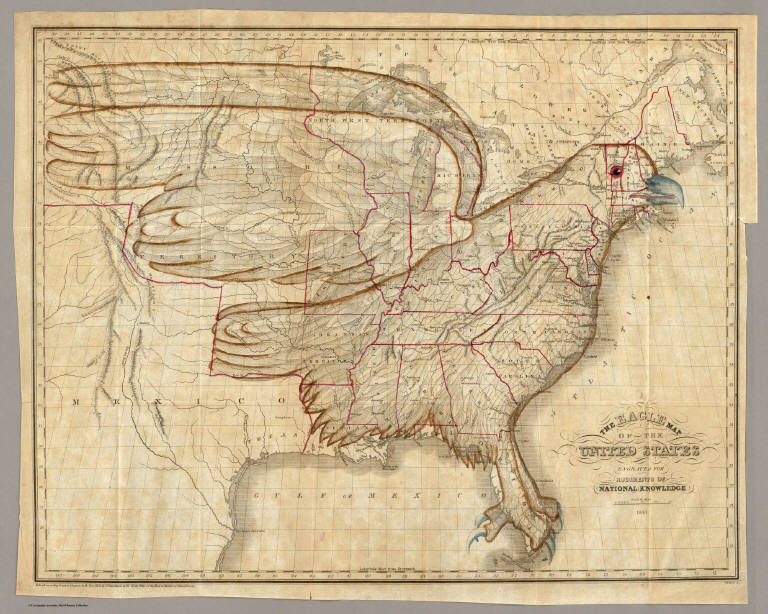
Full Title
The Eagle Map of the United States Engraved for Rudiments of National Knowledge. 1833.
Publisher
E.L. Carey & A. Hart
Author
U.S. Department of the Interior
Full Title
Topographical Map Of The Yosemite Valley And Vicinity. Part Of East Central California. Mountain Drawing by J.E. Weyss; Lettering by J. Franke. From Topographical Plat by Lt. Macomb, Nov. 30, 1883. The Norris Peters Co. Photo-Litho., Washington, D.C. Expeditions Of 1878-79, Under the Command of Capt. Geo. M. Wheeler, Corps of Engineers, U.S. Army. U.S. Geographical Surveys West Of The 100th Meridian. (Printed in red above border) Yosemite State Park, showing toll roads leading into.
|