Who What Where WhenREMOVEWHO
|
Author
Blum, George W.
Full Title
Map of the Golden Gate Park, the Avenue and Buena Vista Park. 1895.
Publisher
Geo. W. Blum
Author
Blum, George W.
Full Title
Untitled map of Sonoma, Marin, Lake, and Napa Counties.
Publisher
Geo. W. Blum
Author
Blum, George W.
Full Title
(Untitled map of the South Bay including San Mateo, Santa Cruz, Santa Clara, Alameda, and Contra Costa Counties.)
Publisher
Geo. W. Blum
Author
Blum, George W.
Full Title
(Untitled map of the area around Sacramento and Marysville including Colusa, Yolo, Napa, Butte, Yuba, Sutter, Solano, and Sacramento Counties.)
Publisher
Geo. W. Blum
Author
Blum, George W.
Full Title
(Untitled map of the Central Coast area including San Benito, Fresno, Monterey, San Luis Obispo, Kings, Kern, and Santa Barbara Counties.)
Publisher
Geo. W. Blum
Author
Blum, George W.
Full Title
(Untitled map of the Central Valley area including Sacramento, Amador, Calaveras, San Joaquin, Tuolumne, Stanislaus, Merced, and Mariposa Counties.)
Publisher
Geo. W. Blum
Author
Blum, George W.
Full Title
(Untitled map of Southern California including Ventura, Los Angeles, San Bernardino, Orange, and San Diego Counties.)
Publisher
Geo. W. Blum
Author
Blum, George W.
Full Title
Map of California Roads for Cyclers. This Map Engraved by the California Photo-Eng. Co. Wasp B'ld'g., 513 Market St., S.F. Designed & Drawn by Geo. W. Blum. Edward Denny & Co. 207 Montgomery St. Sole Agents. Published and Copyrighted by Geo. W. Blum, San Francisco, Cal. (with) Inset map of the Los Angeles area.
Publisher
Geo. W. Blum
Author
Morse, Jedidiah
Full Title
A Map of the State of New York. J. Roper, sc. Published Augt. 20th 1794 by J. Stockdale, Piccadilly.
Publisher
John Stockdale
Author
Morse, Jedidiah
Full Title
A Map of New Jersey from the best Authorities. Published Sepr. 8th 1794 by J. Stockdale, Piccadilly.
Publisher
John Stockdale
Author
Morse, Jedidiah
Full Title
A Map of Pensylvania from the best Authorities. W. Harrison Junr. sc. Published 15th July 1794 by J. Stockdale, Piccadilly.
Publisher
John Stockdale
Author
Morse, Jedidiah
Full Title
A Map of the States of Virginia, North Carolina, South Carolina, and Georgia; Comprehending the Spanish Provinces of East and West Florida: Exhibiting the Boundaries as fixed by the late Treaty of Peace between the United States and the Spanish Dominions. Compiled from late Surveys & Observations by Joseph Purcell. W. Harrison Senr. & Junr. sc. Engraved for Morse's Geography. Publish'd by John Stockdale Jany. 25th 1792.
Publisher
John Stockdale
Author
Morse, Jedidiah
Full Title
Plan of the City of Washington. Published by J. Stockdale, PIccadilly 16th Septr. 1794.
Publisher
John Stockdale
Author
Morse, Jedidiah
Full Title
Map of Virginia, Maryland and Delaware. I. Mulow Sc. 6 James St. Covt. Gardn. Published July 16, 1794 by I. Stockdale, PIccadilly.
Publisher
John Stockdale
Author
Morse, Jedidiah
Full Title
A Map of the Back Settlements. Published, July 30, 1794 by I. Stockdale, Piccadilly.
Publisher
John Stockdale
Author
Emory, William H.
Full Title
Military Reconnaissance Of The Arkansas Rio Del Norte And Rio Gila By W.H. Emory, Lieut. Top. Engrs. Assisted ... by J.W. Abert and W.G. Peck, and ... by W.H. Warner and Mr. Norman Bestor, Made in 1846-7, with the advance guard of the "Army of the West". Under Command Of Brig. Gen. Stephn. W. Kearny. Constructed under the orders of Col. J.J. Abert ... 1847. Drawn by Joseph Welch. Engraved on stone by E. Weber & Co. Baltimore.
Publisher
Wendell and Van Benthuysen
Author
Emory, William H.
Full Title
Map Of The United States And Their Territories Between The Mississippi And The Pacific Ocean And Part Of Mexico Compiled From The Surveys Made Under The Order Of W.H. Emory. ... And from the Maps of the Pacific Rail Road, General Land Office, and the Coast Survey. Projected and drawn under the supervision of Lt. N. Michler, Topl. Engrs. By Thomas Jekyll, C.E. 1857-8. Engraved by Selmar Siebert. Selmar Siebert's Engraving and Printing Establishment. Washington, D.C. Lettering by F. Courtenay. (above map) United States & Mexican Boundary Survey. General Map.
Publisher
Cornelius Wendell
Author
Fremont, J.C.
Full Title
Map Of An Exploring Expedition To The Rocky Mountains in the Year 1842, Oregon & North California In The Years 1843-44. By Brevet Capt. J. C. Fremont Of The Corps Of Topographical Engineers Under the orders of Col. J.J. Abert, Chief Of The Topographical Bureau. Lith. by E. Weber & Co. Baltimore, Md.
Publisher
Blair and Rives
Author
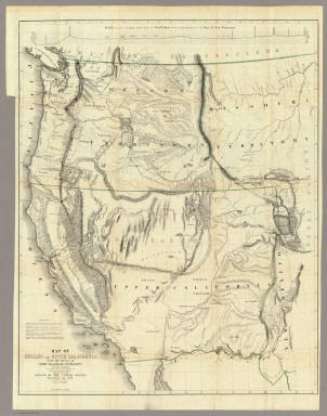
Fremont, J.C.
Full Title
Map Of Oregon And Upper California From the Surveys of John Charles Fremont And other Authorities. Drawn By Charles Preuss Under the Order of the Senate Of The United States, Washington City 1848. Lithy. by E. Weber & Co. Balto. (inset) Profile of the travelling route from the South Pass of the Rocky Mountains to the Bay of San Francisco.
Publisher
Wendell and Van Benthuysen
Author
Hayden, F.V.
Full Title
U.S. War Department Map Of The Yellowstone And Missouri Rivers And Their Tributaries explored by Capt. W.F. Raynolds Topl. Engrs. and 1st Lieut. H.E. Maynadier 10th Infy. Assistant. 1859-60. To accompany a report to the Bureau of Topographical Engineers. Lt. Col. Harman Bache in charge. Engraved in the Engineer Bureau War Dept. Prepared to accompany the Geological Report of F.V. Hayden M.D. ... Printed by Julius Bien, N.Y.
Publisher
Government Printing Office
Author
[Mitchell, Samuel Augustus, Thomas, Cowperthwait & Co.]
Full Title
Geographical Description Of The State Of Texas; Also, Of That Part Of The West Coast Of North America, Which Includes Oregon, And Upper California. With Maps. Philadelphia: Thomas, Cowperthwait & Co. 1846. (on verso) Entered ... 1846, by Thomas, Cowperthwait & Co. ... Pennsylvania. (with) Map Of That Part Of The West Coast Of North America Comprising Oregon And Upper California. (with) Map Of The State Of Texas With Portions Of The Adjoining Regions.
Publisher
Thomas, Cowperthwait & Co.
Author
[Eddy, William M., Jones, William Carey]
Full Title
Official Map of San Francisco, Compiled from the Field Notes of the Official Re-Survey made by William M. Eddy. Surveyor of the Town of San Francisco, California. 1849. S.W. Higgins. Draftn. Copied by P.M. McGill C.E. & Draftn. Washington. C.B. Graham lith. Washington, D.C.
Publisher
U.S.
Author
Morse, Jedidiah
Full Title
A New Map of Nova Scotia, New Brunswick and Cape Breton. 1794. George Allen sculpt. Published October 10, 1794 by J. Stockdale, Piccadilly.
Publisher
John Stockdale
Author
Morse, Jedidiah
Full Title
A Map of Newfoundland. J. Cooke, sct. Hendon. Published by J. Stockdale, Piccadilly, Octr. 4th, 1791.
Publisher
John Stockdale
Author
Morse, Jedidiah
Full Title
A Map of the Northern and Middle States; Comprehending the Western Territory and the British Dominions in North America. from the best Authorities. Engraved by G. Allen, Sadlers Wells Row, Islington. Engraved for Morse's Geography, Published by J. Stockdale Jany. 25, 1792.
Publisher
John Stockdale
Author
Morse, Jedidiah
Full Title
A Map of Vermont. I. Mutlow Sc. Published Octr. 2d, 1794, by I. Stockdale, PIccadilly.
Publisher
John Stockdale
Author
Morse, Jedidiah
Full Title
A Map of New Hampshire. Published July 17, 1794 by I. Stockdale, Piccadilly.
Publisher
John Stockdale
Author
Morse, Jedidiah
Full Title
A Map of Massachusetts from the best Authorities. I. Mutlow Sc. 6 James St. Covt. Gardn. Published July 8, 1794 by I. Stockdale, Piccadilly.
Publisher
John Stockdale
Author
Morse, Jedidiah
Full Title
A Map of Rhode Island. I. Mutlow Sculp. 6 James St. Published July 15, 1794 by I. Stockdale, Piccadilly.
Publisher
John Stockdale
Author
Morse, Jedidiah
Full Title
A Map of Connecticut. J. Roper, sc. Publish'd Augt. 10th 1794, by J. Stockdale, Piccadilly.
Publisher
John Stockdale
Author
Morse, Jedidiah
Full Title
A Map of Kentucky, Drawn from Actual Observations. By John Filson. (with) A Plan of the Rapids, in the River Ohio. Published Novr. 23, 1793, by John Stockdale, Piccadilly.
Publisher
John Stockdale
Author
Morse, Jedidiah
Full Title
A Map of North Carolina from the best Authorities. Harrison sc. Published July 24th 1794 by J. Stockdale Piccadilly.
Publisher
John Stockdale
Author
Morse, Jedidiah
Full Title
A Map of the Tennessee Government. 1794. Published Sep. 20 1794 by I. Stockdale, Piccadilly.
Publisher
John Stockdale
Author
Morse, Jedidiah
Full Title
A Map of South Carolina from the best Authorities. J. Roper, sc. Published July 12, 1794, by J. Stockdale.
Publisher
John Stockdale
Author
Morse, Jedidiah
Full Title
A Map of East and West Florida. Published Octr. 18, 1794, by I. Stockdale, Piccadilly.
Publisher
John Stockdale
Author
Morse, Jedidiah
Full Title
A Map of South America and the Adjacent Islands, 1794. Published Octr. 14, 1794, by I. Stockdale, Piccadilly.
Publisher
John Stockdale
Author
Morse, Jedidiah
Full Title
A Map of the West Indies from the best Authorities. Published July 9, 1794 by I. Stockdale, Piccadilly.
Publisher
John Stockdale
Author
Morse, Jedidiah
Full Title
A Map of the World Exhibiting all the New Discoveries. 1794. Published by J. Stockdale, Piccadilly, 24 Sept. 1794.
Publisher
John Stockdale
Author
[Macomb, J.N., Egloffstein, F.W.]
Full Title
Map of Exploration and Surveys in New Mexico and Utah made under the direction of the Secretary of War by Capt. J.N. Macomb Topl. Engrs. assisted by C.H. Dimmock, C. Engr. 1860. Lettering by John L. Hazzard. Ruling by Samuel Sartain. Constructed and Engraved by Baron F.W. Von Egloffstein.
Publisher
Washington: U.S.
Author
Mullan, John
Full Title
General Map of the North Pacific States and Territories Belonging to the United States and of British Columbia, Extending from Lake Superior to the Pacific Ocean and Between Latitude 39 degrees and 53 degrees North. Exhibiting Mail Routes, Gold Mines, and Including the Most Recent Surveys of the Topographical Bureau. Prepared by Captain John Mullan. ... Drawn by Edward Freyhold, T.E. Lithographed by J. Bien, 24 Vesey, St. N.Y.
Publisher
Wm. M. Franklin
Author
Nicollet, J. N. (Joseph Nicolas), 1786-1843
Full Title
Hydrographical Basin of the Upper Mississippi River From Astronomical and Barometrical Observations Surveys and Information by J.N. Nicollet ... assisted ... by Lieut. J.C. Fremont ... Reduced and compiled under the direction of Col. J.J. Abert in the Bureau of the Corps of Topl. Engrs. by Lieut. W.H. Emory ... 1843 ... W.J. Stone Sc.
Publisher
Blair and Rives
Author
[Jones, T.W., Moore, S.S.]
Full Title
Philadelphia and the commencement of the road to New York. 1. Shallus fc.
Publisher
Mathew Carey
Author
[Jones, T.W., Moore, S.S.]
Full Title
Road from Philadela. to New York. (Maps) 2, 3, 4 and 5. Shallus, fc.
Publisher
Mathew Carey
Author
[Jones, T.W., Moore, S.S.]
Full Title
Road from Philadelphia to New York. (Maps) 7, 6, 8 and 9. N.B. The above Columns (7, 6) are transposed. No. 6 ought to be on the outside. Shallus, fc.
Publisher
Mathew Carey
Author
[Jones, T.W., Moore, S.S.]
Full Title
Road from Philadelphia to New York. (Maps) 10, 11, 12 and 13. W. Harrison, Junr. sc.
Publisher
Mathew Carey
Author
[Jones, T.W., Moore, S.S.]
Full Title
Road from Philadelphia to New York. (Maps) 14 and 15. W. Harrison, Junr. sc. Smither sc.
Publisher
Mathew Carey
Author
[Jones, T.W., Moore, S.S.]
Full Title
Road from Philadelphia to Washington. (Maps) 1, 2, 3 and 4. W. Harrison, Junr. sc.
Publisher
Mathew Carey
Author
[Jones, T.W., Moore, S.S.]
Full Title
Road from Philadelphia to Washington. (Maps) 5, 6, 7 and 8. W. Harrison, Junr. sc.
Publisher
Mathew Carey
Author
[Jones, T.W., Moore, S.S.]
Full Title
Road from Philadelphia to Washington. (Maps) 9, 10, 11 and 12. W. Harrison, Junr. sc.
Publisher
Mathew Carey
|