Browse All

1777 S. extremity of America. Exploration Book A chart of the southern extremity of Ame … |

1777 S. Atlantic discoveries. Exploration Book Chart of the discoveries made in the Sou … |

1785 Kerguelen's Land. Exploration Book Kerguelen's Land called by C. Cook Islan … |

1785 Port Palliser, Christmas Harbour. Exploration Book Sketch of Port Palliser on Kerguelen's-L … |

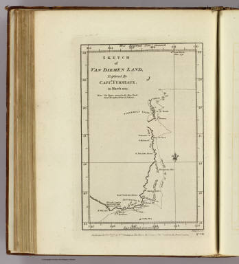
1785 Van Diemen's Land. Exploration Book Chart of Van Diemen's Land. Harmar scrip … |

1785 Adventure Bay, Van Diemens Land. Exploration Book Plan of Adventure Bay in Van Diemens Lan … |

1785 Friendly Islands chart. Exploration Book Chart of the Friendly Islands. Writing b … |

1785 Tongataboo Harbour. Exploration Book Sketch of Tongataboo Harbour, 1777. The … |

1785 (Wanooaette, Wateeoo, Mangeea, Toobouai … Exploration Book (Plans of islands in the South Pacific. … |

1785 Eimeo harbours. Exploration Book Sketch of the harbours on the north side … |

1785 Christmas Island. Exploration Book Christmas Island. Latitude 1058' N. Long … |

1785 Nootka Sound. Exploration Book Sketch of Nootka Sound ... 1778. The wri … |

1785 Cooks River. Exploration Book Chart of Cooks River in the N.W. part of … |

1785 Samaganooda harbour, Oonalaska I. Exploration Book Sketch of the harbour of Samganooda on t … |

1785 Norton Sound, Bherings Strait. Exploration Book Chart of Norton Sound and of Bherings St … |

1785 Sandwich Islands. Exploration Book Chart of the Sandwich Islands. (with) Sk … |

1785 Awatska Bay. Exploration Book Plan of the Bay of Awatska on the east c … |

1785 Typa, Macao. Exploration Book Sketch of the Typa and Macao. (Engraved … |

1785 General chart Cook voyages. Exploration Book A general chart: exhibiting the discover … |

1785 N.W. coast America, N.E. coast Asia. Exploration Book Chart of the N.W. coast of America and N … |

1773 Cordes Bay, Port Famine, Woods Pay, Port … Exploration Book Cordes Bay and Harbour. (with) Port Fami … |

1773 Cape Providence, St. David's Cove, Islan … Exploration Book Cape Providence with the bay and anchori … |

1773 York Bay-Three Island Bay, Elizabeth Bay … Exploration Book From York Bay to Three Island Bay and Ha … |

1773 Hawkins's Maidenland, Falkland Sound. Exploration Book A chart of Hawkins's Maidenland, discove … |

1773 Cocos, Traitors islands. Exploration Book (Cocos Island called by C. Wallis Boscaw … |
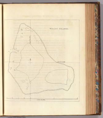
1773 Wallis's Islands. Exploration Book Wallis's Islands. (London: printed for W … |

1773 Queen Charlotte's Islands. Exploration Book Queen Charlotte's Islands. Bayly sculpt. … |
1773 New Britain discoveries. Exploration Book A chart of Captn. Carteret's discoveries … |

1773 Dangerous shoal. Exploration Book A dangerous shoal seen Septr. the 28, 17 … |

1773 Bonthain Bay. Exploration Book A draught of Bonthain Bay situated about … |

1773 Success Bay, Terra del Fuego. Exploration Book A plan of Success Bay in Strait le Maire … |

1773 Otaheite. Exploration Book Chart of the island Otaheite, by Lieut. … |

1773 Society Isles. Exploration Book Chart of the Society Isles, discovered b … |

1773 Matavia Bay, Ohamaneno, Owharre, Oopoa h … Exploration Book Matavia (i.e. Matavai) Bay in Otaheite. … |

1773 New-Zealand chart. Exploration Book Chart of New-Zealand, explored in 1769 a … |

1773 River Thames, Mercury Bay, N.Z. Exploration Book River Thames and Mercury Bay in New Zeal … |

1773 Cook's Strait, N.Z. Exploration Book Chart of Cook's Strait in New Zealand. J … |

1773 New South Wales. Exploration Book A chart of New South Wales, on the east … |

1773 Endeavour R., Botany Bay. Exploration Book Entrance of Endeavour River in New South … |

1773 Cape Tribulation-Endeavour Straits. Exploration Book Chart of part of the coast of New South … |

1777 S. Hemisphere. Exploration Book A chart of the Southern Hemisphere; shew … |

1777 Port Praya, Cape de Verds. Exploration Book Port Praya in the island St. Jago, one o … |

1777 Dusky Bay, N.Z. Exploration Book Sketch of Dusky Bay in New Zeeland; 1773 … |
1777 Van Diemen Land. Exploration Book Sketch of Van Diemen Land, explored by C … |

1777 Friendly Isles. Exploration Book Chart of the Friendly Isles. No. XIV. Pu … |

1777 Easter Island. Exploration Book Easter Island. W. Whitchurch sculpt., 17 … |

1777 Marquesas de Mendoca, Resolution Bay. Exploration Book Sketch of the Marquesas de Mendoca. (wit … |

1777 Harvey's, Palmerston, Turtle, Savage isl … Exploration Book Harvey's Isle. Palmerston Isle. Turtle I … |

1777 Discoveries S. Pacific Ocean. Exploration Book Chart of discoveries made in the South P … |

1777 Port Resolution, Port Sandwich, Balade. Exploration Book Port Resolution in the Isle of Tanna. (w … |