|
|
Author
Bellin, Jacques Nicolas, 1703-1772
Full Title
Plan des Forts et Canal de la Goulette. (engraved by) Croisey.
Publisher
J.N. Bellin
Author
Bellin, Jacques Nicolas, 1703-1772
Full Title
Plan de la Rade et Ville de Tripoli à la Coste de Barbarie.
Publisher
J.N. Bellin
Author
Bellin, Jacques Nicolas, 1703-1772
Full Title
Costes D'Egypte Depuis Alexandrie Jusqu'À Rosette.
Publisher
J.N. Bellin
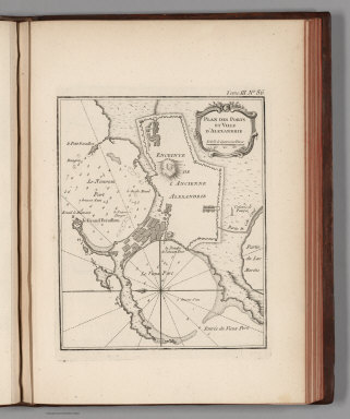
Author
Bellin, Jacques Nicolas, 1703-1772
Full Title
Plan des Ports et Ville d'Alexandrie.
Publisher
J.N. Bellin
Author
Bellin, Jacques Nicolas, 1703-1772
Full Title
Rade du Bequier. (engraved by) Croisey.
Publisher
J.N. Bellin
Author
Bellin, Jacques Nicolas, 1703-1772
Full Title
Plan du Fort et du Village du Bequier. (engraved by) Croisey.
Publisher
J.N. Bellin
Author
Bellin, Jacques Nicolas, 1703-1772
Full Title
Carte Des Embouchures Du Nil, Et Partie De Son Cours, Le Delta et l'Isthme de Suez.
Publisher
J.N. Bellin
Author
Bellin, Jacques Nicolas, 1703-1772
Full Title
Carte Exacte Du Cours Du Nil.
Publisher
J.N. Bellin
Author
Bellin, Jacques Nicolas, 1703-1772
Full Title
Carte reduite de la Mer Mediterranee.
Publisher
J.N. Bellin
Author
Bellin, Jacques Nicolas, 1703-1772
Full Title
Carte des Royaumes de Fez et de Maroc.
Publisher
J.N. Bellin
Author
Bellin, Jacques Nicolas, 1703-1772
Full Title
Isle de Mogador ses Mouillages et son Port.
Publisher
J.N. Bellin
Author
Bellin, Jacques Nicolas, 1703-1772
Full Title
Carte des Isles Canaries.
Publisher
J.N. Bellin
Author
Bellin, Jacques Nicolas, 1703-1772
Full Title
Carte de I'isle de Teneriffe : Suivant les observations astronomiques et les journaux de navigateurs.
Publisher
J.N. Bellin
Author
Bellin, Jacques Nicolas, 1703-1772
Full Title
Carte De L'Entree De La Riviere De Sanaga ou Senegal.
Publisher
J.N. Bellin
Author
Bellin, Jacques Nicolas, 1703-1772
Full Title
Cours de la Riviere de Sanaga ou Senegal Depuis son Embouch.re Jusqu'a I'Isle de Bilbas. Levepar un Ingenieur Francois en 1718 : Suite du Cours de la Riviere de Senegal Depuis l'Isle de Bilbas Jusqu'au Sault du Rocher de Govina.
Publisher
J.N. Bellin
Author
Bellin, Jacques Nicolas, 1703-1772
Full Title
Suite Du Cours de la Riviere de Senegal depuis I'Isle de Bilbas Jusquau Sault du Rocher de Govina
Publisher
J.N. Bellin
Author
Bellin, Jacques Nicolas, 1703-1772
Full Title
Plan de la Baye et Isle d'Arguim. Leve par un Pilote francois. (engraved by) Croisey.
Publisher
J.N. Bellin
Author
Bellin, Jacques Nicolas, 1703-1772
Full Title
Costes d'Afrique depuia le Cap Verd jusquau Cap Verga. (engraved by) Croisey.
Publisher
J.N. Bellin
Author
Bellin, Jacques Nicolas, 1703-1772
Full Title
Plan de l'Isle de Gore avec ses Fortifications.
Publisher
J.N. Bellin
Author
Bellin, Jacques Nicolas, 1703-1772
Full Title
Carte des Isles du Cap Verd.
Publisher
J.N. Bellin
Author
Bellin, Jacques Nicolas, 1703-1772
Full Title
Carte De La Riviere De Gambra ou Gambie : depuis son Embouchure jusqua Eropina.
Publisher
J.N. Bellin
Author
Bellin, Jacques Nicolas, 1703-1772
Full Title
Carte Du Cours De La Riviere De Gambra ou Gambie : depuis Eropina jusqua Barrakonda.
Publisher
J.N. Bellin
Author
Bellin, Jacques Nicolas, 1703-1772
Full Title
Carte De L'Entrée De La Riviere De Sierra Leona. (inset) Plan de l'Isle de Bense.
Publisher
J.N. Bellin
Author
Bellin, Jacques Nicolas, 1703-1772
Full Title
Entree De La Riviere De Sestos. (engraved by) Croisey. (inset) Vue du Cap Mesurado, et ses Environs.
Publisher
J.N. Bellin
Author
Bellin, Jacques Nicolas, 1703-1772
Full Title
Partie de la Coste de Guinee depuis la Riviere de Sierra Leona jusquau Cap das Palmas.
Publisher
J.N. Bellin
Author
Bellin, Jacques Nicolas, 1703-1772
Full Title
Coste De Guinee : Depuis le Cap Apollonia jusqua la Riviere de Volta Ou La Coste D'Or.
Publisher
J.N. Bellin
Author
Bellin, Jacques Nicolas, 1703-1772
Full Title
Carte Du Golfe De Benin Et Partie De La Cote De Guinee : Depuis la Riviere de Volta Jusquau C. Formosa. (engraved by) Croisey,
Publisher
J.N. Bellin
Author
Bellin, Jacques Nicolas, 1703-1772
Full Title
Carte De La Riviere de Kalbar, Appellee communement ou Rio Real; avec les cotes voismes. Tirees des Remarques de plusieurs Pilotes en 1699.
Publisher
J.N. Bellin
Author
Bellin, Jacques Nicolas, 1703-1772
Full Title
Carte des Royaumes de Congo, Angola et Benguela avec les pays Voisins : Tire de l'Anglois.
Publisher
J.N. Bellin
Author
Bellin, Jacques Nicolas, 1703-1772
Full Title
Rade De Benguela Et Riviere De Cantonbelle.
Publisher
J.N. Bellin
Author
Bellin, Jacques Nicolas, 1703-1772
Full Title
Carte Du Pais Des Hottentots : aux Environs du Cap de Bonne Esperance.
Publisher
J.N. Bellin
Author
Bellin, Jacques Nicolas, 1703-1772
Full Title
Baye De Saldane : au Nord-Ouest du Cap de Bonne Esperance.
Publisher
J.N. Bellin
Author
Bellin, Jacques Nicolas, 1703-1772
Full Title
Carte De La Baye De La Table, Et Rade Du Cap De Bonne Esperance.
Publisher
J.N. Bellin
Author
Bellin, Jacques Nicolas, 1703-1772
Full Title
Plan du Fort et de la Ville du Cap de Bonne Esperance.
Publisher
J.N. Bellin
Author
Bellin, Jacques Nicolas, 1703-1772
Full Title
Carte de L'Isle de Madagascar et du Canal de Mozambique.
Publisher
J.N. Bellin
Author
Bellin, Jacques Nicolas, 1703-1772
Full Title
Carte de L'Ance Dauphine dans l'Isle de Madagascar.
Publisher
J.N. Bellin
Author
Bellin, Jacques Nicolas, 1703-1772
Full Title
Carte de la Baye d'Antongil dans l'Isle de Madagascar.
Publisher
J.N. Bellin
Author
Bellin, Jacques Nicolas, 1703-1772
Full Title
Carte de la Baye de Mosambique.
Publisher
J.N. Bellin
Author
Bellin, Jacques Nicolas, 1703-1772
Full Title
Carte de L'Isle de France.
Publisher
J.N. Bellin
Author
Bellin, Jacques Nicolas, 1703-1772
Full Title
Plan du Port Bourbon en l'Isle de France. (engraved by) Croisey.
Publisher
J.N. Bellin
Author
Bellin, Jacques Nicolas, 1703-1772
Full Title
Plan du Port Louis dans l'Isle de France.
Publisher
J.N. Bellin
Author
Bellin, Jacques Nicolas, 1703-1772
Full Title
Carte de l'Isle de Bourbon autrefois Mascareigne.
Publisher
J.N. Bellin
Author
Bellin, Jacques Nicolas, 1703-1772
Full Title
Plan de l'Isle Ste Helene.
Publisher
J.N. Bellin
Author
Vancouver, George, 1757-1798
Full Title
A Chart shewing part of the Coast of N.W. America, with the tracks of His Majesty's Sloop Discovery and Armed Tender Chatham; Commanded by George Vancouver Esqr. and prepared under his immediate inspection by Lieut. Joseph Baker, in which the Continental Shore has been traced and determined from Lat. 51¼45'N. and Long. 232¼08' E. to Lat. 57¼30'N and Long 226¼44'E. at the different periods shown by the Tracks. Warner Sculp. 7. (with) A Survey of Port Stewart. London: Published May 1st 1798, by J. Edwards Pall Mall & G. Robinson Paternoster Row.
Publisher
G.G. & J. Robinson
Author
Vancouver, George, 1757-1798
Full Title
A Chart shewing part of the Coast of N.W. America, With the Tracks of His Majesty's Sloop Discovery and Armed Tender Chatham; Commanded by George Vancouver Esqr. and prepared under his immediate inspection by Lieut. Joseph Baker, in which the Continental Shore has been traced and determined from Lat. 30¼00'N. and Long. 244¼32' E. to Lat. 38¼30'N and Long 237¼13'E. Engraved by T. Foot, Weston Place, Battle Bridge. No. 8. (with) Entrance of Port Sn. Francisco. (and) Port Sn. Diego. London: Published May 1st 1798, by J. Edwards Pall Mall & G. Robinson Paternoster Row.
Publisher
G.G. & J. Robinson
Author
Vancouver, George, 1757-1798
Full Title
A Chart shewing part of the Coast of N.W. America, With the Tracks of His Majesty's Sloop Discovery and Armed Tender Chatham; Commanded by George Vancouver Esqr. and prepared under his immediate inspection by Lieut. Joseph Baker, in which the Continental Shore has been traced and determined from Latde. of 59¼30' North & Longde. 207¼20' East; to Cape Douglas in Latde. 58¼52' North and Longde. 207¼20' East. Engraved by S.J. Neele, 352 Strand. (with) A Survey of Port Chatham. London Published May 1st 1798, by T.R. Edwards Pall Mall & C. Robinson Paternoster Row.
Publisher
G.G. & J. Robinson
Author
Vancouver, George, 1757-1798
Full Title
A Chart Shewing part of the Coast of N.W. America, With the Tracks of His Majesty's Sloop Discovery and Armed Tender Chatham; Commanded by George Vancouver Esqr. and prepared under his immediate inspection by Lieut. Joseph Baker, in which the Continental Shore has been traced and determined from Latd. 59¼45'N. and Longd. 219¼30'E. to Latd. 59¼56'N and Longd. 212¼08'E. at the periods shewn by the Track. No. 11. (with) A Survey of Port Chalmers. Engraved by T. Foot, Weston Place, St. Pancras. London. Published May 1st 1798, by J. Edwards, Pall Mall & G. Robinson, Paternoster Row.
Publisher
G.G. & J. Robinson
Author
Vancouver, George, 1757-1798
Full Title
A Chart Shewing part of the Coast of N.W. America, With the Tracks of His Majesty's Sloop Discovery and Armed Tender Chatham; Commanded by George Vancouver Esqr. and prepared under his immediate inspection by Lieut. Joseph Baker, in which the Continental Shore has been traced and determined from Latde. 57¼07'1/2N. and Longd. 227¼00'E. to Latd. 59¼39'N and Longd. 219¼00'E. at the periods shewn by the Track. No. 12. (with) three inset maps. Engraved by T. Foot, Weston Place, St. Pancras. London: Published May 1st 1798, by J. Edwards Pall Mall & G. Robinson Paternoster Row.
Publisher
G.G. & J. Robinson
Author
Vancouver, George, 1757-1798
Full Title
A Chart Shewing part of the Coast of N.W. America, With the Tracks of His Majesty's Sloop Discovery and Armed Tender Chatham; Commanded by George Vancouver Esqr. and prepared from the foregoing Surveys under his immediate inspection by Lieut. Edwd. Roberts in which the Continental Shore has been correctly Traced and Determined From Lat. 29¼54'N. and Long. 244¼33'E. to Cape Douglas in Lat. 58¼52'N and Longd. 207¼20'E. during the Summers of 1792, 1793, and 1794. 14. Warner Sculp. London: Published May 1st 1798, by J. Edwards Pall Mall & G. Robinson Paternoster Row.
Publisher
G.G. & J. Robinson
Author
Vancouver, George, 1757-1798
Full Title
Views of the Sandwich and other Islands. 16. W. Alexander delt. from Sketches made on the spot. London: Published May 1st 1798, by J. Edwards Pall Mall and G. Robinson Paternoster Row. B.T. Pouncy sculp.
Publisher
G.G. & J. Robinson
|