|
REFINE
Browse All : Chart Map from 1777
1-16 of 16
Author
[Blaskowitz, Charles, Faden, William, 1750?-1836]
Full Title
A Topographical Chart of the Bay of Narraganset in the Province of New England, with all the Isles contained therein, among which Rhode Island and Connonicut have been particularly Surveyed, Shewing the true position & bearings of the Banks, Shoals, Rocks &c. as likewise the Soundings: To which have been added the several Works & Batteries raised by the Americans. Taken by Order of the Principal Farmers on Rhode Island, By Charles Blaskowitz. Engraved & Printed for Wm. Faden, Charing Cross, as the Act directs, July 22d 1777. To the Right Honourable Hugh Earl Percy, Baron Percy, Lucy, Poinings, Fitz-Paine, Bryan & Latimer, Lieutenant General of His Majesty's Forces in Great Britain and America. This Plan is ... most humbly Inscribed, by ... Wm. Faden. (in manuscript) Hinck S.
Publisher
William Faden
Author
[Blaskowitz, Charles, Faden, William, 1750?-1836]
Full Title
(Covers to) A Topographical Chart of the Bay of Narraganset in the Province of New England, with all the Isles contained therein, among which Rhode Island and Connonicut have been particularly Surveyed, Shewing the true position & bearings of the Banks, Shoals, Rocks &c. as likewise the Soundings: To which have been added the several Works & Batteries raised by the Americans. Taken by Order of the Principal Farmers on Rhode Island, By Charles Blaskowitz. Engraved & Printed for Wm. Faden, Charing Cross, as the Act directs, July 22d 1777. To the Right Honourable Hugh Earl Percy, Baron Percy, Lucy, Poinings, Fitz-Paine, Bryan & Latimer, Lieutenant General of His Majesty's Forces in Great Britain and America. This Plan is ... most humbly Inscribed, by ... Wm. Faden. (in manuscript) Hinck S.
Publisher
William Faden
Author
Cook, James, 1728-1779
Full Title
A chart of the southern extremity of America 1775. (with) Part of Staten Land. No. II. Published Febry. 1st, 1777 by Wm. Strahan in New Street, Shoe Lane & Thos. Cadell in the Strand, London.
Publisher
W. Strahan and T. Cadell
Author
Cook, James, 1728-1779
Full Title
Chart of the discoveries made in the South Atlantic Ocean in his majesty's ship Resolution, under the command of Captain Cook in Jany. 1775. J. Russell sculp. No. IV. Published Febry. 1st, 1777 by Wm. Strahan in New Street, Shoe Lane & Thos. Cadell in the Strand, London.
Publisher
W. Strahan and T. Cadell
Author
Cook, James, 1728-1779
Full Title
A chart of the Southern Hemisphere; shewing the tracks of some of the most distinguished navigators: by Captain James Cook of his Majesty's Navy. Gulielmus Whitchurch, sculpsit; Anno. 1776. Published Febry. 1st., 1777 by Wm. Strahan in New Street, Shoe Lane & Thos. Cadell in the Strand, London.
Publisher
W. Strahan and T. Cadell
Author
Cook, James, 1728-1779
Full Title
Port Praya in the island St. Jago, one of the Cape de Verds. Published Feby. 1st., 1777 by Wm. Strahan in New Street, Shoe Lane & Thos. Cadell in the Strand, London. No. X.
Publisher
W. Strahan and T. Cadell
Author
Cook, James, 1728-1779
Full Title
Sketch of Dusky Bay in New Zeeland; 1773. (with) Pickersgill Harbour. W. Whitchurch sculpsit, Islington, 1776. No. XIII. Published Febry. 1st., 1777 by Wm. Strahan in New Street, Shoe Lane & Thos. Cadell in the Strand, London.
Publisher
W. Strahan and T. Cadell
Author
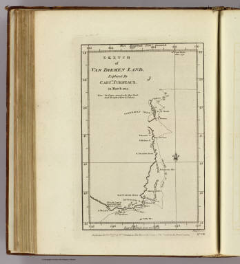
Furneaux, Tobias, 1735-1781
Full Title
Sketch of Van Diemen Land, explored by Captn. Furneaux, in March 1773. J Russell sculpt. No. VIII. Published Febry. 1st., 1777, by Wm. Strahan in New Street, Shoe Lane & Thos. Cadell in the Strand, London.
Publisher
W. Strahan and T. Cadell
Author
Cook, James, 1728-1779
Full Title
Chart of the Friendly Isles. No. XIV. Published Febry. 1st, 1777 by Wm. Strahan in New Street, Shoe Lane & Thos. Cadell in the Strand, London.
Publisher
W. Strahan and T. Cadell
Author
Cook, James, 1728-1779
Full Title
Easter Island. W. Whitchurch sculpt., 1776. Published Febry. 1st, 1777 by Wm. Strahan in New Street, Shoe Lane & Thos. Cadell in the Strand, London. No. IX.
Publisher
W. Strahan and T. Cadell
Author
Cook, James, 1728-1779
Full Title
Sketch of the Marquesas de Mendoca. (with) Resolution Bay or Port Madre de Dios. J. Russell sculpsit. No. V. Published Febry. 1st, 1777 by Wm. Strahan in New Street, Shoe Lane & Thos. Cadell in the Strand, London.
Publisher
W. Strahan and T. Cadell
Author
Cook, James, 1728-1779
Full Title
Harvey's Isle. Palmerston Isle. Turtle Isle. Savage Isle. No. XII. Published Febry. 1st, 1777 by Wm. Strahan in New Street, Shoe Lane & Thos. Cadell in the Strand, London.
Publisher
W. Strahan and T. Cadell
Author
Cook, James, 1728-1779
Full Title
Chart of discoveries made in the South Pacific Ocean in his majesty's ship Resolution under the command of Captain Cook, 1774. Published as the act directs Feby. 1st, 1776. Engraved by W. Palmer. Published Febry. 1st, 1777 by Wm. Strahan in New Street, Shoe Lane & Thos. Cadell in the Strand, London.
Publisher
W. Strahan and T. Cadell
Author
Cook, James, 1728-1779
Full Title
Port Resolution in the Isle of Tanna. (with) Port Sandwich in Mallicollo. (with) Harbour of Balade in New Caledonia. No. XI. Published Febry. 1st, 1772 by Wm. Strahan in New Street, Shoe Lane & Thos. Cadell in the Strand, London.
Publisher
W. Strahan and T. Cadell
Author
Cook, James, 1728-1779
Full Title
Norfolk Isle. No. VI. Published Febry. 1st, 1777 by Wm. Strahan in New Street, Shoe Lane & Thos. Cadell in the Strand, London.
Publisher
W. Strahan and T. Cadell
Author
Cook, James, 1728-1779
Full Title
Christmas Sound on the S.W. coast of Terra (sic) del Fuego. No. VII. Published Febry. 1st, 1777 by Wm. Strahan in New Street, Shoe Lane & Thos. Cadell in the Strand, London.
Publisher
W. Strahan and T. Cadell
1-16 of 16
|