Browse All

1777 Topographical Chart of the Bay of Narrag … [Case Map, Chart Map] A Topographical Chart of the Bay of Narr … |

1777 Cover: Narraganset Bay topographical cha … [Case Map, Chart Map] (Covers to) A Topographical Chart of the … |

1777 S. extremity of America. Exploration Book A chart of the southern extremity of Ame … |

1777 S. Atlantic discoveries. Exploration Book Chart of the discoveries made in the Sou … |

1777 S. Hemisphere. Exploration Book A chart of the Southern Hemisphere; shew … |

1777 Port Praya, Cape de Verds. Exploration Book Port Praya in the island St. Jago, one o … |

1777 Dusky Bay, N.Z. Exploration Book Sketch of Dusky Bay in New Zeeland; 1773 … |
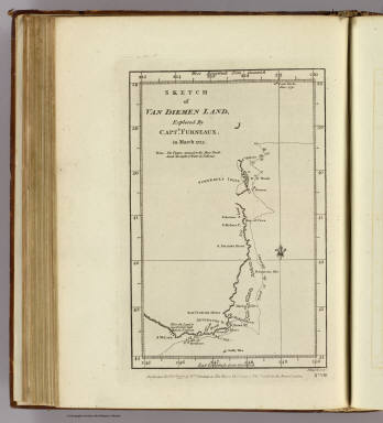
1777 Van Diemen Land. Exploration Book Sketch of Van Diemen Land, explored by C … |

1777 Friendly Isles. Exploration Book Chart of the Friendly Isles. No. XIV. Pu … |

1777 Easter Island. Exploration Book Easter Island. W. Whitchurch sculpt., 17 … |

1777 Marquesas de Mendoca, Resolution Bay. Exploration Book Sketch of the Marquesas de Mendoca. (wit … |

1777 Harvey's, Palmerston, Turtle, Savage isl … Exploration Book Harvey's Isle. Palmerston Isle. Turtle I … |

1777 Discoveries S. Pacific Ocean. Exploration Book Chart of discoveries made in the South P … |

1777 Port Resolution, Port Sandwich, Balade. Exploration Book Port Resolution in the Isle of Tanna. (w … |

1777 Norfolk Isle. Exploration Book Norfolk Isle. No. VI. Published Febry. 1 … |

1777 Christmas Sound, Terra del Fuego. Exploration Book Christmas Sound on the S.W. coast of Ter … |