Who What Where WhenWHO
|
Author
[Wilkes, Charles, United States Exploring Expedition]
Full Title
Grays Harbour, Oregon Territory by the U.S.Ex.Ex. 1841.
Publisher
C. Sherman
Author
[Wilkes, Charles, United States Exploring Expedition]
Full Title
Chart of the Harbour of Waiakea, Island of Hawaii, Surveyed by the U.S.Ex.Ex. 1841.
Publisher
C. Sherman
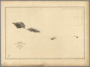
Author
[Wilkes, Charles, United States Exploring Expedition]
Full Title
Samoan or Navigator Islands by the U.S. Ex.Ex., Charles Wilkes Esq. Commander 1839.
Publisher
C. Sherman
Author
[Wilkes, Charles, United States Exploring Expedition]
Full Title
Harbour of Pago Pago, Island of Tutuila by the U.S.Ex.Ex. 1839.
Publisher
C. Sherman
Author
[Wilkes, Charles, United States Exploring Expedition]
Full Title
Port Ludlow, Hoods Canal, Oregon Territory by the U.S.Ex.Ex. 1841. Port Gamble, Hoods Canal, Oregon Territory by the U.S.Ex.Ex. 1841.
Publisher
C. Sherman
Author
[Wilkes, Charles, United States Exploring Expedition]
Full Title
St. Juan Harbour, Straits of Fuca, Vancouver Island by the U.S.Ex.Ex. 1841. Scarborough Harbour, Straits of Fuca, Oregon Territory by the U.S.Ex.Ex. 1841. Port Discovery, Straits of Fuca, Oregon Territory by the U.S.Ex.Ex. 1841.
Publisher
C. Sherman
Author
[Wilkes, Charles, United States Exploring Expedition]
Full Title
Channel of the North Side of Vanua Levu from Muthuata Island to Ivaca Peak, Feejee (Fiji) Islands by the U.S.Ex.Ex. 1840.
Publisher
C. Sherman
Author
[Wilkes, Charles, United States Exploring Expedition]
Full Title
Channel on the South Western Side of Vanua Levu from Ivaca Peak to Savu Savu Bay, Feejee (Fiji) Islands by the U.S.Ex.Ex. 1840.
Publisher
C. Sherman
Author
[Wilkes, Charles, United States Exploring Expedition]
Full Title
Island of Upolu, Samoan Group by the U.S. Ex.Ex. 1839.
Publisher
C. Sherman
Author
[Wilkes, Charles, United States Exploring Expedition]
Full Title
Scabock Harbour, Hoods Canal, Oregon Territory by the U.S.Ex.Ex. 1841. Hooetzen Harbour, Hoods Canal, Oregon Territory by the U.S.Ex.Ex. 1841. Tzu-Sa-Ted Cove, Hoods Canal, Oregon Territory by the U.S.Ex.Ex. 1841.
Publisher
C. Sherman
Author
Bache, A. D.
Full Title
The Harbor of Hyannis. From a trigonometrical survey under the direction of A.D. Bache, Superintendent of the Survey of the Coast of the United States. Triangulation by C.M. Eakin assistant. Topography by W.M. Boyce assistant. Hydrography by J.N. Maffitt, Lieut. U.S. Navy, under the direction of Chas. H. Davis, Lieutenant U.S. Navy. Published in 1850. Reduction by Wm. Luce draughtsman. Engraved by Sherman & Smith, N.Y. Sailing directions &c. by W. Smith U.S.C.S. Electrotype copy no. 1 by G. Mathiot, U.S.C.S. (with logo) U.S. Coast Survey Office.
Publisher
U.S.
Author
Bache, A. D.
Full Title
The harbor of New Bedford. Founded upon a trigonometrical survey under the direction of Alex. D. Bache, Superintendent of the Survey of the Coast of the United States. Triangulation by C.M. Eakin assistant. Topography by H.L. Whiting assistant. Hydrography under the direction of G.S. Blake, Lieut. Comg., U.S. Navy. Published in 1846. Republished in 1850. Drawn by H.L. Whiting assistant. Engraved by Sherman & Smith, New York. Printed by H. Benner. Electrotype copy no. 5 by G. Mathiot, U.S.C.S. (with logo) U.S. Coast Survey Depot.
Publisher
U.S.
Author
Bache, A. D.
Full Title
Pasquotank River. From a trigonometrical survey under the direction of A.D. Bache, Superintendent of the Survey of the Coast of the United States. Triangulation by W.M. Boyce and J.C. Neilson, assistants. Topography by J.C. Neilson, assistant. Hydrography by the party under the command of W.P. McArthur, Lieutenant, U.S. Navy. Published in 1850. Drawn by J.H. Adams, draughtsman. Engraved by W. Smith and S.T. Pettit. Electrotype copy no. 1 by G. Mathiot, U.S.C.S. (with logo) U.S. Coast Survey Depot.
Publisher
U.S.
Author
Bache, A. D.
Full Title
Cat and Ship Island harbors. From a trigonometrical survey under the direction of A.D. Bache, Superintendent of the Survey of the Coast of the United States. Main triangulation by F.H. Gerdes, assistant. Secondary triangulation by J.E. Hilgard, assistant. Topography by W.E. Greenwell, assistant. Hydrography by the party under the command of C.P. Patterson, Lieut. U.S. Navy. Published in 1850. Reduction for engraving by Chas. Mahon, draughtsman. Engraved by Sherman & Smith, N.Y. Title & sailing directions &c. by J. Knight U.S.C.S. Electrotype copy no. 1 by G. Mathiot, U.S.C.S. (with logo) U.S. Coast Survey Office.
Publisher
U.S.
|