Who What Where WhenREMOVE |
REFINE
Browse All : Chart Map of Africa and Mediterranean Sea
1-5 of 5
Author
Bellin, Jacques Nicolas, 1703-1772
Full Title
Plan de la Ville Fort et Port d'Alger.
Publisher
J.N. Bellin
Author
Bellin, Jacques Nicolas, 1703-1772
Full Title
Plan de l'isle de Tabarque à la coste de Barbarie.
Publisher
J.N. Bellin
Author
Bellin, Jacques Nicolas, 1703-1772
Full Title
Plan de port Farine.
Publisher
J.N. Bellin
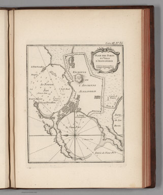
Author
Bellin, Jacques Nicolas, 1703-1772
Full Title
Plan des Ports et Ville d'Alexandrie.
Publisher
J.N. Bellin
Author
[Delarochette, Louis Stanislas d'Arcy, Faden, William, 1750?-1836]
Full Title
A chart of the coasts of Spain and Portugal, with the Balearic Islands, and part of the coast of Barbary. By L.S. De la Rochette. MDCCLXXX. 2d. edition. London: engraved & published as the Act directs, by Wm. Faden, successr. to the late T. Jefferys, Geogr. to the King. Charing Cross, June 28th, 1780.
Publisher
William Faden
1-5 of 5
|