Browse All

1836 A New Chart of The Pacific Ocean (Southe … Chart Map A New Chart of The Pacific Ocean, Exhibi … |

1836 Composite: A New Chart of The Pacific Oc … Chart Map (Composite of) A New Chart of The Pacifi … |

1870 Chart of the Indian and Part of the Paci … Chart Map A General Chart of the Indian and Part o … |

1799 Route of the Spanish frigate la Princesa … Exploration Book Part of the Great Pacific Ocean showing … |

1785 Van Diemen's Land. Exploration Book Chart of Van Diemen's Land. Harmar scrip … |

1785 Adventure Bay, Van Diemens Land. Exploration Book Plan of Adventure Bay in Van Diemens Lan … |

1773 New South Wales. Exploration Book A chart of New South Wales, on the east … |

1773 Endeavour R., Botany Bay. Exploration Book Entrance of Endeavour River in New South … |

1773 Cape Tribulation-Endeavour Straits. Exploration Book Chart of part of the coast of New South … |
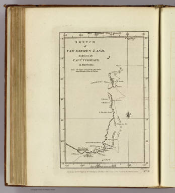
1777 Van Diemen Land. Exploration Book Sketch of Van Diemen Land, explored by C … |