Who What Where WhenWHO
|
REFINE
Browse All : Chart Map of Australia
1-10 of 10
Author
Norie, J.W.
Full Title
A New Chart of The Pacific Ocean, Exhibiting The Western Coast of America, From Cape Horn To Beerings Strait, The Eastern Shores of Asia Including Japan, China and Australia, and all the numerous Islands and known Dangers Situated in Polynesia and Australasia, Correctly Drawn And Regulated according to the most Approved and Modern Surveys and Astronomical Observations By J.W. Norie, Hydrographer, &c.&c. Additions 1836. Stephenson, Engraver. London. Published ... October 1st 1825, by J.W. Norie & Co. (with) seven inset maps listed in Notes. (Southern Sheet)
Publisher
J.W. Norie & Co.
Author
Norie, J.W.
Full Title
(Composite of) A New Chart of The Pacific Ocean, Exhibiting The Western Coast of America, From Cape Horn To Beerings Strait, The Eastern Shores of Asia Including Japan, China and Australia, and all the numerous Islands and known Dangers Situated in Polynesia and Australasia, Correctly Drawn And Regulated according to the most Approved and Modern Surveys and Astronomical Observations By J.W. Norie, Hydrographer, &c.&c. Additions 1836. Stephenson, Engraver. London. Published ... October 1st 1825, by J.W. Norie & Co. (with) seven inset maps listed in Notes. (Northern and Southern Sheets)
Publisher
J.W. Norie & Co.
Author
[Norie, J.W., Hobbs, J.S., Wilson, Charles]
Full Title
A General Chart of the Indian and Part of the Pacific Oceans, Shewing the Various Passages to & from China, Australia, New Zealand, &c. Carefully Constructed & Compiled from the most approved Observations and Modern Surveys, by J.S. Hobbs, F.R.G.S. Hydrographer. London, Published as the Act directs, March 1st 1850 by Charles Wilson, Late J.W. Norie & Wilson, at the Navigation Warehouse and Naval Academy, No. 157 Leadenhall Street. Additions 1870.
Publisher
Charles Wilson
Author
La Perouse, Jean-Francois de Galaup, comte de, 1741-1788
Full Title
Part of the Great Pacific Ocean showing the Route of the Spanish frigate la Princesa commanded by D. Franco. Antonio Maurelle in 1781. Published as the Act directs Novr. 1st ,1798, by G.G. & J. Robinson, Paternoster Row. Neele Sc., Strand. No. 68.
Publisher
G.G. & J. Robinson.
Author
[Bligh, William, 1754-1817, Cook, James, 1728-1779]
Full Title
Chart of Van Diemen's Land. Harmar script. (By William Bligh. London, G. Nicol and T. Cadell, 1785)
Publisher
G. Nicol and T. Cadell
Author
Cook, James, 1728-1779
Full Title
Plan of Adventure Bay in Van Diemens Land. (with) View of the south side of Adventure Bay. (Copied by Lieut. Henry Roberts. London, G. Nicol and T. Cadell, 1785)
Publisher
G. Nicol and T. Cadell
Author
[Cook, James, 1728-1779, Hawkesworth, John, 1715?-1773]
Full Title
A chart of New South Wales, on the east coast of New-Holland. Discovered and explored by Lieutenant J: Cook, Commander of his Majesty's Bark Endeavour, in the year MDCCLXX. Engraved by W. Whitchurch, Bartholomew Lane, Royal Exchange. (London: printed for W. Strahan; and T. Cadell in the Strand, MDCCLXXIII).
Publisher
W. Strahan and T. Cadell
Author
[Cook, James, 1728-1779, Hawkesworth, John, 1715?-1773]
Full Title
Entrance of Endeavour River in New South Wales. Botany Bay in New South Wales. J. Gibson & T. Bowen sculp. (London: printed for W. Strahan; and T. Cadell in the Strand, MDCCLXXIII).
Publisher
W. Strahan and T. Cadell
Author
[Cook, James, 1728-1779, Hawkesworth, John, 1715?-1773]
Full Title
Chart of part of the coast of New South Wales, from Cape Tribulation to Endeavour Straits, by Lieut. J. Cook, 1770. J. Cheevers sculpt. (London: printed for W. Strahan; and T. Cadell in the Strand, MDCCLXXIII).
Publisher
W. Strahan and T. Cadell
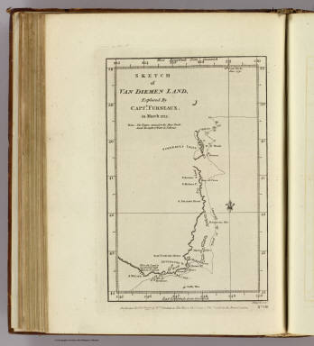
Author
Furneaux, Tobias, 1735-1781
Full Title
Sketch of Van Diemen Land, explored by Captn. Furneaux, in March 1773. J Russell sculpt. No. VIII. Published Febry. 1st., 1777, by Wm. Strahan in New Street, Shoe Lane & Thos. Cadell in the Strand, London.
Publisher
W. Strahan and T. Cadell
1-10 of 10
|