Who What Where WhenREMOVE |
REFINE
Browse All : Chart Map of Chesapeake Bay
1-3 of 3
Author
Lucas, Fielding Jr.
Full Title
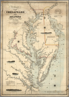
A Chart of the Chesapeake And Delaware Bays Compiled And Published By Fielding Lucas Junr. Baltimore. Corrected_1862. Engraved by John and William W. Warr Philadelphia. Sold by Lucas Brothers. Drawn by F. Lucas Jr. Entered ... 1852 by Fielding Lucas Jr. ... Maryland.
Publisher
Fielding, Lucas Jr.
Author
Lucas, Fielding Jr.
Full Title
A Chart of the Chesapeake And Delaware Bays Compiled And Published By Fielding Lucas Junr. Baltimore Corrected_1840. Engraved by John and William Warr Philadelphia. Entered ... 1832 by Fielding Lucas Jr. ... Maryland.
Publisher
Fielding Lucas Jr.
Author
[Adams, D. P., Blunt, Edmund M. (Edmund March), 1770-1862]
Full Title
The harbour of New York surveyed by Edmund Blunt. (with) Entrance fo the Chesapeake Bay, reduced from the surveys made by D.P. Adams and others by order of the Navy Commissioners of the U.S. by E. Blunt. (with) Views of land between Cape Henlopen and Cape Charles. (insets on 1st sheet of : The coast of the United States of North America; from New York to St. Augustine drawn and regulated according the the latest surveys and astronomical observations by Edmund Blunt). New York: published and sold by E. & G.W. Blunt, 154 Water Street cor. of Maiden Lane. Engraved & printed by W. Hooker, 202 Water Street, New York, 1827.
Publisher
E. & G.W. Blunt.
1-3 of 3
|