Browse All
1862 A Chart of the Chesapeake And Delaware B … Chart Map A Chart of the Chesapeake And Delaware B … |

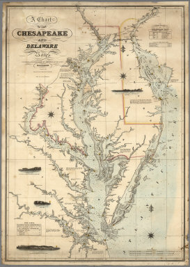
1840 A Chart of the Chesapeake And Delaware B … Chart Map A Chart of the Chesapeake And Delaware B … |

1852 Coast of Delaware, Maryland, pt. of Virg … Chart Atlas Sea Coast of Delaware, Maryland and part … |

1846 Harbor of Annapolis. Chart Atlas The Harbor of Annapolis. Founded upon a … |

1849 Mouth, Chester River. Chart Atlas Mouth of Chester River. (Harbor of refug … |

1764 Carte de la Virginie Mari-land & a. Chart Atlas Carte de la Virginie Mari-land & a. |