Browse All

1825 Carta Esferica de las Costas Y Golfo De … Chart Map Carta Esferica de las Costas Y Golfo De … |

1803 Chart Of The West Indies And Spanish Dom … Chart Map Chart Of The West Indies And Spanish Dom … |

1828 Cote NO, l'Amerique 1. Chart Atlas Cote nord-ouest de l'Amerique. Reconnue … |

1826 Californie, cotes, Golfe du. Chart Atlas Carte reduite des cotes et du Golfe du C … |

1823 Cote du Mexique. Chart Atlas Carte reduite de la cote du Mexique sur … |

1797 St. Diego, St. Blas. Chart Atlas Plan du Port de St. Diego en Californie … |

1799 Port of San Diego; Port of San Blas. Exploration Book (Two charts) Plan of the Port of S. Dieg … |

1764 Carte du Mexique Chart Atlas Carte du Mexique. |

1764 Cartes des environs de la ville de Mexic … Chart Atlas Cartes des environs de la ville de Mexic … |

1764 Plan de la rade et ville de la Vera-Cruz Chart Atlas Plan de la rade et ville de la Vera-Cruz … |

1764 La Vera-Cruz ville du Mexique Chart Atlas La Vera-Cruz ville du Mexique. |

1764 Carte des provinces de Tabasco, Chiapa, … Chart Atlas Carte des provinces de Tabasco, Chiapa, … |

1764 Plan du port d'Acapulco sur la cote du M … Chart Atlas Plan du port d'Acapulco sur la cote du M … |

1798 The Coast of N.W. America. Chart Atlas A Chart shewing part of the Coast of N.W … |

1848 No.3. Mouth of the Coatzacoalcos River s … Separate Map Mouth of the Coatzacoalcos River surveye … |

1847 No.4. Sketch from the mouth of the Coatz … Separate Map Sketch from the mouth of the Coatzacoalc … |
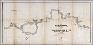
1851 No.5. Map of the Coatzacoalcos River fro … Separate Map 1851 Tehuantepec Survey, Major J.G. Barn … |

1851 No.6. Map of the River Uspanapa to the P … Separate Map Tehuantepec Survey, Maj. J.G. Barnard. U … |

1852 No.7. Chart of the ports of La Ventosa & … Separate Map Chart of the ports of La Ventosa & Salin … |

1852 No.8. Chart of the entrance and channel … Separate Map Chart of the entrance and channel of the … |

1775 The Western Coast of Louisiana and the C … Regional Atlas The Western Coast of Louisiana and the C … |

1775 The coast of Mexico from Laguna de Esmot … Regional Atlas The coast of Mexico from Laguna de Esmot … |

1775 The coast of Yucatan from Campeche to Ba … Regional Atlas The coast of Yucatan from Campeche to Ba … |

1775 The Coast of New Spain from Neuva (i.e., … Regional Atlas The Coast of New Spain from Neuva (i.e., … |

1797 St. Diego, St. Blas. [Chart Atlas, World Atlas] Plan du Port de St. Diego en Californie … |