Browse All

1825 Carta General Para Las Navegaciones a la … Chart Map Carta General Para Las Navegaciones a la … |

1825 Carta General Para Las Navegaciones a la … Chart Map Carta General Para Las Navegaciones a la … |

1825 Composite: Carta General Para Las Navega … Chart Map (Composite of) Carta General Para Las Na … |
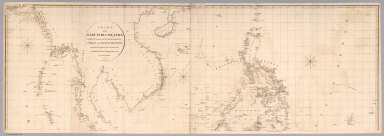
1812 Top sheet: Chart of the East India Islan … Chart Map (Top sheet of) Chart of the East India I … |

1812 Bottom sheet: Chart of the East India Is … Chart Map (Bottom sheet of) Chart of the East Indi … |

1812 Composite: Chart of the East India Islan … Chart Map (Composite of) Chart of the East India I … |

1764 Carte Des Isles Philippines Celebes et M … Chart Atlas Carte Des Isles Philippines Celebes et M … |

1764 Carte des Isles Philippines : Dressee su … Chart Atlas Carte des Isles Philippines : Dressee su … |

1764 Carte des Isles Philippines : Dressee su … Chart Atlas Carte des Isles Philippines : Dressee su … |

1764 Plan de la Baye de Manille Situee dans l … Chart Atlas Plan de la Baye de Manille situee dans l … |

1773 Admiralty I. views. Exploration Book Three views of the Admiralty Isles. (wit … |

1773 Dangerous shoal. Exploration Book A dangerous shoal seen Septr. the 28, 17 … |