Browse All

1803 Coast of Africa, from Cabo Verde to Cabo … Chart Atlas Coast of Africa, from Cabo Verde to Cabo … |

1803 Coast of Africa from Cabo Formosa to the … Chart Atlas Coast of Africa from Cabo Formosa to the … |

1803 Southern Coast of Africa. Chart Atlas Southern Coast of Africa drawn fro a Var … |

1777 S. extremity of America. Exploration Book A chart of the southern extremity of Ame … |

1777 S. Atlantic discoveries. Exploration Book Chart of the discoveries made in the Sou … |

1785 Kerguelen's Land. Exploration Book Kerguelen's Land called by C. Cook Islan … |

1785 Port Palliser, Christmas Harbour. Exploration Book Sketch of Port Palliser on Kerguelen's-L … |

1785 Arched Point, Kerguelen's Land. Exploration Book Three views of Arched Point on Kerguelen … |

1785 Van Diemen's Land. Exploration Book Chart of Van Diemen's Land. Harmar scrip … |

1785 Adventure Bay, Van Diemens Land. Exploration Book Plan of Adventure Bay in Van Diemens Lan … |

1785 Friendly Islands chart. Exploration Book Chart of the Friendly Islands. Writing b … |

1785 Tongataboo Harbour. Exploration Book Sketch of Tongataboo Harbour, 1777. The … |

1785 (Wanooaette, Wateeoo, Mangeea, Toobouai … Exploration Book (Plans of islands in the South Pacific. … |

1785 Eimeo harbours. Exploration Book Sketch of the harbours on the north side … |

1785 Christmas Island. Exploration Book Christmas Island. Latitude 1058' N. Long … |

1785 Views, W. coast America. Exploration Book Views on the west coast of America. (Lon … |

1785 Nootka Sound. Exploration Book Sketch of Nootka Sound ... 1778. The wri … |

1785 Cooks River. Exploration Book Chart of Cooks River in the N.W. part of … |

1785 Views, W. coast America. Exploration Book Views of the land on the west coast of A … |

1785 Samaganooda harbour, Oonalaska I. Exploration Book Sketch of the harbour of Samganooda on t … |

1785 Norton Sound, Bherings Strait. Exploration Book Chart of Norton Sound and of Bherings St … |

1785 Views on the coast of Asia. Exploration Book Views on the coast of Asia. J. Webber de … |

1785 Sandwich Islands. Exploration Book Sandwich Islands. (After missing views b … |

1785 Sandwich Islands. Exploration Book Chart of the Sandwich Islands. (with) Sk … |

1785 Awatska Bay. Exploration Book Plan of the Bay of Awatska on the east c … |

1785 Views coast Kamtschatka. Exploration Book Views on the coast of Kamtschatka. (Engr … |

1785 Part of Japan or Nipon. Exploration Book Part of Japan or Nipon. (with) View of t … |

1785 (Sulphur Island and vicinity) Exploration Book (Chart of Sulphur Island and vicinity). … |

1785 Typa, Macao. Exploration Book Sketch of the Typa and Macao. (Engraved … |

1785 General chart Cook voyages. Exploration Book A general chart: exhibiting the discover … |

1785 N.W. coast America, N.E. coast Asia. Exploration Book Chart of the N.W. coast of America and N … |

1885 Track Chart of the Cunard Line National Atlas Track Chart of the Cunard Line. Showing … |

1773 Cordes Bay, Port Famine, Woods Pay, Port … Exploration Book Cordes Bay and Harbour. (with) Port Fami … |

1773 Cape Providence, St. David's Cove, Islan … Exploration Book Cape Providence with the bay and anchori … |

1773 York Bay-Three Island Bay, Elizabeth Bay … Exploration Book From York Bay to Three Island Bay and Ha … |

1773 Hawkins's Maidenland, Falkland Sound. Exploration Book A chart of Hawkins's Maidenland, discove … |

1773 Saunders, Osnaburg, Boscawens, Keppels a … Exploration Book Sir Charles Saunders Island. (with) Osna … |

1773 Cocos, Traitors islands. Exploration Book (Cocos Island called by C. Wallis Boscaw … |
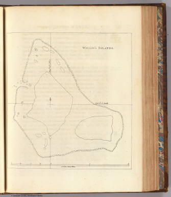
1773 Wallis's Islands. Exploration Book Wallis's Islands. (London: printed for W … |

1773 View Mas-a-fuera. Exploration Book A view of the N.W. side of Mas-a-fuera. … |

1773 Pitcairns Island. Exploration Book A chart and views of Pitcairns Island .. … |

1773 Queen Charlotte's Islands. Exploration Book Queen Charlotte's Islands. Bayly sculpt. … |

1773 Queen Charlotte's Islands. Exploration Book The north side of the largest of Queen C … |

1773 Nova Hibernia. Exploration Book Nova Hibernia. Publish'd Novr. 1st, 1772 … |
1773 New Britain discoveries. Exploration Book A chart of Captn. Carteret's discoveries … |

1773 Admiralty I. views. Exploration Book Three views of the Admiralty Isles. (wit … |

1773 Dangerous shoal. Exploration Book A dangerous shoal seen Septr. the 28, 17 … |

1773 Bonthain Bay. Exploration Book A draught of Bonthain Bay situated about … |

1773 Success Bay, Terra del Fuego. Exploration Book A plan of Success Bay in Strait le Maire … |

1773 Otaheite. Exploration Book Chart of the island Otaheite, by Lieut. … |