Who What Where WhenREMOVEWHERE
|
Author
[Cook, James, 1728-1779, Hawkesworth, John, 1715?-1773]
Full Title
Chart of the Society Isles, discovered by Lieut. J. Cook, 1769. J. Cheevers sculpsit. (London: printed for W. Strahan; and T. Cadell in the Strand, MDCCLXXIII).
Publisher
W. Strahan and T. Cadell
Author
[Cook, James, 1728-1779, Hawkesworth, John, 1715?-1773]
Full Title
Matavia (i.e. Matavai) Bay in Otaheite. Owharre Harbour in Huaheine. Ohamaneno Harbour in Ulietea. Oopoa Harbour in Ulietea. J. Cheevers sculp. (London: printed for W. Strahan; and T. Cadell in the Strand, MDCCLXXIII).
Publisher
W. Strahan and T. Cadell
Author
Hawkesworth, John, 1715?-1773
Full Title
A chart of the islands discover'd in the neighbourhood of Otaheite, in the course of several voyages round the world made by the cap(tai)ns Byron, Wallis, Carteret & Cooke in the years 1765, 1767, 1769. Whitchurch sculp., Pleasant Row, Islington. (London: printed for W. Strahan; and T. Cadell in the Strand, MDCCLXXIII).
Publisher
W. Strahan and T. Cadell
Author
[Cook, James, 1728-1779, Hawkesworth, John, 1715?-1773]
Full Title
Chart of New-Zealand, explored in 1769 and 1770 by Lieut. I: Cook, Commander of His Majesty's Bark Endeavour. Engrav'd by I. Bayly. Publish'd as the act directs 1st Jany. 1772. (London: printed for W. Strahan; and T. Cadell in the Strand, MDCCLXXIII).
Publisher
W. Strahan and T. Cadell
Author
[Cook, James, 1728-1779, Hawkesworth, John, 1715?-1773]
Full Title
River Thames and Mercury Bay in New Zealand. (with) Bay of Islands in New Zealand. (with) Tolaga Bay in New Zealand. (London: printed for W. Strahan; and T. Cadell in the Strand, MDCCLXXIII).
Publisher
W. Strahan and T. Cadell
Author
[Cook, James, 1728-1779, Hawkesworth, John, 1715?-1773]
Full Title
Chart of Cook's Strait in New Zealand. John Ryland sculp. (London: printed for W. Strahan; and T. Cadell in the Strand, MDCCLXXIII).
Publisher
W. Strahan and T. Cadell
Author
[Cook, James, 1728-1779, Hawkesworth, John, 1715?-1773]
Full Title
A chart of New South Wales, on the east coast of New-Holland. Discovered and explored by Lieutenant J: Cook, Commander of his Majesty's Bark Endeavour, in the year MDCCLXX. Engraved by W. Whitchurch, Bartholomew Lane, Royal Exchange. (London: printed for W. Strahan; and T. Cadell in the Strand, MDCCLXXIII).
Publisher
W. Strahan and T. Cadell
Author
[Cook, James, 1728-1779, Hawkesworth, John, 1715?-1773]
Full Title
Entrance of Endeavour River in New South Wales. Botany Bay in New South Wales. J. Gibson & T. Bowen sculp. (London: printed for W. Strahan; and T. Cadell in the Strand, MDCCLXXIII).
Publisher
W. Strahan and T. Cadell
Author
[Cook, James, 1728-1779, Hawkesworth, John, 1715?-1773]
Full Title
Chart of part of the coast of New South Wales, from Cape Tribulation to Endeavour Straits, by Lieut. J. Cook, 1770. J. Cheevers sculpt. (London: printed for W. Strahan; and T. Cadell in the Strand, MDCCLXXIII).
Publisher
W. Strahan and T. Cadell
Author
Cook, James, 1728-1779
Full Title
A chart of the Southern Hemisphere; shewing the tracks of some of the most distinguished navigators: by Captain James Cook of his Majesty's Navy. Gulielmus Whitchurch, sculpsit; Anno. 1776. Published Febry. 1st., 1777 by Wm. Strahan in New Street, Shoe Lane & Thos. Cadell in the Strand, London.
Publisher
W. Strahan and T. Cadell
Author
Cook, James, 1728-1779
Full Title
Port Praya in the island St. Jago, one of the Cape de Verds. Published Feby. 1st., 1777 by Wm. Strahan in New Street, Shoe Lane & Thos. Cadell in the Strand, London. No. X.
Publisher
W. Strahan and T. Cadell
Author
Cook, James, 1728-1779
Full Title
Sketch of Dusky Bay in New Zeeland; 1773. (with) Pickersgill Harbour. W. Whitchurch sculpsit, Islington, 1776. No. XIII. Published Febry. 1st., 1777 by Wm. Strahan in New Street, Shoe Lane & Thos. Cadell in the Strand, London.
Publisher
W. Strahan and T. Cadell
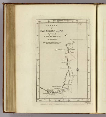
Author
Furneaux, Tobias, 1735-1781
Full Title
Sketch of Van Diemen Land, explored by Captn. Furneaux, in March 1773. J Russell sculpt. No. VIII. Published Febry. 1st., 1777, by Wm. Strahan in New Street, Shoe Lane & Thos. Cadell in the Strand, London.
Publisher
W. Strahan and T. Cadell
Author
Cook, James, 1728-1779
Full Title
Chart of the Friendly Isles. No. XIV. Published Febry. 1st, 1777 by Wm. Strahan in New Street, Shoe Lane & Thos. Cadell in the Strand, London.
Publisher
W. Strahan and T. Cadell
Author
Cook, James, 1728-1779
Full Title
Easter Island. W. Whitchurch sculpt., 1776. Published Febry. 1st, 1777 by Wm. Strahan in New Street, Shoe Lane & Thos. Cadell in the Strand, London. No. IX.
Publisher
W. Strahan and T. Cadell
Author
Cook, James, 1728-1779
Full Title
Sketch of the Marquesas de Mendoca. (with) Resolution Bay or Port Madre de Dios. J. Russell sculpsit. No. V. Published Febry. 1st, 1777 by Wm. Strahan in New Street, Shoe Lane & Thos. Cadell in the Strand, London.
Publisher
W. Strahan and T. Cadell
Author
Cook, James, 1728-1779
Full Title
Harvey's Isle. Palmerston Isle. Turtle Isle. Savage Isle. No. XII. Published Febry. 1st, 1777 by Wm. Strahan in New Street, Shoe Lane & Thos. Cadell in the Strand, London.
Publisher
W. Strahan and T. Cadell
Author
Cook, James, 1728-1779
Full Title
Chart of discoveries made in the South Pacific Ocean in his majesty's ship Resolution under the command of Captain Cook, 1774. Published as the act directs Feby. 1st, 1776. Engraved by W. Palmer. Published Febry. 1st, 1777 by Wm. Strahan in New Street, Shoe Lane & Thos. Cadell in the Strand, London.
Publisher
W. Strahan and T. Cadell
Author
Cook, James, 1728-1779
Full Title
Port Resolution in the Isle of Tanna. (with) Port Sandwich in Mallicollo. (with) Harbour of Balade in New Caledonia. No. XI. Published Febry. 1st, 1772 by Wm. Strahan in New Street, Shoe Lane & Thos. Cadell in the Strand, London.
Publisher
W. Strahan and T. Cadell
Author
Cook, James, 1728-1779
Full Title
Norfolk Isle. No. VI. Published Febry. 1st, 1777 by Wm. Strahan in New Street, Shoe Lane & Thos. Cadell in the Strand, London.
Publisher
W. Strahan and T. Cadell
Author
Cook, James, 1728-1779
Full Title
Christmas Sound on the S.W. coast of Terra (sic) del Fuego. No. VII. Published Febry. 1st, 1777 by Wm. Strahan in New Street, Shoe Lane & Thos. Cadell in the Strand, London.
Publisher
W. Strahan and T. Cadell
Author
Ringgold, Cadwalader.
Full Title
General Chart, Embracing Surveys of the Bays of San Francisco and San Pablo, Straits of Carquines and Suisun Bay, and the Sacramento and San Joaquin Rivers to the Cities of Sacramento and San Joaquin, California, by Cadwalader Ringgold, Commmander, U.S. Navy, 1850. Constructed, Projected and Drawn by Fred D. Stuart, Hydrographer, late of the U.S. Ex Ex, Assisted by Chas Everett Jr., Draughtman. Executed at the request of the undersigned citizens of California ... and Inscribed to William H. Aspiwall Esq., City of New Your.
Publisher
Jno. T. Towers
Author
Cram, George Franklin
Full Title
Chart of the World in Mercator's Projection.
Publisher
A.C. Shewey and Co.
Author
Bradford, Thomas G.
Full Title
Comparative chart, of Continents, Oceans, Islands &c. (to accompany) A Comprehensive Atlas, Geographical, Historical & Commercial. By T.G. Bradford. William D. Ticknor, Boston. Wiley & Long, New-York. Entered ... 1835, by Thos. G. Bradford ... Massachusetts.
Publisher
[William D. Ticknor, Wiley & Long]
Author
Bowen, Emanuel
Full Title
Particular draughts and plans of some of the principal towns and harbours belonging to the English, French, and Spaniards, in America and West Indies. Collected from the best authorities, by Eman. Bowen. (London: Printed for William Innys, Richard Ware, Aaron Ward, J. and P. Knapton, John Clarke, T. Longman and T. Shewell, Thomas Osborne, Henry Whitridge ... M.DCC.XLVII)
Publisher
William Innys [et al.]
Author
United States Coast Survey
Full Title
(Covers to) Map of New - York Bay And Harbor And The Environs. Founded upon a Trigonometrical Survey under the direction of F.R. Hassler Superintendent of the Survey Of The Coast Of The United States. Triangulation by James Ferguson and Edmund Blunt Assistants. The Hydrography under the direction of Thomas R. Gedney Lieutenant U.S. Navy. The Topography by C. Renard, T.A. Jenkins & B.F. Sands Assists. Published in 1845. A.D. Bache Superintendent. Verified by Lieut. A.A. Humphreys ... Topography Engraved by S. Siebert & A. Rolle, Views Engraved by O.A. Lawson. Engraving supervised & Views of the Coast drawn by J. Farley. Hydrography Engraved by F. Dankworth, Lettering by F. Dankworth & J. Knight.
Publisher
U.S.
Author
La Perouse, Jean-Francois de Galaup, comte de, 1741-1788
Full Title
Plan de l'Isle de Paque. Leve en Avril 1786 a bord des Frigates Francaises la Boussole et l'Astrolabe. Plan de la Baie de Cook, situee a la Cote Occidle. de l'Ile de Paque ... Barriere (scripsit?). Atlas du Voyage de la Perouse no. 10. (Paris: L'Imprimerie de la Republique, An V, 1797)
Publisher
L'Imprimerie de la Republique
Author
La Perouse, Jean-Francois de Galaup, comte de, 1741-1788
Full Title
Carte des cotes de l'Amerique et de l'Asie depuis la Californie jusqu'a Macao, d'apres les decouvertes faites en 1786 et 1787 par les Fregates Francaises la Boussole et l'Astrolabe. P.F. Tardieu sculp. Atlas du Voyage de la Perouse no. 15. (Paris: L'Imprimerie de la Republique, An V, 1797)
Publisher
L'Imprimerie de la Republique
Author
[Dagelet, Joseph Lepaute, La Perouse, Jean-Francois de Galaup, comte de, 1741-1788]
Full Title
Carte generale d'une partie de la cote du nord-ouest de l'Amerique reconnue par les Fregates Francaises la Boussole et l'Astrolabe. Assujettie au point journalier de la Fregate la Boussole determine astronomiquement par M. Dagelet. Bouclet sculp. Herault scrip. Atlas du Voyage de la Perouse no. 16. (Paris: L'Imprimerie de la Republique, An V, 1797)
Publisher
L'Imprimerie de la Republique
Author
La Perouse, Jean-Francois de Galaup, comte de, 1741-1788
Full Title
Carte particuliere de la cote du nord-ouest de l'Amerique reconnue par les Fregates Francaises la Boussole et l'Astrolabe en 1786. 1e. feuille. Bouclet sculp. Herault scrip. Atlas du Voyage de la Perouse no. 17. (Paris: L'Imprimerie de la Republique, An V, 1797)
Publisher
L'Imprimerie de la Republique
Author
La Perouse, Jean-Francois de Galaup, comte de, 1741-1788
Full Title
Plan du Port des Francais sur la cote du nord-ouest de l'Amerique, par 58037' de latitude nord et 139050' de longitude occidentale decouvert le 2 Juillet 1786 par les Fregates Francaise la Boussole et l'Astrolabe. Atlas du Voyage de la Perouse. Bouclet sculp. Herault scrip. (Paris: L'Imprimerie de la Republique, An V, 1797)
Publisher
L'Imprimerie de la Republique
Author
[La Perouse, Jean-Francois de Galaup, comte de, 1741-1788, Mourelle de la Rua, Francisco Antonio, 1750-1820]
Full Title
Plan de l'entree du Port de Bucarelli sur la cote du nord-ouest de l'Amerique, par 55015' de latitude nord et 136015' de longitude a l'ouest de Paris. Decouverte en 1775, sur la Goelette Espagnole la Sonora, par D. Juan Fco. de la Quadra et D. Franco. Anto. Maurelle; et reconnue plus amplement dans l'Expedition de 1779, par les memes officiers et autres de la Marine d'Espagne. Grave par Bouclet. Ecrit par Herault. Atlas du Voyage de la Perouse no. 26. (Paris: L'Imprimerie de la Republique, An V, 1797)
Publisher
L'Imprimerie de la Republique
Author
La Perouse, Jean-Francois de Galaup, comte de, 1741-1788
Full Title
Carte particuliere de la cote du nord-ouest de l'Amerique reconnue par les Fregates Francaises la Boussole et l'Astrolabe en 1786. 2e. feuille. Bouclet sculp. Herault scrip. Atlas du Voyage de la Perouse no. 29. (Paris: L'Imprimerie de la Republique, An V, 1797)
Publisher
L'Imprimerie de la Republique
Author
La Perouse, Jean-Francois de Galaup, comte de, 1741-1788
Full Title
Carte particuliere de la cote du nord-ouest de l'Amerique reconnue par les Fregates Francaises la Boussole et l'Astrolabe en 1786. 3e. feuille. Bouclet sculp. Herault scrip. Atlas du Voyage de la Perouse no. 31. (Paris: L'Imprimerie de la Republique, An V, 1797)
Publisher
L'Imprimerie de la Republique
Author
[Bernizet, Sebastien, La Perouse, Jean-Francois de Galaup, comte de, 1741-1788]
Full Title
Carte plate de l'Ile Necker situee par 23034' de latitude N, et 166052' de longitude a l'ouest de Paris et de la Basse des Fregates Francaises situee par 23045' de latitude N. et 168010' de longitude, decouvertes en Novembre 1786. Ecrit par Herault. Atlas du Voyage de la Perouse no. 38. (Paris: L'Imprimerie de la Republique, An V, 1797)
Publisher
L'Imprimerie de la Republique
Author
La Perouse, Jean-Francois de Galaup, comte de, 1741-1788
Full Title
Carte generale des decouvertes, faites en 1787 dans les mers de Chine et de Tartarie ou depuis Manille jusqu'a Avatscha, par les Fregates Francaises la Boussole et l'Astrolabe. Atlas du Voyage de la Perouse no. 39. (Paris: L'Imprimerie de la Republique, An V, 1797)
Publisher
L'Imprimerie de la Republique
Author
La Perouse, Jean-Francois de Galaup, comte de, 1741-1788
Full Title
Carte des decouvertes, faites en 1787 dans les mers de Chine et de Tartarie, par les Fregates Francaises la Boussole et l'Astrolabe, depuis leur depart de Manille jusqu'a leur arrivee au Kamtschatka. 2e. feuille. Atlas du Voyage de la Perouse no. 46. (Paris: L'Imprimerie de la Republique, An V, 1797)
Publisher
L'Imprimerie de la Republique
Author
[La Perouse, Jean-Francois de Galaup, comte de, 1741-1788, Vries, Maarten Gerritszoon]
Full Title
Carte des decouvertes au nord du Japon. Faites en 1643 par les Vaisseaux Hollandais le Kastrikum et le Breskens, comprenant la Terre de Jeso, l'Ile des Etats et la Terre de la Compagnie, dont partie a ete reconnue en 1787 par les Fregates Francaises la Boussole et l'Astrolabe. Ecrit par Herault. (with) Vue de la Terre de la Compagnie. Atlas du Voyage de la Perouse no. 47. (Paris: L'Imprimerie de la Republique, An V, 1797)
Publisher
L'Imprimerie de la Republique
Author
La Perouse, Jean-Francois de Galaup, comte de, 1741-1788
Full Title
Plan de la Baie de Ternai. Situee sur la cote de Tartarie par 45013'00" de latitude nord et par 135009'00" de longitude orientale. Cette Baie fut decouverte le 22. Juin 1787, par les Fregates Francaises la Boussole et l'Astrolabe. L. Aubert scripsit. Atlas du Voyage de la Perouse no. 48. (Paris: L'Imprimerie de la Republique, An V, 1797)
Publisher
L'Imprimerie de la Republique
Author
La Perouse, Jean-Francois de Galaup, comte de, 1741-1788
Full Title
Plan de la Baie de Langle. Situee a la partie ouest de l'Ile de Tchoka par 47048'36" de latitude nord et 139057'54" de longitude orientale. L. Aubert scripsit. Atlas du Voyage de la Perouse no. 49. (Paris: L'Imprimerie de la Republique, An V, 1797)
Publisher
L'Imprimerie de la Republique
Author
La Perouse, Jean-Francois de Galaup, comte de, 1741-1788
Full Title
Plan de la Baie d'Estaing. Situee a la cote de l'ouest de Tchoka par 48059'38" de latitude nord, et par 14000'42" de longitude orientale, prise du mouillage de l'Astrolabe. Cette Baie fut decouverte le 20 juillet 1787 par les Fregates Francaises la Boussole et l'Astrolabe commandees par MM. de La Perouse et de Langle. L. Aubert scripsit. Atlas du Voyage de la Perouse no. 51. (Paris: L'Imprimerie de la Republique, An V, 1797)
Publisher
L'Imprimerie de la Republique
Author
[Bernizet, Sebastien, La Perouse, Jean-Francois de Galaup, comte de, 1741-1788]
Full Title
Plan de la Baie Castries. Situee sur la cote orientale de Tartarie, par 51029'0" de latitude nord et 139039'0" de longitude orientale du meridien de Paris, leve en juillet 1787. Par Sen. Bernizet sous l'inspection de M. de la Perouse. L. Aubert scripsit. Atlas du Voyage de la Perouse no. 52. (Paris: L'Imprimerie de la Republique, An V, 1797)
Publisher
L'Imprimerie de la Republique
Author
[Bougainville, Louis-Antoine de, comte, 1729-1811, La Perouse, Jean-Francois de Galaup, comte de, 1741-1788]
Full Title
Carte de l'Archipel des Navigateurs, decouvert par M. de Bougainville en Mai 1768, et reconnu par les Fregates Francaises la Boussole et l'Astrolabe en Decembre 1787. Ecrit par Herault. Atlas du Voyage de la Perouse no. 64. (Paris: L'Imprimerie de la Republique, An V, 1797)
Publisher
L'Imprimerie de la Republique
Author
La Perouse, Jean-Francois de Galaup, comte de, 1741-1788
Full Title
Plan d'une partie de l'Ile de Maouna, vue par les Fregates Francaises la Boussole et l'Astrolabe en Decembre 1787 ... Plan de l'Anse du Massacre, situee a la partie nord-ouest de Maouna, l'une des Iles des Navigateurs. Position des chaloupes et canots des Fregates Francaises au moment du Massacre du 11. Decembre 1787. L. Aubert script. Atlas du Voyage de la Perouse no. 65. (Paris: L'Imprimerie de la Republique, An V, 1797)
Publisher
L'Imprimerie de la Republique
Author
La Perouse, Jean-Francois de Galaup, comte de, 1741-1788
Full Title
Partie de la Mer du Sud comprise entre les Philippines et la Californie d'apres de Carte Espagnole trouvee sur le Galion pris par l'Amiral Anson en 1743, qui represente l'etat des connaissances a cette epoque, et les routes que suivaient ordinairement les Galions dans leur traversee de Manille a Acapulco. Partie de la Mer du Sud comprise entre les Philippines et la California d'apres une autre Carte Espagnole communiquee a La Perouse dans sa relache a Monterey, sur laquelle il avait trace sa route ainsi que les Iles qu'il avait reconnues, avec des notes sur celles qu'il n'avait pas retrouvee. Atlas du Voyage de la Perouse no. 65. (Paris: L'Imprimerie de la Republique, An V, 1797)
Publisher
L'Imprimerie de la Republique
Author
[La Perouse, Jean-Francois de Galaup, comte de, 1741-1788, Mourelle de la Rua, Francisco Antonio, 1750-1820]
Full Title
Carte d'une partie du Grand Ocean a l'E. et SE. de la Nouvelle Guinee pour l'intelligence du voyage de la Fregate Espagnole la Princesa commandee par D. Franco. Antonio Maurelle en 1781. Atlas du Voyage de la Perouse no. 68. (Paris: L'Imprimerie de la Republique, An V, 1797)
Publisher
L'Imprimerie de la Republique
Author
La Perouse, Jean-Francois de Galaup, comte de, 1741-1788
Full Title
Plan des Iles Kuriles et des terres peu connues situees a la suite de ces Iles: d'apres au manuscrit conserve dans les Archives d'Ochotsk qui a ete communique a M. Lesseps, en 1788. (with) Partie peu connue des Is. Aleutiennes ... Grave par Bouclet. Ecrit par Herault. Atlas du Voyage de la Perouse no. 69. (Paris: L'Imprimerie de la Republique, An V, 1797)
Publisher
L'Imprimerie de la Republique
Author
La Perouse, Jean-Francois de Galaup, comte de, 1741-1788
Full Title
Carte des decouvertes, faites en 1787 dans les mers de Chine et de Tartarie, par les Fregates Francaises la Boussole et l'Astrolabe, depuis leur depart de Manille jusqu'a leur arrivee au Kamtschatka. 1ere. feuille. Gravee par Bouclet. Ecrit par Herault. Atlas du Voyage de la Perouse no. 43. (Paris: L'Imprimerie de la Republique, An V, 1797)
Publisher
L'Imprimerie de la Republique
Author
La Perouse, Jean-Francois de Galaup, comte de, 1741-1788
Full Title
Plan de la partie des iles, ou archipel de Coree, vue au mois de Mai 1787 par les Fregates Francaises la Boussole et l'Astrolabe. Gravee par Bouclet. Ecrit par Herault. Atlas du Voyage de la Perouse no. 44. (Paris: L'Imprimerie de la Republique, An V, 1797)
Publisher
L'Imprimerie de la Republique
Author
La Perouse, Jean-Francois de Galaup, comte de, 1741-1788
Full Title
Plan de la partie de l'Ile de Quelpaert vue le 21. May 1787 par les Fregates Francaises la boussole et l'Astrolabe ... Plan de l'Ile Hoapinsu et des ilots qui l'environnent ... Plan de l'Ile Dagelet ... Plan de la partie de l'Ile de Botol ... Plan de l'Ile de Kumi ... L. Aubert scripsit. Atlas du Voyage de la Perouse no. 44. (Paris: L'Imprimerie de la Republique, An V, 1797)
Publisher
L'Imprimerie de la Republique
|