Browse All

1764 Carte De La Riviere De Gambra ou Gambie … Chart Atlas Carte De La Riviere De Gambra ou Gambie … |

1764 Carte Du Cours De La Riviere De Gambra o … Chart Atlas Carte Du Cours De La Riviere De Gambra o … |

1764 Carte De L'Entrée De La Riviere De Sier … Chart Atlas Carte De L'Entrée De La Riviere De Sier … |

1764 Entree De La Riviere De Sestos Chart Atlas Entree De La Riviere De Sestos. (engrave … |

1764 Partie de la Coste de Guinee depuis la R … Chart Atlas Partie de la Coste de Guinee depuis la R … |

1764 Coste De Guinee : Depuis le Cap Apolloni … Chart Atlas Coste De Guinee : Depuis le Cap Apolloni … |

1764 Carte Du Golfe De Benin Et Partie De La … Chart Atlas Carte Du Golfe De Benin Et Partie De La … |

1764 Carte De La Riviere de Kalbar, Appellee … Chart Atlas Carte De La Riviere de Kalbar, Appellee … |

1764 Carte des Royaumes de Congo, Angola et B … Chart Atlas Carte des Royaumes de Congo, Angola et B … |

1764 Rade De Benguela Et Riviere De Cantonbel … Chart Atlas Rade De Benguela Et Riviere De Cantonbel … |

1764 Carte Du Pais Des Hottentots : aux Envir … Chart Atlas Carte Du Pais Des Hottentots : aux Envir … |

1764 Baye De Saldane : au Nord-Ouest du Cap d … Chart Atlas Baye De Saldane : au Nord-Ouest du Cap d … |

1764 Carte De La Baye De La Table, Et Rade Du … Chart Atlas Carte De La Baye De La Table, Et Rade Du … |

1764 Plan du Fort et de la Ville du Cap de Bo … Chart Atlas Plan du Fort et de la Ville du Cap de Bo … |

1764 Carte de L'Isle de Madagascar et du Cana … Chart Atlas Carte de L'Isle de Madagascar et du Cana … |

1764 Carte de L'Ance Dauphine dans l'Isle de … Chart Atlas Carte de L'Ance Dauphine dans l'Isle de … |

1764 Carte de la Baye d'Antongil dans l'Isle … Chart Atlas Carte de la Baye d'Antongil dans l'Isle … |

1764 Carte de la Baye de Mosambique Chart Atlas Carte de la Baye de Mosambique. |

1764 Carte de L'Isle de France Chart Atlas Carte de L'Isle de France. |

1764 Plan du Port Bourbon en l'Isle de France Chart Atlas Plan du Port Bourbon en l'Isle de France … |

1764 Plan du Port Louis dans l'Isle de France Chart Atlas Plan du Port Louis dans l'Isle de France … |

1764 Carte de l'Isle de Bourbon autrefois Mas … Chart Atlas Carte de l'Isle de Bourbon autrefois Mas … |

1764 Plan de l'Isle Ste Helene Chart Atlas Plan de l'Isle Ste Helene. |

1798 The Coast of N.W. America. Chart Atlas A Chart shewing part of the Coast of N.W … |

1798 The Coast of N.W. America. Chart Atlas A Chart shewing part of the Coast of N.W … |

1798 The Coast of N.W. America. Chart Atlas A Chart shewing part of the Coast of N.W … |

1798 The Coast of N.W. America. Chart Atlas A Chart Shewing part of the Coast of N.W … |

1798 The Coast of N.W. America. Chart Atlas A Chart Shewing part of the Coast of N.W … |

1798 The Coast of N.W. America. Chart Atlas A Chart Shewing part of the Coast of N.W … |

1798 Views of the Sandwich and other Islands. Chart Atlas Views of the Sandwich and other Islands. … |
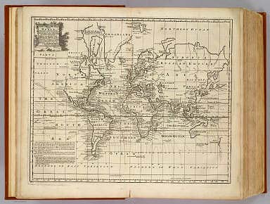
1747 Chart of the World. Geography Book A new & accurate chart of the world. Dra … |

1828 The north eastern coast, North America, … Chart Atlas (The north eastern coast of North Americ … |

1828 The north eastern coast, North America, … Chart Atlas The north eastern coast of North America … |

1828 The north eastern coast, North America, … Chart Atlas (The north eastern coast of North Americ … |

1827 The harbour of New York, Entrance to Che … Chart Atlas The harbour of New York surveyed by Edmu … |

1827 The coast of the United States from New … Chart Atlas The coast of the United States of North … |

1827 The coast of the United States from New … Chart Atlas (The coast of the United States of North … |

1827 The coast of the United States from New … Chart Atlas (The coast of the United States of North … |

1827 (The Bahama Banks and Gulf of Florida. E … Chart Atlas (The Bahama Banks and Gulf of Florida by … |

1827 The Bahama Banks and Gulf of Florida (We … Chart Atlas The Bahama Banks and Gulf of Florida by … |

1827 Composite: Bahama Banks, Gulf of Florida … Chart Atlas (Composite of) The Bahama Banks and Gulf … |

1828 The coasts of West Florida, Alabama, Mis … Chart Atlas The coasts of West Florida, Alabama, Mis … |

1747 Seven United Provinces. Geography Book A new and accurate map of the Seven Unit … |

1747 N. parts of Italy. Geography Book A new and accurate map of the northern p … |

1848 No.3. Mouth of the Coatzacoalcos River s … Separate Map Mouth of the Coatzacoalcos River surveye … |

1847 No.4. Sketch from the mouth of the Coatz … Separate Map Sketch from the mouth of the Coatzacoalc … |
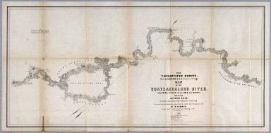
1851 No.5. Map of the Coatzacoalcos River fro … Separate Map 1851 Tehuantepec Survey, Major J.G. Barn … |

1851 No.6. Map of the River Uspanapa to the P … Separate Map Tehuantepec Survey, Maj. J.G. Barnard. U … |

1852 No.7. Chart of the ports of La Ventosa & … Separate Map Chart of the ports of La Ventosa & Salin … |

1852 No.8. Chart of the entrance and channel … Separate Map Chart of the entrance and channel of the … |