Who What Where WhenREMOVE |
Full Title
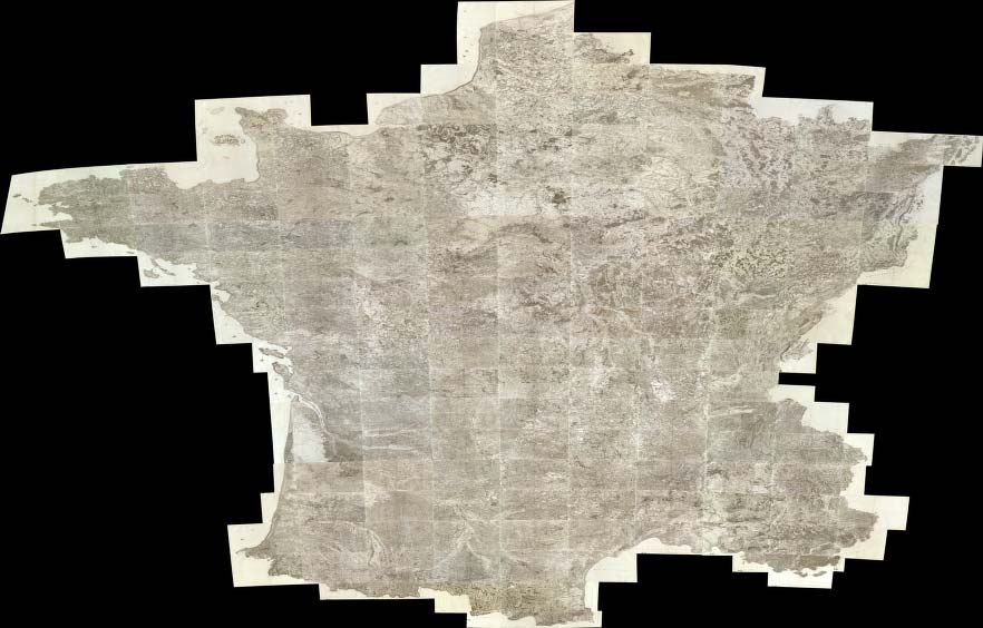
(Composite of) (Carte de France. 9). No. 8 (Orleans). No. 9 (Gien). No. 10 (Bourges). No. 11 (La Chatre). No. 28 (Vendome). No. 29 (Blois). No. 30 (Loches). No. 31 (Le Blanc - Chateauroux - Montmorillon). No. 47 (Auxerre). No. 48 (Vezelay - Cosne). No. 49 (Nevers). No. 50 (Moulins). No. 82 (Tonnerre). No. 83 (Semur - Montbard). No. 84 (Autun). No. 85 (Chalon-sur-Saone. Levee par ordre du Roy. 1750-1815)
Publisher
Carte de la France Directeures
Full Title
(Composite of) (Carte de France. 10). No. 113 (Langres). No. 114 (Dijon). No. 115 (Dole - Auxonne). No. 116 (Tournus - Lons-le-Saunier). No. 144 (Luxeuil). No. 145 (Vesoul). No. 146 (Besancon). No. 147 (Nozeroy - Les Rousses). No. 164 (Neuf-Brisach). No. 165 (Bale. Levee par ordre du Roy. 1750-1815)
Publisher
Carte de la France Directeures
Author
[Canada. Department of Interior, Chalifour, J.E.]
Full Title
(Composite map of) Physical map of the Dominion of Canada. Physical. Atlas of Canada. (to accompany) Department of the Interior Canada. Atlas Of Canada, 1915.
Publisher
Department of Interior
Author
[Canada. Department of Interior, Chalifour, J.E.]
Full Title
(Composite map of) Geological map of the Dominion of Canada. Geology supplied by the Geological Survey. Atlas of Canada. (to accompany) Department of the Interior Canada. Atlas Of Canada, 1915.
Publisher
Department of Interior
Author
[Canada. Department of Interior, Chalifour, J.E.]
Full Title
(Composite map of) Mineral map of Dominion of Canada. Information from the Department of Mines. Minerals. Atlas of Canada. (to accompany) Department of the Interior Canada. Atlas Of Canada, 1915.
Publisher
Department of Interior
Full Title
(Composite of) Carte de France. Levee par ordre du Roy. (1750-1815)
Publisher
Carte de la France Directeures
Author
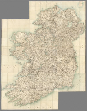
Ireland. Ordnance Survey.
Full Title
(Composite) Sheets 1-16.
Publisher
Ordnance Survey of Ireland
Author
[Woerl, Joseph Edmund, Herder, Bartholomew]
Full Title
(Composite of) Sheets 1 - 20 of Karte der Schweiz, von Dr. I. Woerl. Lithographie von B. Herder in Freiburg im Breisgau.
Publisher
B. Herder
Author
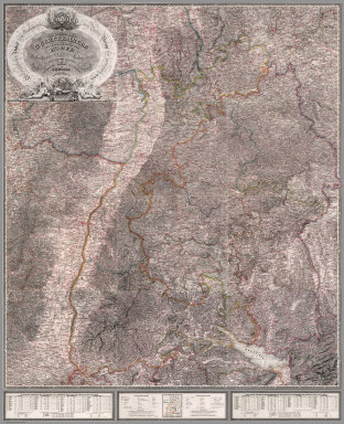
[Woerl, Joseph Edmund, Herder, Benjamin]
Full Title
(Composite of) Sheets 1 - 12 Das Koenigreich Wuerttemberg Das Grossherzogthum Baden und die Fuurstenthuumer Hohenzollern : entworfen und bearbeitet im Maasstabe 1:200 000 in 12 Blaettern von I.E. Woerl.
Publisher
Herder'sche Kunst- u. Buchhandlung
Author
[Conder, C.R. (Claude Reignier), Kitchener, H.R. (Horatio Herbert)]
Full Title
(Composite). Map of Western Palestine from Surveys Conducted for The Committee of the Palestine Exploration Fund ... Reduced from the One-Inch Map ... Special Edition Illustrating the Divisions of the Natural Drainage and the Mountain Ranges According to "An Introduction to the Survey of Western Palestine by Trelawney Saunders.
Publisher
Committee of the Palestine Exploration Fund
Author
[Conder, C.R. (Claude Reignier), Kitchener, H.R. (Horatio Herbert)]
Full Title
(Composite of) Map of Western Palestine in 26 Sheets from Surveys Conducted for The Committee of the Palestine Exploration Fund by Lieutenants C.R. Cronder and H.H. Kitchener, R.E. (Royal Engineers) during the years 1872-1877. Scale: One Inch to a Mile=1/63,360. Photozincographed for the Committee under the Superintendence of Lt. Coll. Carey, R.E. at the Ordnance Survey Office, Southampton, Colonel Cooke, C.B., R.E., Director, by Permission of the First Commissioner of H.M. Works. London. 1880.
Publisher
Committee of the Palestine Exploration Fund
Author
[Conder, C.R. (Claude Reignier), Kitchener, H.R. (Horatio Herbert)]
Full Title
(Composite). Map of Western Palestine from Surveys Conducted for The Committee of the Palestine Exploration Fund ... Special Edition Illustrating The Old Testament, The Apocrypha and Josephus ... by Trelawney Saunders. Scale 3/8 inch to one mile of 1:168,960.
Publisher
Committee of the Palestine Exploration Fund
Author
[Conder, C.R. (Claude Reignier), Kitchener, H.R. (Horatio Herbert)]
Full Title
(Composite). Map of Western Palestine from Surveys Conducted for The Committee of the Palestine Exploration Fund ... Special Edition Illustrating The New Testament, also The Talmud and Josephus ... by Trelawney Saunders. Scale 3/8 inch to one mile of 1:168,960.
Publisher
Committee of the Palestine Exploration Fund
Author
[Conder, C.R. (Claude Reignier), Kitchener, H.R. (Horatio Herbert)]
Full Title
(Composite). Map of Western Palestine from Surveys Conducted for The Committee of the Palestine Exploration Fund ... Reduced from the One-Inch Map. Scale 3/8 inch to one mile or 1:168,960.
Publisher
Committee of the Palestine Exploration Fund
Full Title
(Composite of) (Carte de France. 11). No. 68 (Charroux). No. 69 (Angouleme). No. 70 (Perigueux). No. 71 (Bergerac). No. 101 (La Rochelle). No. 102 (Saintes). No. 103 (Blaye). No. 104 (Bordeaux). No. 133 (Ile de Re). No. 134 (Ile d'Oleron). No. 135 (Cote de Medoc). No. 136 (La Teste de Buch. Levee par ordre du Roy. 1750-1815)
Publisher
Carte de la France Directeures
Full Title
(Composite of) (Carte de France. 12). No. 12 (Evaux). No. 13 (Aubusson). No. 14 (Mauriac). No. 15 (Aurillac). No. 32 (Le Dorat). No. 33 (Limoges). No. 34 (Tulle - Pompadour). No. 35 (Sarlat). No. 51 (Gannat - Saint-Pourcain). No. 52 (Clermont). No. 53 (Brioude - Issoire). No. 54 (Saint-Flour). No. 86 (Macon). No. 87 (Lyon). No. 88 (Saint-Etienne - Saint-Marcellin). No. 89 (Le Puy. Levee par ordre du Roy. 1750-1815)
Publisher
Carte de la France Directeures
Full Title
(Composite of) (Carte de France. 13). No. 117 (Bourg-en-Bresse). No. 118 (Belley). No. 119 (Grenoble). No. 120 (Valence). No. 148 (Geneve - Gex). No. 149 (Montmelian). No. 150 (Fort Barraux). No. 151 (Briancon). No. 166 (Queyras . Levee par ordre du Roy. 1750-1815)
Publisher
Carte de la France Directeures
Full Title
(Composite of) (Carte de France. 14). No. 72 (Castillonez - Villeneuve - La Reole). No. 73 (Agen). No. 74 (Auch). No. 75 (Tarbes). No. 105 (Bazas). No. 106 (Roquefort - Mont-de-Marsan). No. 107 (Aire - Orthez). No. 108 (Pau - Bearn). No. 137 (Cazau). No. 138 (Vieux-Boucau). No. 139 (Bayonne). No. 140 (Saint-Jean-Pied-de-Port. Levee par ordre du Roy. 1750-1815)
Publisher
Carte de la France Directeures
Full Title
(Composite of) (Carte de France. 15). No. 16 (Rodez). No. 17 (Albi). No. 18 (Castres). No. 19 (Carcassonne). No. 36 (Cahors). No. 37 (Montauban). No. 38 (Toulouse). No. 39 (Saint-Lizier - Saint-Martory - Pamiers). No. 55 (Mende). No. 56 (Nant - Millaud). No. 57 (Lodeve). No. 58 (Narbonne). No. 90 (Viviers). No. 91 (Nimes). No. 92 (Montpellier. Levee par ordre du Roy. 1750-1815)
Publisher
Carte de la France Directeures
Full Title
(Composite of) (Carte de France. 16). No. 121 (Vaison). No. 122 (Avignon - Orange). No. 123 (Aix). No. 124 (Marseille). No. 152 (Embrun). No. 153 (Digne). No. 154 (Lorgues). No. 155 (Toulon). No. 167 (Larche). No. 168 (Vence). No. 169 (Antibes). No. 182 (169+ Tour de Camarat. Levee par ordre du Roy. 1750-1815)
Publisher
Carte de la France Directeures
Full Title
(Composite of) (Carte de France. 17). No. 76 (Luchon - Bareges - Bagneres). No. 108+ (Cauterets. Levee par ordre du Roy. 1750-1815)
Publisher
Carte de la France Directeures
Full Title
(Composite of) (Carte de France. 18). No. 20 (Montlouis - Mousset - Moussette). No. 20+ (Puigcerda - Prats de Mollo - Fort des Bains). No. 40 (Ax). No. 40+ (Andorre). No. 59 (Perpignan). No. 59+ (Bellegarde. Levee par ordre du Roy. 1750-1815)
Publisher
Carte de la France Directeures
Author
[Collot, George Henri Victor, Tardieu, P.F.]
Full Title
(Composite of) A General Map Of The River Ohio, From its source to its mounth (sic): containing the names of the Towns Villages and Farms established at present on its banks: together with its soundings, and courses. (Plates one through four.) Grave par Tardieu l'aine. PL. 8-11.
Publisher
Arthus Bertrand
Author
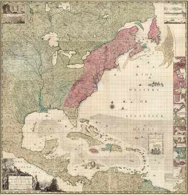
Popple, Henry
Full Title
(Composite Map of) A Map of the British Empire in America with the French and Spanish Settlements adjacent thereto. by Henry Popple.
Publisher
Willm. Henry Toms & R.W. Seale
Author
Wheeler, G.M.
Full Title
(Composite map of) All Wheeler Topographical Atlas Sheets
Publisher
U.S.
Author
Wheeler, G.M.
Full Title
(Composite map of) Index to all Wheeler Topographical Atlas Sheets
Publisher
U.S.
Author
Wheeler, G.M.
Full Title
(Composite map of) All Wheeler Geological Atlas Sheets
Publisher
U.S.
Author
Wheeler, G.M.
Full Title
(Composite map of) Index of all Wheeler Geological Atlas Sheets
Publisher
U.S.
Author
Wheeler, G.M.
Full Title
(Composite map of) All Wheeler Land Classification Atlas Sheets
Publisher
U.S.
Author
Wheeler, G.M.
Full Title
(Composite map of) Index of all Wheeler Land Classification Atlas Sheets
Publisher
U.S.
Author
Smith, J. Calvin
Full Title
(Composite of) United States. Special-Karte Der Vereinicten Staaten Von Nord-Amerika. von J. Calvin Smith. Zweite verbesserte Auflage. Map Of The United States of America By J. Calvin Smith. Cassel, Druck und Verlag von Theodor Fischer.
Publisher
Theodor Fischer
Author
Pissis, Aime, 1812-1889
Full Title
(Composite of) Mapa de la Republica de Chile. (1-8). Desde el rio Loa hasta el cabo de Hornos, por A. Pissis. Lit. P. Cadot i Ca., Huerfanos, 25, (1884)
Publisher
P. Cadot.
Author
Pissis, Aime, 1812-1889
Full Title
(Composite of) (Mapa de la Republica de Chile. 9-15. Desde el rio Loa hasta el cabo de Hornos, por A. Pissis) Lit. P. Cadot i Ca., Huerfanos, 25, (1884)
Publisher
P. Cadot.
Author
[Marschner, Francis J., Marbut, Curtis F.]
Full Title
(Composite of) Soil Map of the United States by Curtis F. Marbut and Associates in the Soil Survery, U.S. Department of Agriculture, F.J. Marschner, Cartographer and Associate in Compilation. 1931. Soils, Plate 5, (Sections 1-12). Lith. A. Hoen & Co., Inc. Atlas of American Agriculture.
Publisher
U.S. Department of Agriculture
Author
Rand McNally and Company
Full Title
(Composite of) Commercial Atlas of America. Black and White Mileage Map of the United States.
Publisher
Rand McNally and Company
Author
Rand McNally and Company
Full Title
(Composite of) Commercial Atlas of America. Rand McNally Standard Map of Brazil, Paraguay, and Uruguay.
Publisher
Rand McNally and Company
Author
Rand McNally and Company
Full Title
(Composite of) Commercial Atlas of America. Rand McNally Standard Map of Chile, Bolivia, Peru, Ecuador, Uruguay, Paraguay, and the Argentine Republic (southern part). (with) Detail Map of Southern Part of the Argentine Republic and Chile.
Publisher
Rand McNally and Company
Author
Cary, John, ca. 1754-1835
Full Title
(Composite of) (Cary's New Map of England And Wales, With Part Of Scotland).
Publisher
John Cary
Author
Rand McNally and Company
Full Title
(Composite of) Rand, McNally & Co.'s New York.
Publisher
Rand McNally and Company
Author
Rand McNally and Company
Full Title
(Composite of) Rand, McNally & Co.'s Pennsylvania.
Publisher
Rand McNally and Company
Author
Popple, Henry
Full Title
(Composite Map of) A Map of the British Empire in America with the French and Spanish Settlements adjacent thereto. by Henry Popple. C. Lempriere inv. & del. B Baron Sculp. To the Queen's Most Excellent Majesty This Map is most humbly Inscribed by Your Majesty's most Dutiful, most Obedient, and most Humble Servant Henry Popple. London Engrav'd by Willm. Henry Toms & R.W. Seale, 1733.
Publisher
Willm. Henry Toms & R.W. Seale.
Author
Wheeler, G.M.
Full Title
Composite of: Parts Of Eastern Nevada And Western Utah, Atlas Sheet Number 49. Central & Western Utah, Atlas Sheet Number 50. Parts Of Eastern And Southern Nevada And Southern Utah, Atlas Sheet Number 58. Southwestern Utah, Atlas Sheet Number 59. Parts Of Eastern & Southeastern Nevada & Southwestern Utah, Atlas Sheet Number 66. Parts Of Northern & North Western Arizona & Southern Utah, Atlas Sheet Number 67.
Publisher
U.S.
|