|
|
REFINE
Browse All : Composite Map of Ireland
1-15 of 15
Author
Bartholomew, John
Full Title
(Composite of) Plates 56, 57, 58, 59, England South and Wales, Midlands and Scottish Borders, Scotland North, Ireland, V. III
Publisher
[Houghton Mifflin Co., John Bartholomew & Son LTD.]
Author
[Edward Stanford Ltd., Stanford, Edward]
Full Title
(Composite of) Ireland. London atlas series. Stanford's Geogl. Estabt. London : Edward Stanford, 26 & 27, Cockspur St., Charing Cross, S.W. (1901)
Publisher
Edward Stanford
Author
Kitchin, Thomas
Full Title
A compleat map of the British Isles, or Great Britain and Ireland with their respective roads and divisions. (By Thomas Kitchin). London: published by Robt. Sayer, no. 53 Fleet Street, as the Act directs, 1st Jany. 1788.
Publisher
Robert Sayer
Author
W. & A.K. Johnston Limited
Full Title
(Composite of) Ireland (Section 1-6).
Publisher
W. & A.K. Johnston Limited
Author
[Bartholomew, J. G. (John George), 1860-1920, John Bartholomew & Co.]
Full Title
(Composite of) Section maps of the British Isles on a scale of 1:633,600. The Edinburgh Geographical Institute, John Bartholomew & Co. "The Times" atlas. (London: The Times, 1922)
Publisher
The Times
Author
Lizars, Daniel
Full Title
(Composite of) Ireland. Published by D. Lizars, Edinburgh. (1831?)
Publisher
[John Hamilton, W. Curry, Jun. & Co., Whittaker, Treacher & Co.]
Author
[Robert Laurie & James Whittle, Rocque, John]
Full Title
(Composite of) A map of the Kingdom of Ireland divided into provinces, counties and baronies. (with) The seacoasts of Great Britain and Ireland. Showing the archbishopricks, bishopricks, cities, boroughs, market towns, villages, barracks, mountains, lakes, bogs, rivers, bridges, ferries, passes; also the Great, the Branch & the By post roads, together with the inland navigation &c. by J. Rocque, Chorographer to His Majesty. Published 12th May 1794 by Laurie & Whittle, 53 Fleet Street, London
Publisher
Laurie & Whittle
Author
[Stieler, Adolf, Stulpnagel, F.v.]
Full Title
(Composite of) No. XVII, XIX, XX. Stieler's Hand-Atlas (No. 15b, 15c, 15d.) England und Wales, Schotland, Ireland.
Publisher
Justus Perthes
Author
[Forbes, Edward, 1815-1854, Johnston, Alexander Keith, 1804-1871]
Full Title
(Composite of) Geological & palaeontological map of the British Islands. By A.K. Johnston, F.R.G.S. From the sketches & notes of Professor Edward Forbes, F.R.S. of Kings College London & of the Government School of Mines, President of the Geological Society. Engraved by W. & A.K. Johnston. William Blackwood & Sons, Edinburgh & London. 1st March 1854, (1856)
Publisher
William Blackwood & Sons
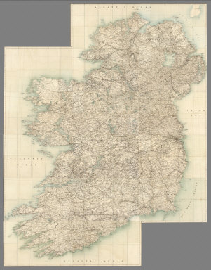
Author
Ireland. Ordnance Survey.
Full Title
(Composite) Sheets 1-16.
Publisher
Ordnance Survey of Ireland
Author
Stieler, Adolf
Full Title
(Composite of) England, Schotland, Ireland
Publisher
Justus Perthes
Author
[Stieler, Adolf, Petermann, A.]
Full Title
(Composite of) Stieler's Hand-Atlas No. 46, 47, 48. Grossbritannien, Ireland.
Publisher
Justus Perthus
Author
[Stieler, Adolf, Stulpnagel, F.v.]
Full Title
(Composite of) No. XVII, XIX, XX. Stieler's Hand-Atlas (No. 15b, 15c, 15d.) England und Wales, Schotland, Ireland.
Publisher
Justus Perthes
Author
Rocque, John
Full Title
(Composite map) A map of the Kingdom of Ireland, divided into provinces, counties and baronies. Southern section. Shewing the archbishopricks, bishopricks, cities, boroughs, market towns, villages, barracks, mountains, lakes, bays, rivers, bridges, ferries, passes, also the great, the branch & the by post roads together with the inland navigation, by J. Rocque, Chorographer to His Majesty. London, printed for Robt. Sayer, opposite Fetter Lane, Fleet Street, (1790?)
Publisher
Robert Sayer
Author
Vivien de St Martin, L.
Full Title
(Composite of) Carte des Iles Britanniques, formees de trois grandes parties: L'Irlande, L'Ecosse, et L'Angleterre; avec leurs Divisions en Comtes. Par L. Vivien, Geographe. 1824. Grave par Giraldon Bovinet. A Paris. Chez Menard et Desenne, Rue Git le Coeur, No. 8. 2eme Feuille.
Publisher
Vivien de St Martin, L.
1-15 of 15
|