Who What Where WhenREMOVE |
REFINE
Browse All : Composite Map of North America
1-18 of 18
Author
Jefferys, Thomas
Full Title
(Composite of) An Accurate Map Of North America. Describing and distinguishing the British and Spanish Dominions on the great Continent; According to the Definitive Treaty Concluded at Paris 10th Feby. 1763. Also all the West India Islands Belonging to, and possessed by the Several European Princes and States. The whole laid down according to the latest and Most authentick Improvements, By Eman Bowen Gegr: to His Majesty and John Gibson Engraver. London. Printed for Robert Sayer No. 53 Fleet Street as the Act Directs 2d. July 1775.
Publisher
Sayer and Bennett
Author
[Mexico Republica, (Espinosa y Tello, J.)]
Full Title
(Composite of) Carta General Para Las Navegaciones a la India Oriental Por El Mar Del Sur Y el grande Oceano que Separa el Continente Americano del Asiatico, Construida Segun las derrotas, Observaciones y trabajos de los mas Celebres Naveganles Espanoles Y Publicada por Orden del Exmo Sr. D. Guadalupe Victoria Primer Presidente de la Republica Mexico Ano de 1825. Los numberos de la Sonda son braxas de 6 pics de Burgos. (inset map on sheet 2) Plano Geometrico del Embocadero De S. Bernadino ano 1792. (inset map) Parte De La Isla De Samar.
Publisher
Republica Mexico
Author
Tanner, Henry S.
Full Title
(Composite of) North America. American Atlas. (1822)
Publisher
Henry Tanner
Author
Stein, Christ. Gottfr. Dan.
Full Title
(Composite of) Vereinigte Staaten von NordAmerika, nebst Mexico und Centralamerika. (with) San Francisco und Umgegend. (with) Die deutsche Colonie Wartburg, Staat Tennessee. (with) Die nordostlichen Staaten der Union. (with) Eisenbahnverbindung zwischen Chagres und Panama. (with) Isthmus von Panama. (with New York Bay). (with) Plan von Boston. Entworfen von G. Heck, gestochen under s. Leitung. Gestochen von R. Schmidt, H. Eberhardt u. J.L. v. Baehr. J.C. Hinrichs'sche Buchhandlung, Leipzig. (1865)
Publisher
J.C. Hinrichs'sche Buch- und Landkartenhandlung
Author
World Meteorological Organization (WMO)
Full Title
(Composite 0f) Average Amount of Precipitation mm, Year.
Publisher
WMO, Unesco, Cartographia
Author
Brue, Adrien Hubert, 1786-1832
Full Title
(Composite of) Carte encyprotype de l'Amerique Septentrionale, dediee et presentee a Monsieur. (with) Ile de Saint Domingue, dressee par H. Brue. (with) Ile de la Martinique. (with) Ile de la Guadeloupe, de Marie-Galante, la Desirade et les Saintes. Par H. Brue, Ingenieur-Geographe de S.A. Royale. Dirige par H. Brue. A Paris, Chez Desray ... (et) J. Goujon ..., 1815.
Publisher
Desray, Libraire-Editeur
Author
Brue, Adrien Hubert, 1786-1832
Full Title
(Composite of) Oceanie ou cinquieme partie du Monde. Comprenant l'archipel d'Asie, l'Australasie, la Polynesie, ou le continent de la Nouvelle-Hollande et les iles du Grand Ocean., &c. Ou outre und grande partie de l'Amerique et des cotes de l'Asie. Carte encyprotype dressee par H. Brue, Ingenieur-Geographe. H. Brue direx. A Paris, Chez Desray ... (et) J. Goujon ..., 1814.
Publisher
Desray, Libraire-Editeur
Author
[Kino, Eusebio Francisco, Pownall, Thomas, Robert Laurie & James Whittle]
Full Title
(Composite of) A new map of North America, with the West India Islands. (with) A particular map of Baffin and Hudson's Bay. (with) The passage by land to California discover'd by Father Eusebius Francis Kino a Jesuit, between the years 1692 and 1701 before which and for a considerable time since California has always been described in all charts & maps as an island. Divided according to the Preliminary Articles of Peace, signed at Versailles, 20 Jan. 1783, wherein are particularly distinguished the United States and the several provinces, governments &c. which compose the British Dominions, laid down according to the latest surveys, and corrected from the original materials of Goverr. Pownall, Membr. of Parliamt. London, Published by Laurie & Whittle, No. 53, Fleet Street, 12th May, 1794.
Publisher
Laurie & Whittle
Author
Stieler, Adolf
Full Title
(Composite of) Die Vereinigten Staaten von Nord-Amerika in 6 Blattern im Maassstabe von 1:3.700.000. Von A. Petermann. Bearbeitet v. H. Habenicht. Gest v. Eberhardt, Kuhn, Metzeroth & Weiler. Gotha: Justus Perthes. 1873.
Publisher
Justus Perthes
Author
Tanner, Henry S.
Full Title
(Composite of) A Map of North America, Constructed According To The Latest Information: by H.S. Tanner. Engraved & Published by H.S. Tanner. Philadelphia. 1822. American Atlas.
Publisher
Henry Tanner
Author
Arrowsmith, Aaron
Full Title
(Composite of) A map exhibiting all the new discoveries in the interior parts of North America, inscribed by permission to the Honorable Governor and Company of Adventurers of England trading into Hudson Bay, in testimony of their liberal communications to their most obedient and very humble servant, A. Arrowsmith, Hydrographer to H.R.H. the Prince of Wales. No. 10 Soho Square. January 1st, 1795 -- additions to 1811, 1818.
Publisher
A. Arrowsmith
Author
Wyld, James, 1812-1887
Full Title
(Composite to) Mexico The British Possessions In North America And The United States. London. Published By Jas. Wyld, Geographer To The Queen, Charing Cross East. 1846. James Wyld, Geographer to the Queen and to H.R.H. Prince Albert, Charing Cross, East, four doors from Trafalgar Square, London ... (inset) North America. (inset) Islands in the Pacific Ocean.
Publisher
James Wyld
Author
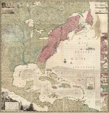
Popple, Henry
Full Title
(Composite Map of) A Map of the British Empire in America with the French and Spanish Settlements adjacent thereto. by Henry Popple.
Publisher
Willm. Henry Toms & R.W. Seale
Author
Anville, Jean Baptiste Bourguignon d, 1697-1782
Full Title
(Composite of) Amerique Septentrionale. Publiee sous les auspices de Monseigneur le Duc d'Orleans, Premier Prince du Sang. Par le Sr. d'Anville, M DCC XLVI (i.e., 1763?) Avec Privilege. Gravee par Guill? Delahaye. A Paris, chez l'Auteur, aus Galeries du Louvre.
Publisher
J.B.B. D'Anville.
Author
Popple, Henry
Full Title
(Composite Map of) A Map of the British Empire in America with the French and Spanish Settlements adjacent thereto. by Henry Popple. C. Lempriere inv. & del. B Baron Sculp. To the Queen's Most Excellent Majesty This Map is most humbly Inscribed by Your Majesty's most Dutiful, most Obedient, and most Humble Servant Henry Popple. London Engrav'd by Willm. Henry Toms & R.W. Seale, 1733.
Publisher
Willm. Henry Toms & R.W. Seale.
Author
Vandermaelen, Philippe, 1795-1869
Full Title
(Composite of) Amer. Sep. no. 1 - 76. (Dresse par Ph. Vandermaelen, lithographie par H. Ode. Quatrieme partie. - Amer. sept. Bruxelles. 1827)
Publisher
Ph. Vandermaelen
Author
[Tardieu, P.F., Tardieu, P. (Pierre Antoine), 1784-1869]
Full Title
(Composite of) A Map of Louisiana and Mexico. Carte de la Louisiane et du Mexique, Dressee par P. Tardieu fils aine, Gravee par P.A.F. Tardieu pere. Paris 1820. A Paris, chez: P.A.F. Tardieu, Place de l'Estrapade No. 34. C. Piequet, Geographe Graveur, Quai Conti No. 17. J. Goujon, Marchand de Cartes Geographiques, Rue du Bac No. 6. New York. Anthy. Girard , Mercht. Agent for the Author. Ecrit par Richomme.
Publisher
J. (Jean) Goujon, 1793-1826
Author
Vandermaelen, Philippe, 1795-1869
Full Title
(Composite of) Amer. Sep. no. 1 - 76 and Amer. Merid. no. 1 - 43. (Dresse par Ph. Vandermaelen, lithographie par H. Ode. 1827)
Publisher
Ph. Vandermaelen
1-18 of 18
|