Who What Where WhenREMOVEWHO
|
Author
Thomson, John
Full Title
(Composite of) Southern part of Edinburgh Shire (from actual surveys by James Knox ...). Published by John Thomson & Co., Edinburgh, 1821. (1832)
Publisher
[Baldwin & Cradock, John Cumming, John Thomson & Co.]
Author
Thomson, John
Full Title
(Composite of) Edinburgh Shire (from actual surveys by James Knox ...). Published by John Thomson & Co., Edinburgh, 1821. (1832)
Publisher
[Baldwin & Cradock, John Cumming, John Thomson & Co.]
Author
Thomson, John
Full Title
(Composite of) Northern part of Roxburgh Shire, Southern part of Roxburgh Shire. (with) View of Melrose Abbey, Church. (with) View of Jedburgh Abbey. Engd. by N.R. Hewitt, London. Published by John Thomson & Co., Edinburgh, 1822. (1832)
Publisher
[Baldwin & Cradock, John Cumming, John Thomson & Co.]
Author
[Crawford & Son, Thomson, John]
Full Title
(Composite of) Northern part of Dumfriesshire; surveyed by Crawford & Son, for the Atlas of Scotland. Published by John Thomson, Edinburgh, 1828. (1832)
Publisher
[Baldwin & Cradock, John Cumming, John Thomson & Co.]
Author
[Crawford & Son, Thomson, John]
Full Title
(Composite of) Southern part of Dumfriesshire; surveyed by Crawford & Son, for the Atlas of Scotland. Engraved by Sid(ne)y Hall. Published by John Thomson, Edinburgh, 1828. (1832)
Publisher
[Baldwin & Cradock, John Cumming, John Thomson & Co.]
Author
[Crawford & Son, Thomson, John]
Full Title
(Composite of) Dumfriesshire; surveyed by Crawford & Son, for the Atlas of Scotland. Engraved by Sid(ne)y Hall. Published by John Thomson, Edinburgh, 1828. (1832)
Publisher
[Baldwin & Cradock, John Cumming, John Thomson & Co.]
Author
Thomson, John
Full Title
(Composite of) Northern part ... Southern part of Kirkcudbright-Shire. (with) Town of Kirkcudbright, 1821. (with view) Dundrennan Abbey. Drawn by Willm. Johnson, Edinburgh. Engraved by Jn. Moffat, Edinburgh. Published by John Thomson & Co., Edinburgh, 1821. (1832)
Publisher
[Baldwin & Cradock, John Cumming, John Thomson & Co.]
Author
[Johnson, William, fl. 1806-1840, Thomson, John]
Full Title
(Composite of) Northern part of Ayrshire. Compiled from estate plans &c. by William Johnson, Land Surveyor, Edinburgh. Engraved by T. Clerk, Edinr. Published by John Thomson, Edinburgh, 1828. (1832)
Publisher
[Baldwin & Cradock, John Cumming, John Thomson & Co.]
Author
[Johnson, William, fl. 1806-1840, Thomson, John]
Full Title
((Composite of) Southern part of Ayrshire. Compiled from estate plans &c. by William Johnson, Land Surveyor, Edinburgh. Engraved by T. Clerk, Edinr. Published by John Thomson, Edinburgh, 1828. (1832)
Publisher
[Baldwin & Cradock, John Cumming, John Thomson & Co.]
Author
Thomson, John
Full Title
(Composite of) Northern part ... Southern part of Lanarkshire. (with) Glasgow. (with view) Bonnington Linn. Drawn by W. Johnson, Edinr. Engd. by Sid(ne)y. Hall, London. Published by John Thomson & Co., Edinburgh, 1822. (1832)
Publisher
[Baldwin & Cradock, John Cumming, John Thomson & Co.]
Author
Thomson, John
Full Title
(Composite of) Northern part ... Southern part of Argyllshire. (with) Campbeltown. Drawn by W. Johnson, Edinr. Engd. by J. & G. Menzies, Edinr. Published by John Thomson & Co., Edinburgh, 1824. (1832)
Publisher
[Baldwin & Cradock, John Cumming, John Thomson & Co.]
Author
[Johnson, William, fl. 1806-1840, Storie, James, Thomson, John]
Full Title
(Composite of) ... Part of Perthshire with Clackmannan. (with Perth). From Mr. James Storie's survey by William Johnson, Land Surveyor. Engraved by Sid(ne)y Hall, Bury Strt., Bloomsby. Published by John Thomson, Edinburgh, 1827. (1832)
Publisher
[Baldwin & Cradock, John Cumming, John Thomson & Co.]
Author
[Drysdale, Robert, Johnson, William, fl. 1806-1840, Martin, Alexander, Thomson, John]
Full Title
(Composite of) Western part of Fife with Kinross-Sh(ire). Eastern part of Fife-Sh(ire). Compiled from the surveys of John Ainslie & John Bell. Corrected by Alexander Martin, surveyor, Cupar; Robt. Drysdale, surr. Dunfermline, and William Johnson, surveyor, Edinr. Eng. by E. Butterworth. Published by John Thomson, Edinburgh, 1831. (1832)
Publisher
[Baldwin & Cradock, John Cumming, John Thomson & Co.]
Author
Thomson, John
Full Title
(Composite of) Northern part of Angusshire. Southern part of Angusshire. Engraved by Sid(ne)y Hall, Bury Strt., Bloomsby. Published by John Thomson & Co., Edinburgh, 1825. (1832)
Publisher
[Baldwin & Cradock, John Cumming, John Thomson & Co.]
Author
Thomson, John
Full Title
(Composite of) Northern part of Aberdeen & Banff-Shrs. Eng. by J. & G. Menzies, Edinr. Published by John Thomson, Edinburgh, 1826. (1832)
Publisher
[Baldwin & Cradock, John Cumming, John Thomson & Co.]
Author
Thomson, John
Full Title
(Composite of) South Aberdeen & Banff-Shrs. Eng. by E. Butterworth, Edinr. Published by John Thomson, Edinburgh, 1826. (1832)
Publisher
[Baldwin & Cradock, John Cumming, John Thomson & Co.]
Author
Thomson, John
Full Title
(Composite of) Aberdeen & Banff-Shrs. Eng. by E. Butterworth, Edinr. Published by John Thomson, Edinburgh, 1826. (1832)
Publisher
[Baldwin & Cradock, John Cumming, John Thomson & Co.]
Author
[Johnson, William, fl. 1806-1840, Thomson, John]
Full Title
(Composite of) Northern part of Inverness Shire. Compiled by William Johnson, Land Surveyor, Edinburgh. (Engraved by) J. & G. Menzies, Edinr. Published by John Thomson & Co., Edinburgh, 1830. (1832)
Publisher
[Baldwin & Cradock, John Cumming, John Thomson & Co.]
Author
[Johnson, William, fl. 1806-1840, Thomson, John]
Full Title
(Composite of) Southern part of Inverness Shire. Compiled by William Johnson, Land Surveyor, Edinburgh. (Engraved by) J. & G. Menzies, Edinr. Published by John Thomson & Co., Edinburgh, 1830. (1832)
Publisher
[Baldwin & Cradock, John Cumming, John Thomson & Co.]
Author
[Johnson, William, fl. 1806-1840, Thomson, John]
Full Title
(Composite of) Inverness Shire. Compiled by William Johnson, Land Surveyor, Edinburgh. (Engraved by) J. & G. Menzies, Edinr. Published by John Thomson & Co., Edinburgh, 1830. (1832)
Publisher
[Baldwin & Cradock, John Cumming, John Thomson & Co.]
Author
[Craig, John, Thomson, John]
Full Title
(Composite of) Northern part ... Southern part of Ross and Cromarty Shires. (with) Lewis, part of Ross Shire. Compiled from actual surveys by John Craig. Published by John Thomson, Edinburgh, 1826. (1832)
Publisher
[Baldwin & Cradock, John Cumming, John Thomson & Co.]
Author
[Johnson, William, fl. 1806-1840, Thomson, John]
Full Title
(Composite of) Ayrshire. Compiled from estate plans &c. by William Johnson, Land Surveyor, Edinburgh. Engraved by T. Clerk, Edinr. Published by John Thomson, Edinburgh, 1828. (1832)
Publisher
[Baldwin & Cradock, John Cumming, John Thomson & Co.]
Author
Brue, Adrien Hubert, 1786-1832
Full Title
(Composite of) Carte physique, routiere et politique de l'Italie, de la Suisse, du Royaume d'Illyrie et des provinces autrichiennes sur l'Adriatique. Redigee par A. Brue, Geographe du Roi. Paris, 1826. Chez l'Auteur, rue des Macons-Sorbonne, no. 9, et chez les principaux m(archan)ds de cartes geographiques.
Publisher
A. Brue
Author
Brue, Adrien Hubert, 1786-1832
Full Title
(Composite of) Carte detaillee en deux feuilles de l'Afrique et des iles qui en dependent ... par A. Brue, Geographe du Roi ... Paris, 1828. (with) Abyssinie et pays des Gallas. (with) Extremite sud de l'Afrique ou Colonie du cap, pays des Hottentots et des Betjouanas. (with) Archipel du nord-est de Madagascar. Chez l'Auteur, rue des Macons-Sorbonne, no. 9, et chez les principaux marchands de cartes geographiques.
Publisher
A. Brue
Author
Dunn, Samuel
Full Title
(Composite of) A general map of the world or terraqueous globe; with all the new discoveries and marginal delineations, containing the most interesting particulars in the solar, starry and mundane systems. By Saml. Dunn, Mathematician. London: printed for Rt. Sayer, Map, Chart and Printseller, 53 Fleet Street, 1787.
Publisher
Robert Sayer
Author
Kitchin, Thomas
Full Title
(Composite of) Europe divided into its empires, kingdoms, states, republics, &c. By Thos. Kitchin, Hydrographer to the King, with many additions and improvements from the latest surveys and observations. London, published by Robt. Sayer, Fleet Street, as the Act directs, Jany. 1st, 1787.
Publisher
Robert Sayer
Author
Kitchin, Thomas
Full Title
A compleat map of the British Isles, or Great Britain and Ireland with their respective roads and divisions. (By Thomas Kitchin). London: published by Robt. Sayer, no. 53 Fleet Street, as the Act directs, 1st Jany. 1788.
Publisher
Robert Sayer
Author
Rocque, John
Full Title
(Composite of) England and Wales, drawn from the most accurate surveys containing all the cities, boroughs, market towns & villages; in which are included all the improvements and observations both astronomical and topographical, which have been made by members of the Royal Society & others. Down to the present year, the whole corected & improv'd by John Rocque, Chorographer to his Majesty. London, printed for Robt. Sayer, Map & Printseller at the Golden Buck in Fleet Street, (1790?)
Publisher
Robert Sayer
Author
[Capitaine, Louis, ca. 1749-ca. 1797, Cassini family, Cassini, Cesar-Francois, 1714-1784]
Full Title
(Composite of) Carte de la France. Dediee au Roi. Par les directeurs et associes de la Carte de la France. 1790.
Publisher
Carte de la France Directeures
Author
[Flemming, Carl, Handtke, Friedrich H., Sohr, Karl]
Full Title
(Composite of) Sud-America. (in margin:) Sud-Amerika. Nach den neuesten u. besten Materialien bearbeitet u. gezeichnet von F. Handtke. Druck u. Verlag v. C. Flemming. Glogau, 1854 (1855)
Publisher
C. Flemming
Author
[Page, H.R. & Co., Brewster, Charles]
Full Title
(Composite of) Map of Nebraska. Compiled from Official Records in the Surveyor General's Office And Other Authentic Sources By Charles Brewster C.E. Published by H.R. Page & Co. Chicago, Ill. 1882. Copyright 1879 by H.R. Page & Co.
Publisher
H.R. Page & Co.
Author
Smith, J.L.
Full Title
(Composite of) Driving Map of Philadelphia and Vicinity. Published by J.L. Smith, 27 South Sixth St. Phila., Pa. 1882. Entered ... 1882 by J.L. Smith ... Washington.
Publisher
J.L. Smith
Author
MacCormac, Walter S.
Full Title
(Composite of) Map Of The Peninsula, Embracing Delaware And The Eastern Shore Of Maryland And Virginia, Compiled from U.S. Coast, and other Actual Surveys, and recent information obtained from various sources. By Walter S. MacCormac, Civ. Eng. Published by Smith & Stroup, Nos. 52 & 54 North Sixth Street, Philadelphia. 1879. Entered ... 1878, by E.W Smith ... Washington.
Publisher
Smith & Stroup
Author
[Smith, J.L., Smith, A. DW.]
Full Title
(Composite of) General Map Of The Anthracite Coal Fields Of Pennsylvania And Adjoining Counties Showing The Position Of Each Colliery. By A. DW. Smith, Mining Engineer. Wilkes-Barre, Penna. Published by J.L. Smith, Map Publisher, 27 S. 6th St., Philadelphia 1899. Copyrighted 1899 By A. DW. Smith. (inset) Map Showing The Railroad Outlets Of The Anthracite Coal Regions Of Pennsylvania.
Publisher
J.L. Smith
Author
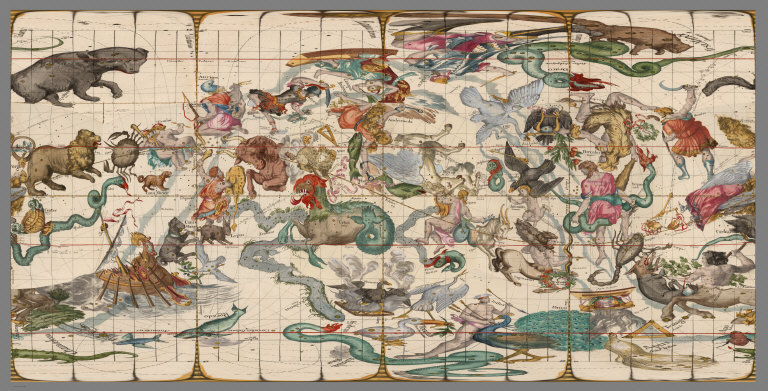
Pardies, Ignace Gaston, 1636-1673
Full Title
(Composite of) Plates 1 - 6 on Cubic Projection - arranged as published.
Publisher
Sebastien Mabre-Cramoisy
Author
Pardies, Ignace Gaston, 1636-1673
Full Title
(Composite of) Plates 1 - 6 on Cubic Projection - Poles adjacent to Plate 5
Publisher
Sebastien Mabre-Cramoisy
Author
Pardies, Ignace Gaston, 1636-1673
Full Title
(Composite of): Plates 1, 2, 5 Joined in a 3D cube
Publisher
Sebastien Mabre-Cramoisy
Author
Pardies, Ignace Gaston, 1636-1673
Full Title
(Composite of): Plates 1, 3, 4 Joined in a 3D cube
Publisher
Sebastien Mabre-Cramoisy
Author
Pardies, Ignace Gaston, 1636-1673
Full Title
Plate 1 in Gnomonic Projection with adjoining Plates. Viewed in GIS application.
Publisher
Sebastien Mabre-Cramoisy
Author
Pardies, Ignace Gaston, 1636-1673
Full Title
Plate 2 in Gnomonic Projection with adjoining Plates. Viewed in GIS application.
Publisher
Sebastien Mabre-Cramoisy
Author
Pardies, Ignace Gaston, 1636-1673
Full Title
Plate 3 in Gnomonic Projection with adjoining Plates. Viewed in GIS application.
Publisher
Sebastien Mabre-Cramoisy
Author
Pardies, Ignace Gaston, 1636-1673
Full Title
Plate 4 in Gnomonic Projection with adjoining Plates. Viewed in GIS application.
Publisher
Sebastien Mabre-Cramoisy
Author
Pardies, Ignace Gaston, 1636-1673
Full Title
Plate 6 in Gnomonic Projection with adjoining Plates. Viewed in GIS application.
Publisher
Sebastien Mabre-Cramoisy
Author
Pardies, Ignace Gaston, 1636-1673
Full Title
Plate 1 and adjoining plates in Orthographic Projection, Transformed from Gnomonic.
Publisher
Sebastien Mabre-Cramoisy
Author
Pardies, Ignace Gaston, 1636-1673
Full Title
Plate 2 and adjoining plates in Orthographic Projection, Transformed from Gnomonic.
Publisher
Sebastien Mabre-Cramoisy
Author
Pardies, Ignace Gaston, 1636-1673
Full Title
Plate 3 and adjoining plates in Orthographic Projection, Transformed from Gnomonic.
Publisher
Sebastien Mabre-Cramoisy
Author
Pardies, Ignace Gaston, 1636-1673
Full Title
Plate 4 and adjoining plates in Orthographic Projection, Transformed from Gnomonic.
Publisher
Sebastien Mabre-Cramoisy
Author
Pardies, Ignace Gaston, 1636-1673
Full Title
Plate 5 and adjoining plates in Orthographic Projection, Transformed from Gnomonic.
Publisher
Sebastien Mabre-Cramoisy
Author
Pardies, Ignace Gaston, 1636-1673
Full Title
Plate 6 and adjoining plates in Orthographic Projection, Transformed from Gnomonic.
Publisher
Sebastien Mabre-Cramoisy
|