Who What Where WhenREMOVEWHERE
WHOShow More |
Author
[Anville, Jean Baptiste Bourguignon d, 1697-1782, Robert Laurie & James Whittle]
Full Title
(Composite of) A map of South America containing Tierra-Firma, Guayana, New Granada, Amazonia, Brasil, Peru, Paraguay, Chaco, Tucuman, Chili and Patagonia, from Mr. d'Anville with several improvements and additions, and the newest discoveries. (with) A chart of Falkland's Islands named by the French Malouine Islands and discovered by Hawkins, in the year 1593. London, Published by Laurie & Whittle, No. 53 Fleet Street, as the act directs 12th May, 1794.
Publisher
Laurie & Whittle
Author
[Bartholomew, J. G. (John George), 1860-1920, John Bartholomew & Co.]
Full Title
(Composite of) Section maps of India. The Edinburgh Geographical Institute, John Bartholomew & Co. "The Times" atlas. (London: The Times, 1922)
Publisher
The Times
Author
[Bartholomew, J. G. (John George), 1860-1920, John Bartholomew and Son]
Full Title
(Composite of) Section maps of Africa. The Edinburgh Geographical Institute, John Bartholomew & Son, Ltd. "The Times" atlas. (London: The Times, 1922)
Publisher
The Times
Author
Lisle, Guillaume de, 1675-1726
Full Title
(Composite of) Le Cours du Rhin ... et le pays adjacens. Par Guill. de l'Isle, de l'Academ. Rle. des Sciences. A Paris, chez l'Auteur sur le Quai de l'Horloge a l'Aigle d'Or, 1704, avec Privilege. Grave par Liebaux le fils.
Publisher
Guillaume DeLisle, Quai de l'Horloge a l'Aigle d'Or
Author
Lisle, Guillaume de, 1675-1726
Full Title
(Composite of) Partie ... de la Souabe.Par G. Del'Isle de l'Academie Royale des Sciences. A Paris, chez l'Auteur sur le Quai de l'Horloge, avec Privilege du Roy, 1704.
Publisher
Guillaume DeLisle, Quai de l'Horloge
Author
Lisle, Guillaume de, 1675-1726
Full Title
(Composite of) Carte du Piemont et du Monferrat. Dressee sur plusieurs cartes manuscrites ou imprimees, rectifiees par quelques observations, par Guillaume Del'Isle de l'Academie Royale des Sciences. Gravee par Liebaux le fils. A Paris, chez l'Auteur sur le Quai de l'Horloge, avec Privilege Avril 1707.
Publisher
Guillaume DeLisle, Quai de l'Horloge
Author
Lisle, Guillaume de, 1675-1726
Full Title
(Composite of) Theatrum historicum ad annum Christi quadringentesimu. in quo tum Imperii Romani tu. Barbarorum circumincolentiu. status ob oculos ponitur. Auctore Guillelmo Delisle e Regia Scientiarum Academia. Parisiis, apud Autorem in Ripa vulgo dicta le Quai de l'Horloge cum Privilegio Regis ad Vicennum, 1705. Des Rosiers sc.
Publisher
Guillaume DeLisle, Quai de l'Horloge
Author
[Bemis, Geo. P., Everts & Co., L.H. Everts & Co., Mann, Adin, 1816-1903, Smith, George M.]
Full Title
(Composite of) Map of Omaha City. Prepared for this work under the direction of the publishers, assisted by Geo. P. Bemis ... Compiled and drawn by Adin Mann, Civil Engineer. Assisted by Geo. Smith, Co. Surveyor of Douglas Co. (Philadelphia, Everts & Kirk, 1885)
Publisher
Everts & Kirk
Author
[Lisle, Guillaume de, 1675-1726, Verden, Carl van]
Full Title
(Composite of) Carte marine de la Mer Caspiene. Levee suivant les ordres de S.M. Czariene, Par Mr. Carl Vanverden en 1719, 1720 et 1721. Et reduite au meridien de Paris par Guillaume Delisle, Premier Geographe du Roy, de l'Academie Royale des Sciences. A Paris, Chez le Sr. Delisle, Quay de l'horloge, avec Privilege du Roy, (1721?)
Publisher
Guillaume DeLisle, Quai de l'Horloge
Author
[Bartholomew, J. G. (John George), 1860-1920, John Bartholomew and Son]
Full Title
(Composite of) Cape Province, Transvaal, &c. The Edinburgh Geographical Institute, John Bartholomew & Son, Ltd. "The Times" atlas. (London: The Times, 1922)
Publisher
The Times
Author
[Bartholomew, J. G. (John George), 1860-1920, John Bartholomew and Son]
Full Title
(Composite of) Section maps of Africa on scale of 1:5,000,000. The Edinburgh Geographical Institute, John Bartholomew & Son, Ltd. "The Times" atlas. (London: The Times, 1922)
Publisher
The Times
Author
[Bartholomew, J. G. (John George), 1860-1920, John Bartholomew & Co.]
Full Title
(Composite of) Section maps of the Atlantic Ocean on Mercators projection. The Edinburgh Geographical Institute, John Bartholomew & Co. "The Times" atlas. (London: The Times, 1922)
Publisher
The Times
Author
[Bartholomew, J. G. (John George), 1860-1920, John Bartholomew and Son]
Full Title
(Composite of) North-eastern, Western Canada. The Edinburgh Geographical Institute, John Bartholomew & Son, Ltd. "The Times" atlas. (London: The Times, 1922)
Publisher
The Times
Author
[Bartholomew, J. G. (John George), 1860-1920, John Bartholomew and Son]
Full Title
(Composite of) Section maps of Canada on scale of 1:2,500,000. The Edinburgh Geographical Institute, John Bartholomew & Son, Ltd. "The Times" atlas. (London: The Times, 1922)
Publisher
The Times
Author
[Bartholomew, J. G. (John George), 1860-1920, John Bartholomew & Co.]
Full Title
(Composite of) United States ... section. The Edinburgh Geographical Institute, John Bartholomew & Co. "The Times" atlas. (London: The Times, 1922)
Publisher
The Times
Author
[Bartholomew, J. G. (John George), 1860-1920, John Bartholomew and Son]
Full Title
(Composite of) South America, northern, southern section. The Edinburgh Geographical Institute, John Bartholomew & Son, Ltd. "The Times" atlas. (London: The Times, 1922)
Publisher
The Times
Author
[Bartholomew, J. G. (John George), 1860-1920, John Bartholomew and Son]
Full Title
(Composite of) South, North Pacific Ocean on Mercators projection. The Edinburgh Geographical Institute, John Bartholomew & Son, Ltd. "The Times" atlas. (London: The Times, 1922)
Publisher
The Times
Author
[Bartholomew, J. G. (John George), 1860-1920, John Bartholomew & Co.]
Full Title
(Composite of) Australia - eastern, western section. The Edinburgh Geographical Institute, John Bartholomew & Co. "The Times" atlas. (London: The Times, 1922)
Publisher
The Times
Author
[Bartholomew, J. G. (John George), 1860-1920, John Bartholomew & Co.]
Full Title
(Composite of) Section maps of Australia on scale of 1:2,500,000. The Edinburgh Geographical Institute, John Bartholomew & Co. "The Times" atlas. (London: The Times, 1922)
Publisher
The Times
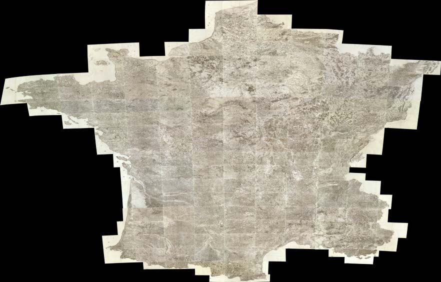
Full Title
(Composite of) Carte de France. Levee par ordre du Roy. (1750-1815)
Publisher
Carte de la France Directeures
Author
[Bartholomew, J. G. (John George), 1860-1920, John Bartholomew and Son]
Full Title
(Composite of) Western, Eastern Europe - communications. The Edinburgh Geographical Institute, John Bartholomew & Son, Ltd. "The Times" atlas. (London: The Times, 1922)
Publisher
The Times
Author
Sayer, Robert
Full Title
(Composite of) A new map of the whole continent of America. Divided into north and south and West Indies, wherein are exactly described the United States of North America as well as the several European possessions according to the Preliminaries of Peace signed at Versailles Jan. 20, 1783. Compiled from Mr. d'Anville's maps of that continent, with the addition of the Spanish discoveries in 1775 to the north of California & corrected in the several parts belonging to Great Britain from the original materials of Governor Pownall, MP. London, printed for Robt. Sayer, Map, Chart & Printseller, no. 53, Fleet Street, as the Act directs 15th August, 1786.
Publisher
Robert Sayer
Author
Lisle, Guillaume de, 1675-1726
Full Title
(Composite of) Carte de la Terre Ferme, du Perou, du Bresil, et du Pays des Amazones ; Carte du Paraguay, du Chili, du Detroit de Magellan &c. Par Guillaume De l'Isle, Geographe de l'Academie Royale des Sciences. Gravee par Liebaux le fils. A Paris, chez l'Auteur sur le Quai de l'Horloge, avec Privilege du Roi pour 20 ans, 1703 (between 1708 and 1718)
Publisher
Guillaume DeLisle, Quai de l'Horloge
Author
Anville, Jean Baptiste Bourguignon d, 1697-1782
Full Title
(Composite of) Carte de l'Inde. Dressee pour la Compagnie des Indies par le Sr. d'Anville, Secretaire de S.A.S.Mgr. le Duc d'Orleans. (Paris), Novembre 1752. (Grave par) Guill? De-la-Haye.
Publisher
J.B.B. D'Anville.
Author
Anville, Jean Baptiste Bourguignon d, 1697-1782
Full Title
(Composite of) Carte particuliere de la Cote occidentale de l'Afrique, depuis le Cap Blanc jusqu'au Cap de Verga, et du cours des rivieres de Senega et de Gambie, en ce qui est connu. Dressee pour la Compagnie des Indes par le Sr. d'Anville, en Juillet M DCC LI. Grave par Guill? De la Haye.
Publisher
J.B.B. D'Anville.
Author
Anville, Jean Baptiste Bourguignon d, 1697-1782
Full Title
(Composite of) Canada, Louisiane et Terres Angloises. Par le Sr. d'Anville, de l'Academie Rle. des Inscriptions et Belles-Lettres, et de celle des Sciences de Petersbourg, Secretaire de S.A.S. Mgr. le Duc d'Orleans. Novembre MDCCLV. Sous le Privilege de l'Academie. Chez l'Auteur, aux Galeries du Louvre. Grave par) G. De-la-Haye)
Publisher
J.B.B. D'Anville.
Author
[Stieler, Adolf, Stulpnagel, F.v.]
Full Title
(Composite of) Stieler's Hand-Atlas No. 13b, 13c, 13d, 13e. Spanien und Portugal in IV Blattern.
Publisher
Justus Perthes
Author
[Stieler, Adolf, Stulpnagel, F.v.]
Full Title
(Composite of) No. XIV, XV, XVI. Stieler's Hand-Atlas (No. 14b, 14c, 14d.) Nordostliche Theil,, Der Der Nord-Westliche Theil, Sudliche Theil von Frankreich.
Publisher
Justus Perthes
Author
[Stieler, Adolf, Stulpnagel, F.v.]
Full Title
(Composite of) No. XVII, XIX, XX. Stieler's Hand-Atlas (No. 15b, 15c, 15d.) England und Wales, Schotland, Ireland.
Publisher
Justus Perthes
Author
Stieler, Adolf
Full Title
(Composite of) Nos. XXI, XXVII, XXIX, XXXI, XXXII. Stieler's Hand-Atlas Deutschland ....
Publisher
Justus Perthes
Author
Stieler, Adolf
Full Title
(Composite of) No. XXXVI, XXXVII. Stieler's Hand-Atlas Italien.
Publisher
Justus Perthes
Author
Stieler, Adolf
Full Title
(Composite of) Stieler's Hand-Atlas Europaisches Russland (Russia in Europe).
Publisher
Justus Perthes
Author
Stieler, Adolf
Full Title
(Composite of) Ost-Europa In 6 Blattern, Enthalten
Publisher
Justus Perthes
Author
Stieler, Adolf
Full Title
(Composite of) No. LII, No. LIINo. LIIIb. Stieler's Hand-Atlas (No. 45a, 45b, 45c). Africa.
Publisher
Justus Perthes
Author
[Stieler, Adolf, Stulpnagel, F.v.]
Full Title
(Composite of) No. LXI, No. LX. Stieler's Hand-Atlas (No. 49a, 49b). Sud-Amerika in zwei Blattern.
Publisher
Justus Perthes
Author
Akademiia nauk SSSR
Full Title
(Composite of) (Plan stolichnago goroda Sanktpeterburga s izobraheniem znatiieshikh onago prospektov, izdannyi trudami Imperatorskoi Akademii nauk i khudozhestv. Plan de la ville de St. Petersbourg avec ses principales vues dessine & grave sous la direction de l'Academie imperiale des sciences et des arts).
Publisher
Imperatorskoi Akademii nauk i khudozhestv
Author
[Derfelden van Hinderstein, G.F. Baron von, Tindal, George August, Ministerie van Kolonien]
Full Title
(Composite Map) Ugemeene Kaart van Nederlandsch Oostindie, met hoogstdeszelfs toestemming opgedragen aan Zijne Majesteit den Koning der Nederlanden ... te zamengesteld door G.F. Baron von Derfelden van Hinderstein ... 1842. (insets) Halmahera. Straat Prinses Marianne. Honische Baai. Celebes. Oranje Nassau.
Publisher
(Ministerie van Koloniën)
Author
Baist, G.W.
Full Title
(Composite of) : Baist's Map of the San Fernando Valley, Los Angeles, California, Plates 46, 47, 48, 49.
Publisher
G. W. Baist
Author
Rizzi Zannoni, Giovanni Antonio (1736-1814)
Full Title
(Composite of) Carta del' itinerarj militari da Bologna a tutto il Regno di Napoli ordinata da S.M Giuseppe Napoleone I. diretta dal Gen. Div. Parisi costruita da P. Colletta Ten. Cotto del Genio' Leop. Laperuta, dis. (engraved by) Gius. Guerra Inc. (to accompany) Atlante geografico del regno di Napoli 1808.
Publisher
Giuseppe Guerra
Author
Rizzi Zannoni, Giovanni Antonio (1736-1814)
Full Title
(Composite of) No.1 - 31. Regno di Napoli.
Publisher
Giuseppe Guerra
Author
[Forbes, Edward, 1815-1854, Johnston, Alexander Keith, 1804-1871]
Full Title
(Composite of) Geological & palaeontological map of the British Islands. By A.K. Johnston, F.R.G.S. From the sketches & notes of Professor Edward Forbes, F.R.S. of Kings College London & of the Government School of Mines, President of the Geological Society. Engraved by W. & A.K. Johnston. William Blackwood & Sons, Edinburgh & London. 1st March 1854, (1856)
Publisher
William Blackwood & Sons
Author
Scarborough Company
Full Title
(Composite of) Sheets 1 - 5. Scarborough's Complete Road Atlas of Massachusetts and Rhode Island. Copyright, 1905, by the Scarborough Co., 144 Essex St. Boston, Mass.
Publisher
The Scarborough Company
Author
[Beers, F.W. (Frederick W.), Cramer, Louis H.]
Full Title
(Composite) Saratoga Springs, New York.
Publisher
J.B. Beers & Co.
Author
[Beers, F.W. (Frederick W.), Cramer, Louis H.]
Full Title
(Composite) Ballston Spa. Towns of Milton & Ballston.
Publisher
J.B. Beers & Co.
Author
Schubert, Friedrich Theodor
Full Title
(Composite map to) Kriegsstrassen Karte eines Theiles von Russland und der angraenzenden laender; nach der unter der Leitung des Russ. kaiserlichen Generalstabes vom General Major Schubert im Masstabe von 1/1680000 im Jahre 1829 herausgegebenen Karte auf das Mass von 1/1400000 vergrossert, von dem k.k. osterr. Generalquartiermeisterstabe herausgegeben im Jahre 1837.
Publisher
Generalquartiermeisterstab
Author
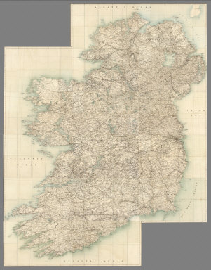
Ireland. Ordnance Survey.
Full Title
(Composite) Sheets 1-16.
Publisher
Ordnance Survey of Ireland
Author
Stieler, Adolf
Full Title
(Composite of) Die Vereinigten Staaten von Nord-Amerika in 6 Blattern im Maassstabe von 1:3.700.000. Von A. Petermann. Bearbeitet v. H. Habenicht. Gest v. Eberhardt, Kuhn, Metzeroth & Weiler. Gotha: Justus Perthes. 1873.
Publisher
Justus Perthes
Author
[Stieler, Adolf, Vogel, C.]
Full Title
(Composite of) Stieler's Hand-Atlas ... Deutschland
Publisher
Justus Perthes
Author
Stieler, Adolf
Full Title
(Composite of) Karte von Deutschland den Konigr. der Niederlande dem Kgr. Belgien, der Schweiz und den angranzenden Landern, bis Paris, Lyon, Turin, Mailand, Venedig, Ofen, Konnigsberg, in XXV Blatt.
Publisher
Justus Perthes
|