Browse All

1875 Huntsville, Richland, Zanesfield, and De … County Atlas Huntsville, Oliver F. Waegon. Richland, … |

1875 Bellefontaine, Logan County, Ohio. County Atlas Map of Bellefontaine, Logan Co. Compiled … |

1875 West Liberty, Logan County, Ohio. 1874. County Atlas West Liberty. 1874. Oliver F. Waegon C.E … |
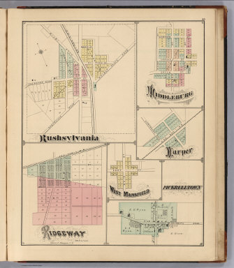
1875 Rushsylvania, Ridgeway, Middleburg, Harp … County Atlas Rushsylvania. Ridgeway, Oliver F. Waegon … |

1875 Last Liberty. Logansville. Northwood. Ch … County Atlas Last Liberty. Logansville. Northwood. Ch … |

1875 Washington Township, Logan County, Ohio. … County Atlas Map of Washington Township. (View) M.E. … |

1875 View: Residences of C.H. Custenborder. R … County Atlas (View) Res. of C.H. Custenborder. Res. a … |

1875 Text: Business Directory of Logan County … County Atlas (Text Page) Business Directory of Logan … |

1875 Text: Business Directory of Logan County … County Atlas (Text Page) Business Directory of Logan … |

1875 Text: Business Directory of Logan County … County Atlas (Text Page) Business Directory of Logan … |

1875 Covers: Atlas Of Saint John City And Cou … County Atlas (Covers to) Atlas Of Saint John City And … |

1875 Title Page: Atlas Of Saint John City And … County Atlas (Title Page) Atlas Of Saint John City An … |

1875 Table of Contents: Atlas Of Saint John C … County Atlas (Table of Contents for) Atlas Of Saint J … |

1875 Counties of St. John & Kings, New Brunsw … County Atlas Plan of the Counties of St. John & Kings … |
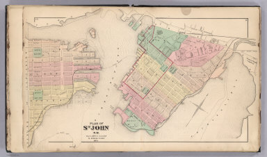
1875 St. John, N.B. (New Brunswick). County Atlas Plan of St. John, N.B. by Roe & Colby. ! … |

1875 St. John: Dukes & Sydney Wards. (New Bru … County Atlas Plan of St. John, Dukes & Sydney Wards. … |

1875 Plan of St. John, Queens Ward. (New Brun … County Atlas Plan of St. John, Queens Ward. (New Brun … |

1875 St. John: Kings Ward. (New Brunswick). County Atlas Plans of St. John, Kings Ward. (New Brun … |

1875 St. John: Wellington & Prince Wards. (Ne … County Atlas Plans of St. John, Wellington & Prince W … |

1875 St. John: Brooks Ward, Carleton. (New Br … County Atlas Plans of St. John, Brooks Ward, Carleton … |

1875 St. John: Guys & Albert Wards, Carleton. … County Atlas Plans of St. John, Guys & Albert Wards, … |

1875 Composite: St. John City. (New Brunswick … County Atlas (Composite of) St. John City. (New Bruns … |

1875 Portland (New Brunswick). County Atlas Town of Portland. (New Brunswick). |

1875 Portland, Village Plan No. 1. (New Bruns … County Atlas Portland, Village Plan No. 1. (New Bruns … |

1875 Portland, Village Plan No. 2. (New Bruns … County Atlas Portland, Village Plan No. 2. (New Bruns … |

1875 Portland, Village Plan No. 3. (New Bruns … County Atlas Portland, Village Plan No. 3. (New Bruns … |

1875 Portland, Village Plan No. 4. (New Bruns … County Atlas Portland, Village Plan No. 4. (New Bruns … |

1875 Parish of Lancaster. (New Brunswick). County Atlas Parish of Lancaster. (New Brunswick). |

1875 Part of the Parish of Lancaster No. 1. ( … County Atlas Part of the Parish of Lancaster No. 1. ( … |

1875 Part of the Parish of Lancaster No. 2. ( … County Atlas Part of the Parish of Lancaster No. 2. ( … |

1875 Fairville. (New Brunswick). County Atlas Fairville. (New Brunswick). |

1875 Musquash. (New Brunswick). County Atlas Musquash. (New Brunswick). |

1875 South Bay. (New Brunswick). County Atlas South Bay. (New Brunswick). |

1875 Parish of Simonds. (New Brunswick). County Atlas Parish of Simonds. (New Brunswick). |

1875 Part of Simonds including Crouchville, C … County Atlas Part of Simonds including Crouchville, C … |

1875 Parish of St. Martins. (New Brunswick). County Atlas Parish of St. Martins. (New Brunswick). |

1875 Quaco. (New Brunswick). County Atlas Quaco. (New Brunswick). |

1875 Text: St. John Subscribers' Business Dir … County Atlas (Text Page) St. John Subscribers' Busine … |

1875 Text: St. John Business Directory - Cont … County Atlas (Text Page) St. John Business Directory … |

1875 Covers: Illustrated Atlas Map Of Pike Co … County Atlas (Covers to) Illustrated Atlas Map Of Pik … |

1875 Title: Illustrated Atlas Map Of Pike Cou … County Atlas (Title Page) Illustrated Atlas Map Of Pi … |

1875 Index Page: Table of Contents. County Atlas (Index Page) Table of Contents. |

1875 Statistical Table: Statistics of the Pop … County Atlas (Statistical Table) Statistics of the Po … |

1875 Township and Rail Road Map of Missouri. County Atlas Township & Rail Road Map of Missouri Sho … |

1875 Text: History of Pike County, MIssouri. … County Atlas (Text Page) History of Pike County, MIss … |

1875 Pike County, Missouri. County Atlas Sectional Map of Pike County, Missouri. |

1875 View: Pike County Court House, Missouri. County Atlas (View) Pike County Court House. |

1875 Text: (A Portion of Our Patrons - Contin … County Atlas (Text Page) (A Portion of Our Patrons - … |

1875 Township 52 North, Range 2 East, Pike Co … County Atlas Township 52 North, Range 2 East. Paynesv … |

1875 Township 52 North, Range 1 East, Pike Co … County Atlas Township 52 North, Range 1 East. |