Who What Where When |
REFINE
Browse All : Covers from 1836
1-19 of 19
Author
[Mitchell, Samuel Augustus, Young, James H.]
Full Title
(Covers to) A New Map Of Texas, With The Contiguous American & Mexican States by J.H. Young. Philadelphia: Published by S. Augustus Mitchell. 1836. Sold by Mitchell & Hinman No. 6 North Fifth Street. Engraved by J.H. Young. Entered ... 1835 by S. Augustus Mitchell ... Pennsylvania.
Publisher
S.A. Mitchell
Author
Mitchell, Samuel Augustus
Full Title
(Covers to) Map Of The States Of North Carolina South Carolina and Georgia. Philadelphia: Published by S. Augustus Mitchell. 1836. Sold By Mitchell & Hinman No. 6 North Fifth Street. Entered ... 1835, by S. Augustus Mitchell ... Pennsylvania. Engraved by J.H. Young. (inset) Vicinity Of Charleston.
Publisher
S. Augustus Mitchell
Author
Tanner, Henry S.
Full Title
(Covers to) Illinois And Missouri. By H.S. Tanner. 1836. Published by H.S. Tanner, Philadelphia. Entered ... 1836, by H.S. Tanner ... Pennsylvania. Engraved by H.S. Tanner & Assistants.
Publisher
H.S. Tanner
Author
Mitchell, Samuel Augustus
Full Title
(Covers to) Map of the state of Missouri and territory of Arkansas compiled from the latest authorities. Philadelphia, published by S. Augustus Mitchell. 1836. Sold by Mitchell & Hinman, No. 6 North Fifth Street. Entered ... 1835, by S. Augustus Mitchell ... Pennsylvania.
Publisher
S. Augustus Mitchell
Author
Mitchell, Samuel Augustus
Full Title
(Inside covers to) Map of the state of Missouri and territory of Arkansas compiled from the latest authorities. Philadelphia, published by S. Augustus Mitchell. 1836. Sold by Mitchell & Hinman, No. 6 North Fifth Street. Entered ... 1835, by S. Augustus Mitchell ... Pennsylvania.
Publisher
S. Augustus Mitchell
Author
[Hammond, John T., Squire, B.S.]
Full Title
(Covers to) Map of Illinois with a Plan of Chicago. Published by B.S. Squire Jr. New-York 1836. Entered ... 1st day of Decr. in the year 1835 by Bela S. Squire Jr. ... New York. Engd. by J.T. Hammond N. York.
Publisher
B.S. Squire
Author
[Colton, J.H., Burr, David H.]
Full Title
(Covers to) Ohio. By David H. Burr. Published By J.H. Colton & Co. New-York. 1836. 4 Spruce Street. Entered ... 1833 by J.H. Colton & Co ... New York. Engraved & Printed by S. Stiles & Co. (inset) Cincinnati. (with) Portsmouth on the Ohio River. P. Desobry's Lithy. 171 B. Way N. York.
Publisher
J.H. Colton & Co.
Author
Farmer, John
Full Title
(Covers to) An Improved Edition Of A Map of the Surveyed Part Of The Territory Of Michigan By John Farmer. 1836. Engraved by J. Farmer. Entered ... by John Farmer on the 4th day of July A.D. 1835. (inset) Map of the Straits of Michillimackinac, from Actual Survey ... By John Farmer. 1835. (inset) Map of Pte. Ste. Ignace. (inset) Map of the most important part of the Lead Mine District near the Mississippi River... by John Farmer. 1835. (inset) Map of the Private Claims at Green Bay, from Actual Survey. (inset) Map of Michillimackinac Isle.
Publisher
John Farmer
Author
[Disturnell, John, David H., 1803-1875]
Full Title
(Covers to) Guide To The Environs Of The City Of New York ... Accompanied By A Correct Map. Price 50 Cents. Published By J. Disturnell. 1836. (with) Map Of New-York and its Vicinity, Drawn by D.H. Burr, for New York as it is, in 1836. Published by J. Disturnell, No. 156 Broadway, New-York. Engraved by S. Stiles & Co. Merchs. Exch. N.Y. Entered ... 1834, by J. Disturnell ... New York.
Publisher
J. Disturnell.
Author
Webster, James
Full Title
(Covers to) Travellers Guide and Statistical View of the United States. Published by J.W. Webster, New York. Entered ... 1834, by J.W. Webster ... New-York. (with) Map of the United States Published by J. Webster, New York, 1836. Entered ... the 26th day of March 1833 by James Webster ... New York.
Publisher
James Webster.
Author
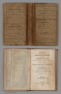
Steele, Oliver G.
Full Title
(Covers to) Steele's Western Guide Book, And Emigrant's Directory, Containing Different Routes Through The States Of New-York, Ohio, Indiana, Illinois And Michigan, With Short Descriptions Of The Climate, Soil, Productions, Prospects, &c. Fifth Edition. Greatly Improved And Enlarged. Buffalo: Published By Oliver G. Steele, 1836. (on verso) Entered ... in the year 1836 ... Press of O.G. Steele. (with) Steele's Map Of Ohio Indiana Illinois & Michigan From the Latest Authorities. Buffalo 1836. Entered ... 1835 by O.G. Steele ... Engraved by J.G. Darby, Buffalo N.Y. (inset) The Southern Part of Illinois.
Publisher
Oliver G. Steele.
Author
[Mitchell, Samuel Augustus, Young, James H.]
Full Title
(Covers to) Mitchell's Traveller's Guide Through The United States, Containing The Principal Cities, Towns, &c. ... Illustrated By An Accurate Map Of The United States. Philadelphia: Hinman & Dutton, No. 6 North Fifth Street. 1836. (on verso) Entered ... 1836, by Mitchell & Hinman ... Pennsylvania. Stereotyped by John Fagan ... Philadelphia. (with map) Mitchell's Travellers Guide Through The United States. A Map Of The Roads, Distances, Steam Boat & Canal Routes &c. By J.H. Young Philadelphia. Published by S. Augustus Mitchell. 1836. Engraved On Steel By J.H. Young & D. Haines. Entered ... 1834 by S. Augustus Mitchell ... Pennsylvania. (with 9 inset maps).
Publisher
Mitchell & Hinman
Author
Tanner, Henry S.
Full Title
(Covers to) The American Traveller; Or Guide Through the United States. Containing Brief Notices of the Several States, Cities, Principal Towns ... Second Edition. By H.S. Tanner. Philadelphia: Published by the Author, Shakespeare Buildings. 1836. (on verso) Entered ... 1836, By H.S. Tanner ... Pennsylvania.
Publisher
H.S. Tanner
Author
Disturnell, John
Full Title
(Covers to) The Traveller's Guide Through The State Of New York, Canada, &c. Embracing a General Description Of The City Of New York; The Hudson River Guide ... Accompanied By Correct Maps. New-York: Published By J. Disturnell, No. 156 Broadway. MDCCCXXXVI. Entered ... 1836, By John Disturnell ... New-York. J.W. Bell, Printer, 17 Ann-street. (with map) Miniature Plan of the City of New-York. Engraved by J.F. Morin. 1836. Published by Disturnell ... (with map) Hudson River & Vicinity. Drawn By David H. Burr. Published By J. Disturnell ... 1836. Entered ... 1834 by J. Disturnell ... New York. S. Stiles & Co. N.Y. (with map) Map Of The State of New York With the Latest Improvements ... Published by J. Disturnell. New York, 1836. Entered ... 1836 by John Disturnell ... New York.
Publisher
J. Disturnell
Author
Lucas, Fielding Jr.
Full Title
(Covers to) The Tourist's Guide Through the States of Maryland, Delaware, and Parts Of Pennsylvania & Virginia, With The Route To Their Springs, &cc. Drawn and Published by F. Lucas Jr. Baltimore. Entered ... 1836, by F. Lucas Jr. ... Maryland. Engraved by J. Yeager Philadelphia.
Publisher
Fielding Lucas Jr.
Author
Huntington, Nathaniel G. (Nathaniel Gilbert), 1785-1848
Full Title
(Covers to) The common school atlas, drawn and engraved on steel to illustrate and accompany the Introduction to modern geography, by Nathaniel G. Huntington, A.M. Hartford, Conn., published by Reed & Barber, and for sale by the booksellers throughout the United States. Entered ... 1836, by Eleazar (sic) Huntington ... Connecticut.
Publisher
Reed & Barber
Author
Willard, Emma
Full Title
(Covers to) Atlas to accompany a System of universal history; containing: I. A chronological picture of nations, or perspective sketch of the course of empire. II. The progressive geography of the World, in a series of maps, adapted to the different epochas of the history. By Emma Willard, Principal of Troy Female Seminary, and author of other geographical and historical works. Hartford: Published By F.J. Huntington. MDCCCXXXVI. Entered ... 1835, by F.J. Huntington ... Connecticut.
Publisher
F.J. Huntington
Author
[Mitchell, Samuel Augustus, Young, James H.]
Full Title
Mitchell's Reference & Distance Map Of The United States By J.H. Young. Published By S. Augustus Mitchell. Philadelphia For Sale By Mitchell & Hinman, No. 6 North Fifth Street 1836. Engraved by J.H. Young, F. Dankworth, E. Yeager & E. F. Woodward. Entered ... 1833 by S. Augustus Mitchell ... Pennsylvania ... (illustration) Designed by W. Mason. (inset) A General Map Of The United States with the contiguous British & Mexican Possessions. (with 12 additional inset maps).
Publisher
S.A. Mitchell
Author
Tanner, Henry S.
Full Title
(Covers to) A New Universal Atlas Containing Maps of the various Empires, Kingdoms, States and Republics Of The World. With a special map of each of the United States, Plans of Cities &c. Comprehended in seventy sheets and forming a series of One Hundred And Seventeen Maps, Plans And Sections, By H.S. Tanner ... Philadelphia, Published By The Author. 1836. (title page by) J. Knight Sc.
Publisher
H.S. Tanner
1-19 of 19
|