Who What Where WhenREMOVE |
Author
Colton, J. H.
Full Title
(Covers to) Nebraska And Kansas. Published By J.H. Colton & Co. No. 172 William St. New York. Entered ... 1854 by J.H. Colton ... New York. (inset) Map Of The Territory acquired from Mexico by the Gadsden Treaty, 1854. (untitled inset of U.S., Mexico, Central America). Printed by D. Mc Lellan, 26 Spruce St. N.Y.
Publisher
J.H. Colton & Co.
Author
Colton, J. H.
Full Title
(Covers to) Colton's Map Of The States And Territories West Of The Mississippi River To The Pacific Ocean Showing The Overland Routes, Projected Rail Road Lines &c. Published By J.H. Colton, No. 172 William St. New York. 1864. Entered ... 1864, by J.H. Colton ... New York.
Publisher
J.H. Colton
Author
Blanchard, Rufus
Full Title
(Covers to) Blanchard's Map Of The North Western States. Showing the Counties, Towns, Railroads, Stations, Steam Boat Landing etc. Compiled From The Most Authentic Sources. Published by Rufus Blanchard, 148 Lake Street, Chicago, Ill. 1868. Lith. Chas. Shober & Co. Chicago. Entered ... 1865, by R. Blanchard ... Illinois.
Publisher
Rufus Blanchard
Author
Lloyd, H.H.
Full Title
(Covers to) Lloyd's Dollar Map Of The Western States. Published By H.H. Lloyd & Co. 170 Fulton Street, New York. Copyright 1876, by H.H. Lloyd & Co.
Publisher
H.H. Lloyd & Co.
Author
Blanchard, Rufus
Full Title
(Covers to) Blanchard's Map Of The North Western States. Showing the Counties, Towns, Railroads, Stations, Steam Boat Landing etc. Compiled From The Most Authentic Sources. Published by Rufus Blanchard, 148 Lake Street, Chicago, Ill. 1866. Lith. Chas. Shober, Chicago. Entered ... 1865, by R. Blanchard ... Illinois.
Publisher
Rufus Blanchard
Author
Colton, G.W. & C.B.
Full Title
(Covers to) Colton's Map Of The States And Territories West Of The Mississippi River To The Pacific Ocean Showing The Overland Routes, Projected Rail Road Lines &c. Published by G.W. And C.B. Colton, & Co. 172 William St. New York. 1868. Entered ... 1867 by G.W. & C.B. Colton & Co ... New York.
Publisher
G.W. & C.B. Colton.
Author
Cram, George Franklin
Full Title
(Covers to) Cram's Township & Rail Road Map Of The North Western States. Geo. F. Cram & Co. ... Proprietors Of The Western Map Depot. 148 Lake Street, Chicago Ills. 1870.
Publisher
George F. Cram
Author
Cram, George Franklin
Full Title
Cram's Township & Rail Road Map Of The North Western States. Geo. F. Cram & Co. ... Proprietors Of The Western Map Depot. 148 Lake Street, Chicago Ills. 1870.
Publisher
George F. Cram
Author
Mitchell, Samuel Augustus
Full Title
(Covers to) Map of the States Of Ohio, Indiana And Illinois with the settled part of Michigan. Published by S. Augustus Mitchell Philadelphia: 1834. Sold by Mitchell & Hinman No. 6 North 5th St. Entered ... 1834 by S. Augustus Mitchell ... Pennsylvania. Engraved by J.H. Young. (inset) Lead Region East of the Mississippi River. (inset) Falls Of Ohio. (inset) Vicinity Of Cincinnati. (inset) Vicinity Of Detroit.
Publisher
S. Augustus Mitchell
Author
Chapman, Silas
Full Title
(Covers to) Chapman's New Township Map Of The North West. Published By Silas Chapman, Milwaukee, Wis. Entered ... 1862 by S. Chapman ... Wisconsin. Engraved & Printed by L. Lipman, Practical Lithographer, Milwaukee, Wis.
Publisher
Silas Chapman
Author
Mitchell, Samuel Augustus
Full Title
(Covers to) Map of the States Of Ohio, Indiana And Illinois with the settled parts of Michigan & Wisconsin. Published by S. Augustus Mitchell Philadelphia: 1847. Sold by Thomas, Cowperthwait & Co. No. 253 Market Street. Entered ... 1834 by S. Augustus Mitchell ... Pennsylvania. (inset) Lead Region East of the Mississippi River. (inset) Falls Of Ohio. (inset) Vicinity Of Cincinnati. (inset) Vicinity Of Detroit.
Publisher
Thomas, Cowperthwait & Co.
Author
[International & Great Northern Railroad, Rand McNally and Company]
Full Title
(Covers to:) The Lone Star guide descriptive of counties on the line of the International and Great Northern Railroad of Texas ... Woodward, Tiernan & Hale, Printers, St. Louis.
Publisher
Woodward, Tiernan & Hale
Author
St. Louis, Iron Mountain, and Southern Railway Company
Full Title
(Covers to:) Texas Short Line. St. Louis, Iron Mountain & Southern Ry. from St. Louis to Arkansas and to Texas ... The company's offices, No. 513 North Fifth Street, St. Louis and at Plum Street Depot ... A.W. Soper, General Superintendent, St. Louis, Mo. Woodward, Tiernan & Hale, Printers, St. Louis.
Publisher
St. Louis, Iron Mountain, and Southern Railway Company
Author
Cram, George Franklin
Full Title
(Covers to) Cram's Township And Rail Road Map Of The North West. Published By George F. Cram, Proprietor Of The Western Map Depot. 66 Lake St.: Chicago, Ills. 1878. Entered ... 1878, by G.F. Cram ... Washington D.C.
Publisher
George F. Cram
Author
Colton, J. H.
Full Title
(Covers to) Nebraska and Kansas. Published by J.H. Colton & Co. No. 172 William St., New York. Entered ... 1854 by J.H. Colton & Co. ... New York. Printed by D. McLellan, 26 Spruce St., N.Y.
Publisher
J.H. Colton & Co.
Author
Colton, J. H.
Full Title
(Inside Covers to) Nebraska and Kansas. Published by J.H. Colton & Co. No. 172 William St., New York. Entered ... 1854 by J.H. Colton & Co. ... New York. Printed by D. McLellan, 26 Spruce St., N.Y.
Publisher
J.H. Colton & Co.
Author
Colton, J. H.
Full Title
(Covers to) Nebraska and Kansas. Published by J.H. Colton & Co. No. 172 William St., New York, 1857.
Publisher
J.H. Colton & Co.
Author
Colton, J. H.
Full Title
(Inside Covers to) Nebraska and Kansas. Published by J.H. Colton & Co. No. 172 William St., New York, 1857.
Publisher
J.H. Colton & Co.
Author
Colton, J. H.
Full Title
(Covers to) Nebraska and Kansas. Published by J.H. Colton & Co. No. 172 William St., New York, (1855). Entered ... 1855 by J.H. Colton ... New York.
Publisher
J.H. Colton & Co.
Author
Colton, J. H.
Full Title
(Inside Covers to) Nebraska and Kansas. Published by J.H. Colton & Co. No. 172 William St., New York, (1855). Entered ... 1855 by J.H. Colton ... New York.
Publisher
J.H. Colton & Co.
Author
[Pacific Railroad Survey, Warren, Gouverneur Kemble, 1830-1882]
Full Title
(Covers to) Reports of Explorations and Surveys, to Ascertain the Most Practicable and Economical Route for a Railroad From the Mississippi River to the Pacific Ocean. Made Under the Direction of the Secretary of War, In 1853-56, According to Acts of Congress of March 3, 1853, May 31, 1854, and August 5, 1854. Volume XI. Washington: George W. Bowman, Printer. 1861. 36th Congress, 2d Session, Senate, Ex. Doc.
Publisher
[A.O.P. Nicholson I-XI, T. Ford XII.]
Author
Wyld, James, 1812-1887
Full Title
(Covers to) Wyld's Military Map Of The United States, The Northern States, And The Southern Confederate States: With The Forts, Harbours, Arsenals And Military Positions. James Wyld, 457 Strand; Charing Cross East And 2, Royal Exchange London. London, Published By James Wyld, Geographer To The Queen & H.R.H. The Prince Consort ... (with 4 inset maps).
Publisher
James Wyld
Author
Cooke, D.B & Co.
Full Title
(Covers to) D.B. Cooke & Co.'s Great Western Railway Guide. Exhibiting All Stations With Distances From Each other. Chicago, 1856. Entered ... 1856 by D.B. Cooke & Company. Middleton Wallace & Co. Lith. Cincinnati.
Publisher
Cooke, D.B & Co.
Author
Ferris, Jacob
Full Title
The States and Territories of The Great West; including Ohio, Indiana, Illinois, Missouri, Michigan, Wisconsin, Iowa, Minesota (sic), Kansas, and Nebraska ... Giving a Table of Distances ... with a Map and Numerous Illustrations. By Jacob Ferris. New York and Auburn: Miller, Orton, and Mulligan. Buffalo: E.F. Beadle. 1856. (on verso) Entered ... 1856, By E.F. Beadle ... New York.
Publisher
Miller, Orton, and Mulligan
Author
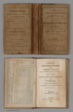
Steele, Oliver G.
Full Title
(Covers to) Steele's Western Guide Book, And Emigrant's Directory, Containing Different Routes Through The States Of New-York, Ohio, Indiana, Illinois And Michigan, With Short Descriptions Of The Climate, Soil, Productions, Prospects, &c. Fifth Edition. Greatly Improved And Enlarged. Buffalo: Published By Oliver G. Steele, 1836. (on verso) Entered ... in the year 1836 ... Press of O.G. Steele. (with) Steele's Map Of Ohio Indiana Illinois & Michigan From the Latest Authorities. Buffalo 1836. Entered ... 1835 by O.G. Steele ... Engraved by J.G. Darby, Buffalo N.Y. (inset) The Southern Part of Illinois.
Publisher
Oliver G. Steele.
Author
[Smith, J. Calvin, Colton, J.H.]
Full Title
(Covers to) Colton's Map of the States of New England And New York, With Parts Of Pennsylvania, New Jersey, The Canadas &c. Showing The Railroads, Canals, and Stage Roads With distances from place to place. Drawn by George W. Colton. Engraved by J.M Atwood N.Y. New York Published By J.H. Colton And Co. No. 172 William St. 1856. (with four inset maps). (with map) Guide Through Ohio, Michigan, Indiana, Illinois, Missouri, Wisconsin & Iowa Showing The Township lines of the United States Surveys ... by J. Calvin Smith. New York. Published by J.H. Colton. 86 Cedar St. 1853. Engraved by S.Stiles, Sherman & Smith. D. Mc. Lellan, Print. 26 Spruce St. N.Y.
Publisher
J.H. Colton
Author
Colton, J.H.
Full Title
(Covers to) Colton's Railroad & Township Map, Western States Compiled From The United States Surveys. Published by J.H. Colton No. 86 Cedar Street, New York 1854. Printed at D. Mc. Lellan's 26 Spruce St. N.Y.
Publisher
J.H. Colton
Author
Colton, J.H.
Full Title
(Covers to) Colton's Railroad & Township Map, Western States Compiled From The United States Surveys. Published by J.H. Colton and Co. No. 172 William Street, New York. 1857. J.P. Cox Sc.
Publisher
J.H. Colton & Co.
Author
[Colton, J.H., Curtiss, Daniel S.]
Full Title
(Covers to) Western Portraiture, and Emigrant's Guide: A Description of Wisconsin, Illinois, and Iowa; With remarks on Minnesota and Other Territories. By Daniel S. Curtiss. New York: Published by J.H. Colton, 86 Cedar Street. 1852. (on verso) Entered ... 1851, by J.H. Colton ... New York.
Publisher
J.H. Colton
Author
[Atwood, J.M., Ensign, Bridgman & Fanning]
Full Title
(Covers to) Ensign, Bridgman & Fanning's Traveller's Guide Through The States Of Ohio, Michigan, Indiana, Illinois, Missouri, Iowa, And Wisconsin ... Accompanied With A New Map Of The Above States. New York: Ensign, Bridgman & Fanning, 156 William Street, Corner Of Ann, 1856. (on verso) Entered ... 1855, by Ensign, Bridgman & Fanning ... New York. (with) Map Of The Western States By J.M. Atwood. Published By Ensign, Bridgman & Fanning ... 1855. Entered ... 1848 by Ensign's & Thayer ... New York.
Publisher
Ensign, Bridgman & Fanning
Author
Mitchell, Samuel Augustus
Full Title
(Covers to) A New Map Of The Western States From The Latest Authorities. Philadelphia: Published by S. Augustus Mitchell, N.E. Corner Of Market & Seventh Streets, 1846. Entered ... 1845 by S. Augustus Mitchell ... Pa. (inset) Vicinity Of The Falls Of Niagara.
Publisher
S. Augustus Mitchell
Author
[Atwood, J.M., Ensign & Thayer]
Full Title
(Covers to) Ensign & Thayer's Travellers' Guide Through The States Of Ohio, Michigan, Indiana, Illinois, Missouri, Iowa, And Wisconsin ... Accompanied With A New Map Of The Above States. New York: Published By Ensign, & Thayer & Co., 50 Ann Street, And 127 Main St., Buffalo. 1851. (on verso) Entered ... 1848, by Ensigns & Thayer ... New York. (with) Map Of The Western States by J.M. Atwood ... 1851. Published By Ensign & Thayer ... 1851. Drawn & Engraved by J.M. Atwood, N. York. Entered ... 1848 by Ensign's & Thayer ... New York.
Publisher
Ensign, Thayer & Co.
Author
Colton, G.W. & C.B.
Full Title
(Covers to) Colton's Map Of The Middle States Showing The Counties, Towns, Railroads, and Stations. Published By G.W. And C.B. Colton & Co. 172 William St. New York. 1874. Entered ... 1872 by G.W. & C.B. Colton & Co. ... Washington.
Publisher
G.W. & C.B. Colton
Author
[Smith, J. Calvin, Colton, J.H.]
Full Title
(Covers to) Guide Through Ohio, Michigan, Indiana, Illinois, Missouri, Wisconsin & Iowa. Showing the Township Lines of the United States Surveys, Location of Cities, Towns, Villages, Post Hamlets, Canals, Rail and Stage Roads. By J. Calvin Smith. New York. Published by J.H. Colton & Co. 172 William St. 1856. Entered ... 1851 by J.H. Colton ... New York. Engraved by S. Stiles, Sherman & Smith.
Publisher
J.H. Colton & Co.
Author
Asher & Company
Full Title
(Covers to) The Historical War Map. Asher & Co. Entered ... 1862, by Asher & Co. ... Indiana. E.R. Jewett & Co. Engravers, Buffalo, N.Y.
Publisher
Asher & Company
Author
Straus Brothers Company
Full Title
(Covers to) (Central States farm locations.) The Straus Bros. Co. The World's Largest Dealers in Improved Farms. ... (title on cover) Central States Map Showing location of the sections in which more than Four Hundred of the choicest and most productive farms in America are offered for sale by The Straus Brothers Company, Farm Merchants, Capital $1,000,000...Write For Catalogue.
Publisher
The Straus Brothers Company
Author
[Northern Pacific Railroad Company, Rand McNally and Company]
Full Title
(Covers to) Black Hills, Montana, Upper Missouri and Yellowstone Rivers, Northern Dakota and Minnesota, the Northern Pacific Rail Road in connection with the Northwestern Express, Stage & Transp'n Co. ... During season of navigation of 1879 ... July, 1879. Rand, McNally & Co., Printers, 77 and 79 Madison Street, Chicago.
Publisher
Rand McNally
Author
Great Northern Railway Company (U.S.)
Full Title
(Covers to) Das Red River Thal in Minnesota und Nord-Dakota. Das beste und fruchtbarste Land in America. Die Getreidekammer der Welt. Ein gutes Heim und Reichthum fur Deutsche Landwirthe.
Publisher
Great Northern Eisenbahn
Author
Chicago & Alton Railroad Company
Full Title
(Covers to) Chicago and Alton R.R. No change of cars of any class between Chicago and Kansas City ... Palace dining cars meals 75 Cents. Pullman Palace Sleeping Cars ... September, 1885. Rand, McNally & Co., Printers, Chicago.
Publisher
Rand McNally
Author
Chicago & Alton Railroad Company
Full Title
(Covers to) Chicago and Alton R.R. No change of cars of any class between Chicago and Kansas City ... Palace dining cars meals 75 Cents. Pullman Palace Sleeping Cars ... January, 1884. Rand, McNally & Co., Printers, Chicago.
Publisher
Rand McNally
Author
Lake Shore & Michigan Southern Railway
Full Title
(Covers to) Time tables and map, Lake Shore and Michigan Southern Ry. Fast express trains ... reliable through connections with eastern and New England lines, and with all express trains of the New-York Central & Hudson River Railroad, and New-York, Lake Erie & Western R.R. Only route of the Fast Mail to the Western States ... Matthews, Northrup & Co., "Morning Express" Printing House, Buffalo, N.Y.
Publisher
Matthews, Northrup & Co.
Author
Union Pacific Railroad Company
Full Title
(Covers to) World's pictorial line. Birdseye view of the Great Plains reached via the Union Pacific. The Overland Route ... Knight, Leonard & Co., Printers, Chicago.
Publisher
Knight, Leonard & Co.
Author
Louisville and Nashville Railroad Company
Full Title
(Covers to) L&N winter resorts. L&N Gulf Coast sports. Poole Bros. Chicago. (1890?)
Publisher
Poole Bros.
Author
New York Central and Hudson River Railroad Company
Full Title
(Covers to) New York Central and Hudson River Railroad. The Great 4 Track Route. (N.Y. August 14, 1885.) American Bank Note Co., N.Y.
Publisher
American Bank Note Co.
Author
Chicago and Grand Trunk Railway Company
Full Title
(Covers to) Chicago and Grand Trunk Railway in connection with the Grand Trunk R'y of Canada including Great Western Division forming the Niagara Falls Air Line. Issued June 4th, 1887 ... The J.M.W. Jones Stationery and Printing Co., Chicago, Ill.
Publisher
The J.M.W. Jones Stationery and Printing Co.
Author
[Lehigh Valley Railroad Company, Lehigh Valley Railroad]
Full Title
(Covers to) Lehigh Valley double track railroad. 2 through trains daily between New York, Philadelphia, and Buffalo, Niagara Falls, Toronto, Detroit, Chicago, St. Louis, and all points west. Hasford & Sons, N.Y. ... 9-10-85. Daily Times Print, Bethlehem, Pa.
Publisher
Rand McNally
Author
Wabash Railway Company
Full Title
(Covers to) The Wabash Railway official time tables and other information concerning the Wabash Railway. Corrected to Sept. 20, 1887 ... Rand McNally & Co., Printers and Engravers, Chicago.
Publisher
Rand McNally
Author
Pittsburgh & Western Railway Company
Full Title
(Covers to) The Pittsburgh & Western Railway Company. Lessee Pittsburgh, Cleveland & Toledo and Pittsburgh, Painesville and Fairport railroads. Time table of passenger trains, in effect August 1st, 1887. Central Standard Time ... Johnston, Print.
Publisher
Rand McNally
Author
Northern Steamship Company
Full Title
(Covers to) Northern Steamship Co. Northland. Northwest ...
Publisher
Poole Bros.
|