Who What Where WhenREMOVEWHERE
|
Author
Cram, George Franklin
Full Title
(Covers to) Cram's Standard American Atlas Of The United States, Compiled from the very latest sources, showing Railroads, Rivers, Counties, Towns, Villages, Post Offices, Population, &c., to date. A Complete Guide For Business Men. Scale, 19 Miles to an Inch. Published By George F. Cram, Proprietor Of The Western Map Depot, 66 Lake Street, Chicago, Ill. 1878.
Publisher
George F. Cram
Author
Howell, Reading
Full Title
(Covers to) A Map Of The State Of Pennsylvania. By Reading Howell MDCCXCII. To Thomas Mifflin Governor, The Senate, And House Of Representatives Of The Commonwealth Of Pennsylvania, This Map is respectfully Inscribed by the Author. Published 1 August 1792 for the Author, & Sold by James Phillips, George Yard, Lombard Street, London.
Publisher
James Phillips
Author
General de Correos Seccion de Transportes.
Full Title
Cartas Postales de los Estados Unidos Mexicanos. 1908.
Publisher
General de Correos Seccion de Transportes
Author
Mayer, Rudolf
Full Title
(Covers to and Title Page) Die Militarishchen Ereignisse im Dolferkrieg 1914-18 7ter Teil in woechentlichen Karten mit Ehronik 3u dauernder Erinnerung von der Kriegshilfe Muchen N.W. dem Kriegsfuersorgeamt Wien Ueberlassen. (Weekly Military Progress of World War I, Seventh Volume, 1914-1918 ... the War Welfare Office, Vienna).
Publisher
Der Kriegshilfe Munchen N.W (War Help)
Author
(Northwest Pub. Co.)
Full Title
(Covers to) (Decatur County, Iowa).
Publisher
Manuscript
Full Title
(Covers to) (Carte de France. Levee par ordre du Roy. 1750-1815)
Publisher
Carte de la France Directeures
Author
[Drioux, Claude-Joseph, Leroy, Charles]
Full Title
(Covers to) Atlas Universel Et Classique De Geographie Ancienne, Romaine Du Moyen Age, Moderne Et Contemporaine A L'Usage Des Etablissements D'Instruction Publique Par Mm. Drioux Et Ch. Leroy. Nouvelle Edition. Contenant Quatre-Vingt-Quatorze Cartes Et Cartons. Approuve par le Conseil superieur de perfectionnement de l'enseignement secondaire special. E.B. Paris, Librairie Classique Eugene Belin, Vve Eugene Belin & Fils, Rue De Vaugirard, No. 52. 1886.
Publisher
Eugene Belin
Author
[Buache, Philippe, 1700-1773, Lisle, Guillaume de, 1675-1726]
Full Title
(Covers to) Cartes et tables de la geographie physique ou naturelle. Presentees au Roi le 15. Mai 1757. Cet ouvrage approve et publie sous le privge. de l'Acade. du 4. Septbre 1754, se trouve a Paris, sur le Quay de l'Horloge; avec les cartes de Guill: Delisle et de Phil: Buache. Ecrit par Desbruslins, Pere.
Publisher
G. Delisle et P. Buache
Author
Kingman Brothers.
Full Title
(Covers to) Combination Atlas Map Of Miami County Indiana. Compiled, Drawn And Published From Personal Examinations And Surveys By Kingman Brothers 1877. Kingman Brothers.
Publisher
Kingman Brothers.
Author
C.S. Hammond & Company
Full Title
(Covers to) Hammond's large scale war map of the Western Front ... C.S. Hammond & Company, Incorporated Engravers, Printers, Publishers, 30 Church Street, Hudson Terminal, New York. Copyright 1917.
Publisher
C.S. Hammond
Author
[H.M. Gousha Company, Standard Oil Company of California]
Full Title
(Covers to) Street map of San Francisco. Prepared for Standard Oil Company of California ... Copyright by the H.M. Gousha Company, Chicago, San Jose. Lithographed in U.S.A. Chevron Supreme Gasoline ... (1953)
Publisher
The H.M. Gousha Company
Author
Andreas, A. T. (Alfred Theodore), 1839-1900
Full Title
(Covers to) An Illustrated Historical Atlas Of Des Moines County Iowa. Compiled, Drawn And Published From Personal Examinations And Surveys, By A.T. Andreas, Lakeside Building, Corner Clark & Adams Sts. Chicago, Ill. 1873.
Publisher
A.T. Andreas
Author
[Kartographia Winterthur, Conférence suisse des directeurs cantonaux de l'instruction publique]
Full Title
(Covers to) Atlas Scolaire Suisse pour l'Enseignement Secondaire. Publ. par la Conférence des Chefs des Départements Cant. de l'instruction publ. et Subventionné par la Confédération. 2me edition. Executé par l'Institut, Kartographia Winterthur S.A. 1921. Librairie Payot & Cie. Lausanne Geneve, 1, Rue de Bourg Pl. du Molard, 2.
Publisher
Librairie Payot
Author
[Rand McNally and Company, State Farm Insurance Companies Travel Bureau]
Full Title
(Cover Tittle to) State Farm road atlas : United States, Canada, Mexico, hotel, cabin camp guide. Published by: The State Farm Insurance Companies Travel Bureau, Bloomington, Illinois. Copyright 1939 by Rand McNally & Company, Chicago, Ill. Price $1.00 each.
Publisher
State Farm Insurance Companies Travel Bureau
Author
[Great Britain. Ordnance Survey, James, Henry, 1803-1877]
Full Title
(Covers to) Ordnance Survey. Treasury minute, dated 18 May 1855, and previous papers, relating to the Ordnance Survey. (Presented to Parliament by Her Majesty's Command.) Session 1856. (with) Report on the Ordnance Survey of the United Kingdom for 1855-56. (Signed) Henry James, Lieutenant-Colonel Royal Engineers.
Publisher
Ordnance Survey
Author
[Great Britain. Ordnance Survey, James, Henry, 1803-1877]
Full Title
(Covers to) Extension of the triangulation of the Ordnance Survey into France and Belgium :with the measurement of an Arc of parallel in latitude 52(degree) N. from Valentia in Ireland to Mount Kemmel in Belgium. Published by order of the right Hon. Sir George C, Lewis, Bart. Secretary of State for war. By Colonel Sir Henry James, R.E., F.R.s., &c. Director of the Ordnance Survey. London : Printed by George Edward Eyre and William Spottiswoode, Printed to the Queen's most excellent Majesty. for the Majesty's Stationary Office. 1863.
Publisher
George Edward Eyre and William Spottiswoode
Author
[Great Britain. Ordnance Survey, James, Henry, 1803-1877]
Full Title
(Text page to) To Colonel James : Respectfully offered by the author T.F. de Schubert. Sur l'Influence des attractions locales dans les Operations Geodesiques et particulierement dans l'Arc Scandinavo - Russe. Par Le General de l'Infantierie T.F. de Schubert, Member de l'academie des Sciences de St. Petersbourg. Altona, 1860. (to accompany) Extension of the triangulation of the Ordnance Survey into France and Belgium ... 1863.
Publisher
George Edward Eyre and William Spottiswoode
Author
Mayer, Rudolf
Full Title
(Covers to and Title Page) Die Militarishchen Ereignisse im Dolferkrieg 1914-15 1ter Teil in woechentlichen Karten mit Ehronik 3u dauernder Erinnerung von der Kriegshilfe Muchen N.W. dem Kriegsfuersorgeamt Wien Ueberlassen. (Weekly Military Progress of World War I, First Volume, 1914-1915 ... the War Welfare Office, Vienna).
Publisher
Der Kriegshilfe Munchen N.W (War Help)
Author
Mayer, Rudolf
Full Title
(Covers to and Title Page) Die Militarishchen Ereignisse im Dolferkrieg 1914-15 2ter Teil in woechentlichen Karten mit Ehronik 3u dauernder Erinnerung von der Kriegshilfe Muchen N.W. dem Kriegsfuersorgeamt Wien Ueberlassen. (Weekly Military Progress of World War I, Second Volume, 1914-1915 ... the War Welfare Office, Vienna).
Publisher
Der Kriegshilfe Munchen N.W (War Help)
Author
Mayer, Rudolf
Full Title
(Covers to and Title Page) Die Militarishchen Ereignisse im Dolferkrieg 1914-16 2ter Teil in woechentlichen Karten mit Ehronik 3u dauernder Erinnerung von der Kriegshilfe Muchen N.W. dem Kriegsfuersorgeamt Wien Ueberlassen. (Weekly Military Progress of World War I, Third Volume, 1914-1916 ... the War Welfare Office, Vienna).
Publisher
Der Kriegshilfe Munchen N.W (War Help)
Author
Mayer, Rudolf
Full Title
(Covers to and Title Page) Die Militarishchen Ereignisse im Dolferkrieg 1914-16 4ter Teil in woechentlichen Karten mit Ehronik 3u dauernder Erinnerung von der Kriegshilfe Muchen N.W. dem Kriegsfuersorgeamt Wien Ueberlassen. (Weekly Military Progress of World War I, Fourth Volume, 1914-1916 ... the War Welfare Office, Vienna).
Publisher
Der Kriegshilfe Munchen N.W (War Help)
Author
Mayer, Rudolf
Full Title
(Covers to and Title Page) Die Militarishchen Ereignisse im Dolferkrieg 1914-17 5ter Teil in woechentlichen Karten mit Ehronik 3u dauernder Erinnerung von der Kriegshilfe Muchen N.W. dem Kriegsfuersorgeamt Wien Ueberlassen. (Weekly Military Progress of World War I, Fifth Volume, 1914-1917 ... the War Welfare Office, Vienna).
Publisher
Der Kriegshilfe Munchen N.W (War Help)
Author
Mayer, Rudolf
Full Title
(Covers to and Title Page) Die Militarishchen Ereignisse im Dolferkrieg 1914-18 6ter Teil in woechentlichen Karten mit Ehronik 3u dauernder Erinnerung von der Kriegshilfe Muchen N.W. dem Kriegsfuersorgeamt Wien Ueberlassen. (Weekly Military Progress of World War I, Sixth Volume, 1914-1918 ... the War Welfare Office, Vienna).
Publisher
Der Kriegshilfe Munchen N.W (War Help)
Author
Beers, J.H. & Co.
Full Title
(Covers to) Atlas of Franklin Co. Indiana. To Which Are Added Various General Maps History, Statistics, Illustrations. &c. &c. &c. J.H. Beers & Co. Publishers, Lakeside Building Cor. of Clark & Adams Sts. Chicago. 1882.
Publisher
J.H. Beers
Author
Pinkney & Brown
Full Title
(Covers to) Plat Book Of Saint Croix County Wisconsin. Compiled From Official Records And Actual Surveys, Published By Pinkney & Brown, 1897. Eng. by Balliet & Volk, 27 So. Sixth St. Phila. Printed by F. Bourquin, 31 So. 6th St. Philad.
Publisher
F. Bourquin
Author
[Hardesty, L.Q., Hardesty, H.H.]
Full Title
(Covers to) Illustrated Historical Atlas Of Ottawa County, Ohio. From Recent and Actual Surveys and Records, Under The Superintendence Of L.Q. Hardesty, C.E. Chicago, Illinois: Published by H.H. Hardesty. 1874. Printed At The Lakeside Press, Clark And Adams Streets, Chicago.
Publisher
H.H. Hardesty
Author
[Butler, Lowell, Newbro, William H., Robinson, William W.]
Full Title
(Covers to) A map of the missions, presidios, pueblos, and some of the more interesting ranchos of Spanish California : together with the routes of the principal land explorations therein. Published by Westways. (copyright) 1956 by the Automobile Club of Southern California. (on opposite page) A note of Explanation (by) Phil Townsend Hanna
Publisher
[Westways, Automobile Club of Southern California]
Author
[Butler, Lowell, Webb, William, Hanna, Phil Townsend, 1896-1957]
Full Title
(Covers to) Outdoor play places of California : a cartographic map of some of the outstanding recreational areas of the Golden State : Published by Westways ; Copyright 1954 by the Automobile Club of Southern California. (on opposite page) A note of Explanation (by) Phil Townsend Hanna.
Publisher
[Westways, Automobile Club of Southern California]
Author
[Butler, Lowell, Webb, William, Hanna, Phil Townsend, 1896-1957]
Full Title
(Covers to) A Map of the Marked Historical Sites of California : Compiled from the official registrations of the California State Department of Natural Resources: Published by Westways ; Copyright 1952 by the Automobile Club of Southern California. (on opposite page) A note of Explanation (by) Phil Townsend Hanna.
Publisher
[Westways, Automobile Club of Southern California]
Author
Higgins, Belden & Co.
Full Title
(Covers to) An Illustrated Historical Atlas Of Elkhart Co. Indiana. Compiled Drawn & Published from Personal Examinations & Surveys by Higgins, Belden & Co. Lakeside Building Corner Clark & Adams Sts. Chicago 1874.
Publisher
Higgins, Belden & Co.
Author
Cram, George Franklin
Full Title
(Covers to) New Rail Road & township map of Missouri and Kansas : Published by Geo. F. Cram & Co. Western Map Depot. 148 Lake Street, Chicago Ills.
Publisher
Geo. F. Cram & Co.
Author
Wyld, James, 1812-1887
Full Title
(Covers to) Mexico The British Possessions In North America And The United States. London. Published By Jas. Wyld, Geographer To The Queen, Charing Cross East. 1846. James Wyld, Geographer to the Queen and to H.R.H. Prince Albert, Charing Cross, East, four doors from Trafalgar Square, London ... (inset) North America. (inset) Islands in the Pacific Ocean.
Publisher
James Wyld
Author
[Randall, Neil, Downs, Timothy Edwards]
Full Title
(Covers to) Road Map to the Best Free Stuff on the Interest.
Publisher
P.C. Computing
Author
[U.S. Army Corps of Engineers, Moser, C.]
Full Title
(Covers to) Map Of The Ohio River, Reduced from the following surveys ... 1837-8, Lieut. Sanders ... 1844, C.A. Fuller ... 1867-8, W.M. Roberts ... With additions & corrections from later surveys. Made under the direction of Major W.E. Merrill, Corps of Engineers, By C. Moser ...
Publisher
Corps of Engineers
Author
Cummins Map Co.
Full Title
(Covers to) Atlas Of Province Of Prince Edward Island Canada And The World. Published by Cummins Map Co. M.S. Arniel, Manager. 70 Lombard Street, Toronto, Ont. Copyrighted. (Bound with) The New International Atlas Of The World ... Profusely Illustrated By George Wharton James and Alan H. Burgoyne ... And Elmore Elliott Peake ... Publishers Cummins Map Co. ...
Publisher
Cummins Map Co.
Author
[Roe, F.B., Colby, N. Geo.]
Full Title
(Covers to) Atlas Of Aroostook County Maine. Compiled and Drawn From Official Plans and Actual Surveys By F.B. Roe & N. Geo. Colby. Published By Roe & Colby, 27 South 6th St. Philadelphia, Pa. 1877. Engd. by Worley & Bracher, 27 South Sixth St. Philada. F. Bourquin's Steam Lighographic Press, 31 South 6th St. Philada.
Publisher
Roe & Colby
Author
[Hardy, M. Georges, Pollacchi, P., de Flotte de Roquevaire, M.R., Mady, H.]
Full Title
(Covers to) Atlas de L'Afrique du Nord. Preface de M. Max Sorre, Directeur de l'Enseignement du 1er Degre et de l'Education postscolaire au ministere de l'Education nationale. Texte de M. Georges Hardy, Recteur de l'Academie de Lille. Cartes dressees par: le Commandant P. Pollacchi, Ancien chef de la Cartographie etrangere du Service Geographique de l'Armee; M.R. de Flotte de Roquevaire, Chef du Service Cartographhique du Gouvernement, General de l'Algerie; le Commandant H. Nady, Chef de Service Geographique du Maroc. L'Illustration, 13, rue Saint-Georges, Paris, 1939.
Publisher
L'Illustration
Author
[Taylor, Frank J., White, Ruth Taylor]
Full Title
(Covers to) Our U.S.A. A Gay Geography. Text by Frank J. Taylor. Maps by Ruth Taylor. Boston - Little, Brown, and Company - 1935.
Publisher
Little, Brown, and Company
Author
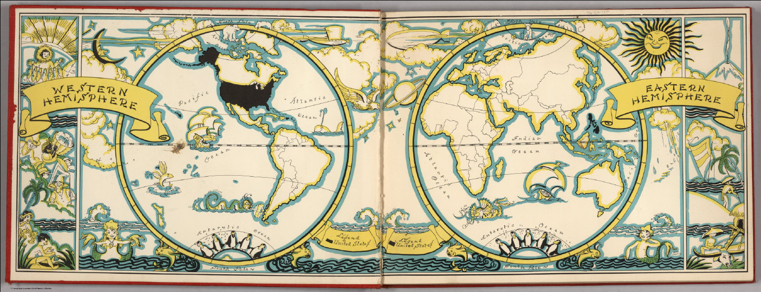
[Taylor, Frank J., White, Ruth Taylor]
Full Title
(Liners of Front and Back Covers) (The Earth in Hemispheres).
Publisher
Little, Brown, and Company
Author
North West Publishing Co.
Full Title
(Covers to) Plat Book Of Jasper County Missouri. Drawn From Actual Surveys & County Records By The North West Publishing Co. 1895. Eng. by Balliet & Volk, 27 So. Sixth St. Phila. Printed by F. Bourquin, 31 So. 6th St. Philad.
Publisher
North West Publishing Co.
Author
American Atlas Company
Full Title
(Covers to) Atlas And Directory Of Trumbull County, Ohio. Including A Directory Of Freeholders And Official Register Of The County. With Illustrations. Compiled from Recent Surveys, Official Records and Personal Examination by The American Atlas Company, Cleveland, Ohio. 1899.
Publisher
American Atlas Company
Author
Bien, Joseph Rudolf
Full Title
(Covers to) Atlas of the state of New York. Prepared under the direction of Joseph R. Bien, E.M., civil and topographical engineer from original surveys and various local surveys revised and corrected. Published by Julius Bien & Company, New York, 1895.
Publisher
Julius Bien & Co.
Author
Gill, Leslie MacDonald, 1884-1947
Full Title
(Covers to) Underground : What to see & how to travel. Map of the electric railways of London. Electric Railway House, Broadway, Westminster, S.W. "1,000,000 9-3-21." (on verso) Underground : Map of the electric railways of London. MacDonald Gill 1920. the Dangerfield Printing Co. LTD., London.
Publisher
The Dangerfield Printing Co.
Author
Chase, Ernest Dudley, 1878-1966
Full Title
(Covers to) A world of fun and relaxation, Massachusetts, the historic vacationland : a travel map to help you feel at home in the Bay State. "Form 97-150M-7-57-920616 Publication of the document approved by George J. Cronin, Staff purchasing agent". (on verso) Historic Massachusetts : a travel map to help you feel at home in the Bay State. Massachusetts. Department of Commerce, 334 Boylston St. Boston, 16 Mass. Designed and drawn by Ernest Dudley Chase.
Publisher
Dept. of Commerce
Author
Forest Lawn Memorial-Park Association
Full Title
(Covers to) Pictorial map of Forest Lawn Memorial-Park, Glendale, California. Copyrighted 1945 by Forest Lawn Memorial-Park Assn., Inc. (on verso) Pictorial map of Forest Lawn Memorial - Park, showing the location of interment sections, buildings and art treasures.
Publisher
Forest Lawn Assn., Inc.
Author
Rand McNally & Company
Full Title
(Covers to) Map of the USA and the Baltimore & Ohio Railroad System. B & O.
Publisher
Rand McNally & Company
Author
Forest Lawn Memorial-Park
Full Title
(Covers to) Pictorial Map and Visitor's Guide to Forest Lawn Memorial-Park, Glendale, California.
Publisher
Forest Lawn Memorial-Park
Author
Andriveau-Goujon, J.
Full Title
(Covers to) Atlas classique et universel de geographie ancienne et moderne, contenant les decouvertes et les divisions les plus nouvelles dans les cinq parties du monde pour servir a la lecture des voyages, des ouvrages historiques et des meilleurs traites de geographie. Publie par J. Andriveau-Goujon. Adopte par le Ministre de la Guerre pour les bibliotheques regimentaires. Nouvelle edition. A Paris, Chez l'Editeur, Rue du Bac, no. 21, pres le Pont Royal. 1850.
Publisher
J. Andriveau-Goujon
Author
Bollmann, Hermann (1911-1971)
Full Title
(Covers to) New York (City) Map-Guide. Picture Map in Full Color.
Publisher
Pictorial Maps, Inc.
|