|
|
Author
Duflot de Mofras, Eugene
Full Title
(Covers to) Exploration Du Territoire De L'Oregon, Des Californies Et De La Mer Vermeille, Executee Pendant Les Annees 1840, 1841 Et 1842, Par M. Duflot De Mofras, Attache A La Legation De France A Mexico. Ouvrage Publie Par Ordre Du Roi, Sous Les Auspices De M. Le Marechal Soult, Duc De Dalmatie, President du Conseil, Et De M. Le Ministre Des Affaires Etrangeres. Tome Premier. Paris, Arthus Bertrand, Editeur, Libraire De La Societe De Geographie, Rue Hautefeuille, No. 23. 1844. Paris. - Typographie de Firmin Didot Freres, rue Jacob, 56 ... Tome Second ... Atlas (with map) Carte De La Cote De L'Amerique Sur L'Ocean Pacifique Septentrional comprenant Le Territoire De L'Oregon, Les Californies, La Mer Vermeille ...
Publisher
Arthus Bertrand
Author
Duflot de Mofras, Eugene
Full Title
(Half Title Page to) Exploration Du Territoire De L'Oregon, Des Californies Et De La Mer Vermeille, Executee Pendant Les Annees 1840, 1841 Et 1842, Par M. Duflot De Mofras, Attache A La Legation De France A Mexico. Ouvrage Publie Par Ordre Du Roi, Sous Les Auspices De M. Le Marechal Soult, Duc De Dalmatie, President du Conseil, Et De M. Le Ministre Des Affaires Etrangeres. Tome Premier. Paris, Arthus Bertrand, Editeur, Libraire De La Societe De Geographie, Rue Hautefeuille, No. 23. 1844. Paris. - Typographie de Firmin Didot Freres, rue Jacob, 56 ... Tome Second ... Atlas (with map) Carte De La Cote De L'Amerique Sur L'Ocean Pacifique Septentrional comprenant Le Territoire De L'Oregon, Les Californies, La Mer Vermeille ...
Publisher
Arthus Bertrand
Author
Duflot de Mofras, Eugene
Full Title
(Title Page to) Exploration Du Territoire De L'Oregon, Des Californies Et De La Mer Vermeille, Executee Pendant Les Annees 1840, 1841 Et 1842, Par M. Duflot De Mofras, Attache A La Legation De France A Mexico. Ouvrage Publie Par Ordre Du Roi, Sous Les Auspices De M. Le Marechal Soult, Duc De Dalmatie, President du Conseil, Et De M. Le Ministre Des Affaires Etrangeres. Tome Premier. Paris, Arthus Bertrand, Editeur, Libraire De La Societe De Geographie, Rue Hautefeuille, No. 23. 1844. Paris. - Typographie de Firmin Didot Freres, rue Jacob, 56 ... Tome Second ... Atlas (with map) Carte De La Cote De L'Amerique Sur L'Ocean Pacifique Septentrional comprenant Le Territoire De L'Oregon, Les Californies, La Mer Vermeille ...
Publisher
Arthus Bertrand
Author
Duflot de Mofras, Eugene
Full Title
(Index to) Exploration Du Territoire De L'Oregon, Des Californies Et De La Mer Vermeille, Executee Pendant Les Annees 1840, 1841 Et 1842, Par M. Duflot De Mofras, Attache A La Legation De France A Mexico. Ouvrage Publie Par Ordre Du Roi, Sous Les Auspices De M. Le Marechal Soult, Duc De Dalmatie, President du Conseil, Et De M. Le Ministre Des Affaires Etrangeres. Tome Premier. Paris, Arthus Bertrand, Editeur, Libraire De La Societe De Geographie, Rue Hautefeuille, No. 23. 1844. Paris. - Typographie de Firmin Didot Freres, rue Jacob, 56 ... Tome Second ... Atlas (with map) Carte De La Cote De L'Amerique Sur L'Ocean Pacifique Septentrional comprenant Le Territoire De L'Oregon, Les Californies, La Mer Vermeille ...
Publisher
Arthus Bertrand
Author
Duflot de Mofras, Eugene
Full Title
Carte De La Cote De L'Amerique Sur L'Ocean Pacifique Septentrional Le Territoire De L'Oregon, Les Californies, La Mer Vermeille, Partie des Territoires de la Compagnie de la Baie d'Hudson, Et De L'Amerique Russe. Dressee par Mr. Duflot de Mofras, Attache a la Legation de France a Mexico; Pour servir a l'intelligence de son Voyage d'exploration Publie Par Ordre Du Roi, sous les Auspices De Mr. Le Marechal Duc De Dalmatie, Mr. Le Ministre Des Affaires Etrangeres. Paris, 1844. Le plan grave par Jacobs. L'ecriture gravee par Hacq. Publie par Arthus Bertrand.
Publisher
Arthus Bertrand
Author
Duflot de Mofras, Eugene
Full Title
Plan De L'Embouchure Du Rio Colorado dans la Mer Vermeille. No. 10. (with) Plan Du Port De S. Diego situe sur la cote septentrionale De La Californie. No. 11. Publie Par Arthus Bertrand. Voyage de Mr. Duflot de Mofras.
Publisher
Arthus Bertrand
Author
Duflot de Mofras, Eugene
Full Title
Mouillage De San Pedro. No. 12. (with) Mouillage De La Mission De Sta. Barbara. No. 13. Publie Par Arthus Bertrand. Voyage de Mr. Duflot de Mofras.
Publisher
Arthus Bertrand
Author
Duflot de Mofras, Eugene
Full Title
Plan du Port Et De La Baie De Monte-Rey situes sur la Cote Septle. de la Californie. No. 14. (with) Baie De La Trinidad. No. 15. Publie Par Arthus Bertrand. Voyage de Mr. Duflot de Mofras.
Publisher
Arthus Bertrand
Author
Duflot de Mofras, Eugene
Full Title
Port De San Francisco Dans La Haute Californie. No. 16. (with) Entree Du Port De San Francisco et des mouillages del Sausalito et de la Yerba Buena. Publie Par Arthus Bertrand. Grave par S. Jacobs. Voyage de Mr. Duflot de Mofras.
Publisher
Arthus Bertrand
Author
Duflot de Mofras, Eugene
Full Title
Carte Detaillee Du Mouillage Du Fort Ross et du Port De La Bodega ou Romanzoff dans la Nouvelle Californie, occupes par les Russes. No. 17. Publie Par Arthus Bertrand. Voyage de Mr. Duflot de Mofras.
Publisher
Arthus Bertrand
Author
Duflot de Mofras, Eugene
Full Title
Vue De La Mission De Saint Louis Roi De France dans la Nouvelle Californie. No. 23 de l'Atlas. Publie Par Arthus Bertrand. Imp. par Lemercier. Lith par Muller. Voyage de Mr. Duflot de Mofras.
Publisher
Arthus Bertrand
Author
Duflot de Mofras, Eugene
Full Title
Plan Geometrique De La Mission De St. Louis Roi De France. Dans la Nouvelle Californie. No. 24 de l'Atlas. Paris Arthus Bertrand, Editeur. Grave sur pierre par Ch. Avril. Lith. de Bineteau. Voyage de Mr. Duflot de Mofras.
Publisher
Arthus Bertrand
Author
Duflot de Mofras, Eugene
Full Title
Tete De Chef Indien De La Cote Nord Ouest De L'Amerique. Armes et ustensiles des Indiens de la Nouvelle Californie. No. 25 de l'Atlas. Publie par Arthus Bertrand. Imp. par Lemercier. Lith. par Muller. Voyage de Mr. Duflot de Mofras.
Publisher
Arthus Bertrand
Author
Emory, William H.
Full Title
(Title Page to) Notes of a Military Reconnoissance, From Fort Leavenworth, In Missouri, To San Diego, In California, Including Part of the Arkansas, Del Norte, and Gila Rivers. By W.H. Emory, Brevet Major, Corps Topographical Engineers. Made in 1846-7, with the Advanced Guard of the "Army of the West." Washington: Wendell and van Benthuysen, Printers. 1848. [Senate] 30th Congress, 1st Session. Executive, No. 7.
Publisher
Wendell and Van Benthuysen
Author
Emory, William H.
Full Title
Military Reconnaissance Of The Arkansas Rio Del Norte And Rio Gila By W.H. Emory, Lieut. Top. Engrs. Assisted ... by J.W. Abert and W.G. Peck, and ... by W.H. Warner and Mr. Norman Bestor, Made in 1846-7, with the advance guard of the "Army of the West". Under Command Of Brig. Gen. Stephn. W. Kearny. Constructed under the orders of Col. J.J. Abert ... 1847. Drawn by Joseph Welch. Engraved on stone by E. Weber & Co. Baltimore.
Publisher
Wendell and Van Benthuysen
Author
Fremont, J.C.
Full Title
(Title Page to) Report of The Exploring Expedition to The Rocky Mountains in the Year 1842, and to Oregon and North California in the Years 1843-'44.
Publisher
Blair and Rives
Author
Fremont, J.C.
Full Title
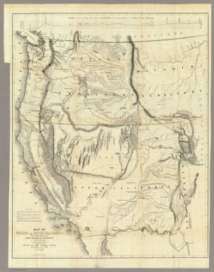
Map Of An Exploring Expedition To The Rocky Mountains in the Year 1842, Oregon & North California In The Years 1843-44. By Brevet Capt. J. C. Fremont Of The Corps Of Topographical Engineers Under the orders of Col. J.J. Abert, Chief Of The Topographical Bureau. Lith. by E. Weber & Co. Baltimore, Md.
Publisher
Blair and Rives
Author
Fremont, J.C.
Full Title
(Title Page to) Geographical Memoir upon Upper California In Illustration of His Map of Oregon and California, by John Charles Fremont: Addressed to the Senate of the United States. Washington: Wendell and Van Benthuysen, Printers. 1848. [Senate.] 30th Congress, 1st Session. Miscellaneous. No. 148.
Publisher
Wendell and Van Benthuysen
Author
Fremont, J.C.
Full Title
Map Of Oregon And Upper California From the Surveys of John Charles Fremont And other Authorities. Drawn By Charles Preuss Under the Order of the Senate Of The United States, Washington City 1848. Lithy. by E. Weber & Co. Balto. (inset) Profile of the travelling route from the South Pass of the Rocky Mountains to the Bay of San Francisco.
Publisher
Wendell and Van Benthuysen
Author
[Ives, J.C., Mollhausen, H. B., Young, J. J.]
Full Title
Chimney Peak. Colorado Exploring Expedition frontispiece. J.J. Young from a sketch by H.B. Mollhausen. Lith. of Sarony, Major & Knapp, 449 Broadway, N.Y. In Charge. (Washington: Government Printing Office. 1861. Senate. 36th Congress, 1st Session. Ex. Doc.)
Publisher
U.S.
Author
Ives, J.C.
Full Title
Colorado River. Chemehuevis Valley, From Monument Mountains to Mojave Mountains. Colorado Exploring Expedition. Panoramic View No. 1. Drawn by Frhr. F.W. v. Ecloffstein.
Publisher
U.S.
Author
Ives, J.C.
Full Title
Fig 1. - Yuma Shoals.
Publisher
U.S.
Author
Ives, J.C.
Full Title
Fig 2. - Explorer's Pass.
Publisher
U.S.
Author
Ives, J.C.
Full Title
Fig 3. - Purple Hills.
Publisher
U.S.
Author
Ives, J.C.
Full Title
Cane Brake Canyon, from near Camp 16. Colorado Exploring Expedition. General Report - Plate II. J.J. Young from a sketch by F.W. Egloffstein. Lith Sarony, Major & Knapp, 449 Broadway N.Y.
Publisher
U.S.
Author
Ives, J.C.
Full Title
Fig 4. - Purple Hills Pass.
Publisher
U.S.
Author
Ives, J.C.
Full Title
Fig 5. - Red Rock Gate.
Publisher
U.S.
Author
Ives, J.C.
Full Title
Fig 6. - Sleeper's Bend.
Publisher
U.S.
Author
Ives, J.C.
Full Title
Fig 7. - Light-house Rock.
Publisher
U.S.
Author
Ives, J.C.
Full Title
Fig 8. - Riverside Mountains.
Publisher
U.S.
Author
Ives, J.C.
Full Title
Chemehuevis. Colorado Exploring Expedition. Indian Portraits, Plate III. B. Mollhausen, Del. Lith. of Sarony, Major & Knapp, 449 Broadway N.Y.
Publisher
U.S.
Author
Ives, J.C.
Full Title
Fig 9. - Monument Mountains.
Publisher
U.S.
Author
Ives, J.C.
Full Title
Fig 10. - Corner Rock.
Publisher
U.S.
Author
Ives, J.C.
Full Title
Fig 11. - Monument Canyon.
Publisher
U.S.
Author
Ives, J.C.
Full Title
Fig 12. - Monument Range from the North.
Publisher
U.S.
Author
Ives, J.C.
Full Title
Fig 13. - Mount Whipple.
Publisher
U.S.
Author
Ives, J.C.
Full Title
Fig 14. - Remains of Grand Mesa in Chemehuevis Valley.
Publisher
U.S.
Author
Ives, J.C.
Full Title
Mojave Canon. Colorado Exploring Expedition. General Report, Plate III. J.J. Young from a sketch by H.B. Mollhausen, Del.
Publisher
U.S.
Author
Ives, J.C.
Full Title
Fig 15. - Mouth of Mojave Canon.
Publisher
U.S.
Author
Ives, J.C.
Full Title
Colorado River. Mojave Valley, From Mojave Mountains to Pyramid Canon. Colorado Exploring Expedition. Panoramic View No. 2. Drawn by Frhr. F.W. v. Ecloffstein. Lith. of Sarony Major & Knapp, 449 Broadway N.Y.
Publisher
U.S.
Author
Ives, J.C.
Full Title
Fig 16. - Head of Mojave Canon.
Publisher
U.S.
Author
Ives, J.C.
Full Title
Fig 1. Chimney Peak from the North.
Publisher
U.S.
Author
Ives, J.C.
Full Title
Fig 2. Spire Range.
Publisher
U.S.
Author
Ives, J.C.
Full Title
The Needles (Mojave Range). Colorado Exploring Expedition. Geology, Plate II. J.J. Young from a sketch by H.B. Mollhausen. Lith. of Sarcony, Major & Knapp, 449 Broadway N.Y.
Publisher
U.S.
Author
Ives, J.C.
Full Title
Fig 10. Section of Trough of Colorado at Elephant Hill.
Publisher
U.S.
Author
La Perouse, Jean-Francois de Galaup, comte de, 1741-1788
Full Title
Chart of Part of the North West Coast of America Explored by the Boussole & Astrolabe laid down conformally to the position of the Boussole every day at noon as determinined Astronomically by Mr. Dagelet. Published as the Act directs Novr. 1st 1798, by G.G. & J. Robinson, Paternoster Row. S. Neele, sculpt, Strand. No. 16.
Publisher
G.G. & J. Robinson.
Author
La Perouse, Jean-Francois de Galaup, comte de, 1741-1788
Full Title
Chart of the North West Coast of America. Explored by the Boussole & Astrolabe in 1786. 3d. Sheet. Published as the Act directs Novr. 1st 1798, by G.G. & J. Robinson, Paternoster Row, London. No. 31.
Publisher
G.G. & J. Robinson.
Author
La Perouse, Jean-Francois de Galaup, comte de, 1741-1788
Full Title
Plan of the Port of St. Francisco in California. Point de Reyes in 37 degrees 59 minutes of Latitude North & 124 degrees, 54 minutes Longitude - West. Published as the Act directs Novr. 1st 1798, by G.G. & J. Robinson, Paternoster Row, London. Neele, sculpt., Strand. No. 33.
Publisher
G.G. & J. Robinson.
Author
La Perouse, Jean-Francois de Galaup, comte de, 1741-1788
Full Title
Plan of the Bay of Monterey, Situate in North California, in 36 degrees 38 minutes of Latitude North & 124 degrees, 3 minutes Longitude - West, to Illustrate the Voyage of La Perouse. Published as the Act directs Novr. 1st 1798, by G.G. & J. Robinson, Pater-noster Row, London. S. Neele, sculpt., Strand. No. 34.
Publisher
G.G. & J. Robinson.
Author
La Perouse, Jean-Francois de Galaup, comte de, 1741-1788
Full Title
(Two charts) Plan of the Port of S. Diego in California. Situate in in 32 degrees 39 minutes 0 seconds of Latitude North & 12 degrees, 4 minutes 0 seconds West of St. Blas from a Survey in 1782 .... Plan of the Port and Department of S. Blas, Situate 21 degrees 30 minutes of Latitude Nth. & 88 degrees 15 minutes 0 seconds _ West of Tenefriffe and 107 degrees 15 minutes 0 seconds _ West of Paris from a Survey in november 1877. Published as the Act directs Novr. 1st 1798, by G.G. & J. Robinson, Paternoster Row, London. S. Neele, sculpt., Strand. No. 35.
Publisher
G.G. & J. Robinson.
|