Browse All

1844 Cover: Exploration du Territoire de L'Or … Exploration Book (Covers to) Exploration Du Territoire De … |

1844 Half Title: Exploration du Territoire de … Exploration Book (Half Title Page to) Exploration Du Terr … |

1844 Title Page: Exploration du Territoire de … Exploration Book (Title Page to) Exploration Du Territoir … |

1844 Index: Exploration du Territoire de l'Or … Exploration Book (Index to) Exploration Du Territoire De … |

1844 Carte De La Cote De L'Amerique. Exploration Book Carte De La Cote De L'Amerique Sur L'Oce … |

1844 Plan De L'Embouchure Du Rio Colorado. Exploration Book Plan De L'Embouchure Du Rio Colorado dan … |

1844 Mouillage De San Pedro. No. 12. (with) M … Exploration Book Mouillage De San Pedro. No. 12. (with) M … |

1844 Plan du Port Et De La Baie De Monte-Rey. Exploration Book Plan du Port Et De La Baie De Monte-Rey … |

1844 Port De San Francisco Dans La Haute Cali … Exploration Book Port De San Francisco Dans La Haute Cali … |

1844 Carte Detaillee Du Mouillage Du Fort Ros … Exploration Book Carte Detaillee Du Mouillage Du Fort Ros … |

1844 Vue De La Mission De Saint Louis. Exploration Book Vue De La Mission De Saint Louis Roi De … |

1844 Plan Geometrique De La Mission De St. Lo … Exploration Book Plan Geometrique De La Mission De St. Lo … |

1844 Tete De Chef Indien De La Cote Nord Oues … Exploration Book Tete De Chef Indien De La Cote Nord Oues … |

1848 Title Page: Notes of a military reconnoi … Exploration Book (Title Page to) Notes of a Military Reco … |

1848 Military Reconnaissance Of The Arkansas … Exploration Book Military Reconnaissance Of The Arkansas … |

1845 Title Page: Report of the Exploring Expe … Exploration Book (Title Page to) Report of The Exploring … |

1845 Map Of An Exploring Expedition To The Ro … Exploration Book Map Of An Exploring Expedition To The Ro … |

1848 Title Page: Geographical memoir upon Upp … Exploration Book (Title Page to) Geographical Memoir upon … |
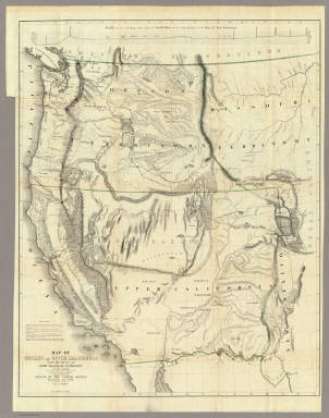
1848 Map Of Oregon And Upper California. Exploration Book Map Of Oregon And Upper California From … |

1861 Chimney Peak. Exploration Book Chimney Peak. Colorado Exploring Expedit … |

1861 Colorado River. Chemehuevis Valley, From … Exploration Book Colorado River. Chemehuevis Valley, From … |

1861 Yuma Shoals. Exploration Book Fig 1. - Yuma Shoals. |

1861 Explorer's Pass. Exploration Book Fig 2. - Explorer's Pass. |

1861 Purple Hills. Exploration Book Fig 3. - Purple Hills. |

1861 Cane Brake Canon, from near Camp 16. Exploration Book Cane Brake Canyon, from near Camp 16. Co … |

1861 Purple Hills Pass. Exploration Book Fig 4. - Purple Hills Pass. |

1861 Red Rock Gate. Exploration Book Fig 5. - Red Rock Gate. |

1861 Sleeper's Bend. Exploration Book Fig 6. - Sleeper's Bend. |

1861 Light-house Rock. Exploration Book Fig 7. - Light-house Rock. |

1861 Riverside Mountains. Exploration Book Fig 8. - Riverside Mountains. |

1861 Chemehuevis. Exploration Book Chemehuevis. Colorado Exploring Expediti … |

1861 Monument Mountains. Exploration Book Fig 9. - Monument Mountains. |

1861 Corner Rock. Exploration Book Fig 10. - Corner Rock. |

1861 Monument Canyon. Exploration Book Fig 11. - Monument Canyon. |

1861 Monument Range from the North. Exploration Book Fig 12. - Monument Range from the North. |

1861 Mount Whipple. Exploration Book Fig 13. - Mount Whipple. |

1861 Remains of Grand Mesa in Chemehuevis Val … Exploration Book Fig 14. - Remains of Grand Mesa in Cheme … |

1861 Mojave Canon. Exploration Book Mojave Canon. Colorado Exploring Expedit … |

1861 Mouth of Mojave Canon. Exploration Book Fig 15. - Mouth of Mojave Canon. |

1861 Colorado River. Mojave Valley, From Moja … Exploration Book Colorado River. Mojave Valley, From Moja … |

1861 Head of Mojave Canon. Exploration Book Fig 16. - Head of Mojave Canon. |

1861 Chimney Peak from the North. Exploration Book Fig 1. Chimney Peak from the North. |

1861 Spire Range. Exploration Book Fig 2. Spire Range. |

1861 The Needles (Mojave Range). Exploration Book The Needles (Mojave Range). Colorado Exp … |

1861 Section of Trough of Colorado at Elephan … Exploration Book Fig 10. Section of Trough of Colorado at … |

1799 Chart of Part of the North West Coast of … Exploration Book Chart of Part of the North West Coast of … |

1799 Chart of the North West Coast of America … Exploration Book Chart of the North West Coast of America … |

1799 Port of San Francisco. Exploration Book Plan of the Port of St. Francisco in Cal … |

1799 Bay of Monterey. Exploration Book Plan of the Bay of Monterey, Situate in … |

1799 Port of San Diego; Port of San Blas. Exploration Book (Two charts) Plan of the Port of S. Dieg … |