Who What Where WhenREMOVEWHO
|
REFINE
Browse All : Exploration Book of Mexico
1-45 of 45
Author
Duflot de Mofras, Eugene
Full Title
(Covers to) Exploration Du Territoire De L'Oregon, Des Californies Et De La Mer Vermeille, Executee Pendant Les Annees 1840, 1841 Et 1842, Par M. Duflot De Mofras, Attache A La Legation De France A Mexico. Ouvrage Publie Par Ordre Du Roi, Sous Les Auspices De M. Le Marechal Soult, Duc De Dalmatie, President du Conseil, Et De M. Le Ministre Des Affaires Etrangeres. Tome Premier. Paris, Arthus Bertrand, Editeur, Libraire De La Societe De Geographie, Rue Hautefeuille, No. 23. 1844. Paris. - Typographie de Firmin Didot Freres, rue Jacob, 56 ... Tome Second ... Atlas (with map) Carte De La Cote De L'Amerique Sur L'Ocean Pacifique Septentrional comprenant Le Territoire De L'Oregon, Les Californies, La Mer Vermeille ...
Publisher
Arthus Bertrand
Author
Duflot de Mofras, Eugene
Full Title
(Half Title Page to) Exploration Du Territoire De L'Oregon, Des Californies Et De La Mer Vermeille, Executee Pendant Les Annees 1840, 1841 Et 1842, Par M. Duflot De Mofras, Attache A La Legation De France A Mexico. Ouvrage Publie Par Ordre Du Roi, Sous Les Auspices De M. Le Marechal Soult, Duc De Dalmatie, President du Conseil, Et De M. Le Ministre Des Affaires Etrangeres. Tome Premier. Paris, Arthus Bertrand, Editeur, Libraire De La Societe De Geographie, Rue Hautefeuille, No. 23. 1844. Paris. - Typographie de Firmin Didot Freres, rue Jacob, 56 ... Tome Second ... Atlas (with map) Carte De La Cote De L'Amerique Sur L'Ocean Pacifique Septentrional comprenant Le Territoire De L'Oregon, Les Californies, La Mer Vermeille ...
Publisher
Arthus Bertrand
Author
Duflot de Mofras, Eugene
Full Title
(Title Page to) Exploration Du Territoire De L'Oregon, Des Californies Et De La Mer Vermeille, Executee Pendant Les Annees 1840, 1841 Et 1842, Par M. Duflot De Mofras, Attache A La Legation De France A Mexico. Ouvrage Publie Par Ordre Du Roi, Sous Les Auspices De M. Le Marechal Soult, Duc De Dalmatie, President du Conseil, Et De M. Le Ministre Des Affaires Etrangeres. Tome Premier. Paris, Arthus Bertrand, Editeur, Libraire De La Societe De Geographie, Rue Hautefeuille, No. 23. 1844. Paris. - Typographie de Firmin Didot Freres, rue Jacob, 56 ... Tome Second ... Atlas (with map) Carte De La Cote De L'Amerique Sur L'Ocean Pacifique Septentrional comprenant Le Territoire De L'Oregon, Les Californies, La Mer Vermeille ...
Publisher
Arthus Bertrand
Author
Duflot de Mofras, Eugene
Full Title
(Index to) Exploration Du Territoire De L'Oregon, Des Californies Et De La Mer Vermeille, Executee Pendant Les Annees 1840, 1841 Et 1842, Par M. Duflot De Mofras, Attache A La Legation De France A Mexico. Ouvrage Publie Par Ordre Du Roi, Sous Les Auspices De M. Le Marechal Soult, Duc De Dalmatie, President du Conseil, Et De M. Le Ministre Des Affaires Etrangeres. Tome Premier. Paris, Arthus Bertrand, Editeur, Libraire De La Societe De Geographie, Rue Hautefeuille, No. 23. 1844. Paris. - Typographie de Firmin Didot Freres, rue Jacob, 56 ... Tome Second ... Atlas (with map) Carte De La Cote De L'Amerique Sur L'Ocean Pacifique Septentrional comprenant Le Territoire De L'Oregon, Les Californies, La Mer Vermeille ...
Publisher
Arthus Bertrand
Author
Duflot de Mofras, Eugene
Full Title
Carte De La Cote De L'Amerique Sur L'Ocean Pacifique Septentrional Le Territoire De L'Oregon, Les Californies, La Mer Vermeille, Partie des Territoires de la Compagnie de la Baie d'Hudson, Et De L'Amerique Russe. Dressee par Mr. Duflot de Mofras, Attache a la Legation de France a Mexico; Pour servir a l'intelligence de son Voyage d'exploration Publie Par Ordre Du Roi, sous les Auspices De Mr. Le Marechal Duc De Dalmatie, Mr. Le Ministre Des Affaires Etrangeres. Paris, 1844. Le plan grave par Jacobs. L'ecriture gravee par Hacq. Publie par Arthus Bertrand.
Publisher
Arthus Bertrand
Author
Duflot de Mofras, Eugene
Full Title
Isthme de Tehuantepec. No. 3. Publie Par Arthus Bertrand. Voyage de Mr. Duflot de Mofras.
Publisher
Arthus Bertrand
Author
Duflot de Mofras, Eugene
Full Title
Plan Du Port Del Manzanillo Dans Le Territoire De Colma. No. 5. (with) Plan Du Port D'Acapulco sur la cote occidentale Du Mexique. No. 4. Publie Par Arthus Bertrand. Voyage de Mr. Duflot de Mofras.
Publisher
Arthus Bertrand
Author
Duflot de Mofras, Eugene
Full Title
Plan De Mazatlan. No. 7. (with) Plan De San Blas. No. 6. Publie Par Arthus Bertrand. Voyage de Mr. Duflot de Mofras.
Publisher
Arthus Bertrand
Author
Duflot de Mofras, Eugene
Full Title
Plan De L'Embouchure Du Rio Colorado dans la Mer Vermeille. No. 10. (with) Plan Du Port De S. Diego situe sur la cote septentrionale De La Californie. No. 11. Publie Par Arthus Bertrand. Voyage de Mr. Duflot de Mofras.
Publisher
Arthus Bertrand
Author
Ives, J.C.
Full Title
Robinson's Landing, Mouth of Colorado River. Colorado Exploring Expedition. General Report - Plate I. J.J. Young from a photograph by Lieut. Ives. Lith. of Sarony, Major & Knapp, 449 Broadway N.Y.
Publisher
U.S.
Author
Ives, J.C.
Full Title
Cocopas. Colorado Exploring Expedition. Indian Portraits, Plate I. B. Mollhausen, Del. Lith. of Sarony, Major & Knapp, 449 Broadway N.Y.
Publisher
U.S.
Author
Ives, J.C.
Full Title
Yumas. Colorado Exploring Expedition. Indian Portraits, Plate II. B. Mollhausen, Del. Lith. of Sarony, Major & Knapp, 449 Broadway N.Y.
Publisher
U.S.
Author
Ives, J.C.
Full Title
Shore of Lower Colorado. Colorado Exploring Expedition. Geology, Plate I. J.J. Young from a sketch by H.B. Mollhausen. Lith. of Sarony, Major & Knapp, 449 Broadway N.Y.
Publisher
U.S.
Author
Ives, J.C.
Full Title
Fig 3. Sections of Alluvial Bank of the Colorado. Fig 4. Cross Stratification formed by Changing Channel.
Publisher
U.S.
Author
Ives, J.C.
Full Title
Fig 5. Edge of Sun-cracked Stratum of Clay is Alluvial Bank of Colorado.
Publisher
U.S.
Author
La Perouse, Jean-Francois de Galaup, comte de, 1741-1788
Full Title
(Two charts) Plan of the Port of S. Diego in California. Situate in in 32 degrees 39 minutes 0 seconds of Latitude North & 12 degrees, 4 minutes 0 seconds West of St. Blas from a Survey in 1782 .... Plan of the Port and Department of S. Blas, Situate 21 degrees 30 minutes of Latitude Nth. & 88 degrees 15 minutes 0 seconds _ West of Tenefriffe and 107 degrees 15 minutes 0 seconds _ West of Paris from a Survey in november 1877. Published as the Act directs Novr. 1st 1798, by G.G. & J. Robinson, Paternoster Row, London. S. Neele, sculpt., Strand. No. 35.
Publisher
G.G. & J. Robinson.
Author
[Pacific Railroad Survey, Warren, Gouverneur Kemble, 1830-1882, Winterbotham, W.]
Full Title
Reduced section of a general map of North America. Drawn from the best surveys. 1795. To accompany Winterbotham's History. Published by John Reid, New York. Lith of J. Bien, 60 Fulton St., N.Y. U.S. Pacific R.R. Exp. & Surveys. Lt. Warren's Memoir Plate I. (1861)
Publisher
[A.O.P. Nicholson I-XI, T. Ford XII.]
Author
[Pacific Railroad Survey, Warren, Gouverneur Kemble, 1830-1882]
Full Title
Reduced section of map of North America including all the recent geographical discoveries. 1826. Lith of J. Bien, 60 Fulton St., N.Y. U.S. Pacific R.R. Exp. & Surveys. Lt. Warren's Memoir Plate III. (1861)
Publisher
[A.O.P. Nicholson I-XI, T. Ford XII.]
Author
[Bonneville, Benjamin Louis Eulalie de, Pacific Railroad Survey, Warren, Gouverneur Kemble, 1830-1882]
Full Title
Reduced map of the territory west of the Rocky Mountains. By Capt. B.L.E. Bonneville, U.S.A. 1837. Lith of J. Bien, 60 Fulton St., N.Y. U.S. Pacific R.R. Exp. & Surveys. Lt. Warren's Memoir Plate IV. (1861)
Publisher
[A.O.P. Nicholson I-XI, T. Ford XII.]
Author
Egloffstein, Baron F.W. von
Full Title
(Text Page to) Introduction. (to accompany) Contributions to the Geology and the Physical Geography of Mexico, including a Geological and Topographical Map ... 1864. (on opposite page) Entered ... 1864, by F.W. von Egloffstein ... New York.
Publisher
D. Appleton & Company.
Author
Egloffstein, Baron F.W. von
Full Title
Valley and City of Mexico. Lith. of Major & Knapp, 449 Broadway, N.Y. (to accompany) Contributions to the Geology and the Physical Geography of Mexico, including a Geological and Topographical Map ... 1864. (on verso) Entered ... 1864, by F.W. von Egloffstein ... New York.
Publisher
D. Appleton & Company.
Author
Egloffstein, Baron F.W. von
Full Title
Popocatepetl. Iztaccihuatl. Lith. of Major & Knapp, 449 Broadway, N.Y. (to accompany) Contributions to the Geology and the Physical Geography of Mexico, including a Geological and Topographical Map ... 1864. (on verso) Entered ... 1864, by F.W. von Egloffstein ... New York.
Publisher
D. Appleton & Company.
Author
Egloffstein, Baron F.W. von
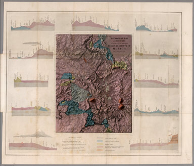
Full Title
Geological map and profiles of some of the principal mining districts of Mexico. Geographical Institute, Baron F.W. Von Egloffstein, No. 164 Broadway N. York. Lettering by Oliver J. Stuart, N.Y. Entered ... 1864, by F.W. von Egloffstein ... New York. Printed by W. Pate. (with) The Geological profiles. (to accompany) Contributions to the Geology and the Physical Geography of Mexico, including a Geological and Topographical Map ... 1864.
Publisher
D. Appleton & Company.
Author
Egloffstein, Baron F.W. von
Full Title
Geological map and profiles of some of the principal mining districts of Mexico. Geographical Institute, Baron F.W. Von Egloffstein, No. 164 Broadway N. York. Lettering by Oliver J. Stuart, N.Y. Entered ... 1864, by F.W. von Egloffstein ... New York. Printed by W. Pate. (with) The Geological profiles. (to accompany) Contributions to the Geology and the Physical Geography of Mexico, including a Geological and Topographical Map ... 1864.
Publisher
D. Appleton & Company.
Author
Duflot de Mofras, Eugene
Full Title
(Covers to Vol 1) Exploration Du Territoire De L'Oregon, Des Californies Et De La Mer Vermeille, Executee Pendant Les Annees 1840, 1841 Et 1842, Par M. Duflot De Mofras, Attache A La Legation De France A Mexico. Ouvrage Publie Par Ordre Du Roi, Sous Les Auspices De M. Le Marechal Soult, Duc De Dalmatie, President du Conseil, Et De M. Le Ministre Des Affaires Etrangeres. Tome Premier. Paris, Arthus Bertrand, Editeur, Libraire De La Societe De Geographie, Rue Hautefeuille, No. 23. 1844. Paris. - Typographie de Firmin Didot Freres, rue Jacob, 56 ... Tome Second ... Atlas (with map) Carte De La Cote De L'Amerique Sur L'Ocean Pacifique Septentrional comprenant Le Territoire De L'Oregon, Les Californies, La Mer Vermeille ...
Publisher
Arthus Bertrand
Author
Duflot de Mofras, Eugene
Full Title
(Title Page to Vol 1) Exploration Du Territoire De L'Oregon, Des Californies Et De La Mer Vermeille, Executee Pendant Les Annees 1840, 1841 Et 1842, Par M. Duflot De Mofras, Attache A La Legation De France A Mexico. Ouvrage Publie Par Ordre Du Roi, Sous Les Auspices De M. Le Marechal Soult, Duc De Dalmatie, President du Conseil, Et De M. Le Ministre Des Affaires Etrangeres. Tome Premier. Paris, Arthus Bertrand, Editeur, Libraire De La Societe De Geographie, Rue Hautefeuille, No. 23. 1844. Paris. - Typographie de Firmin Didot Freres, rue Jacob, 56 ... Tome Second ... Atlas (with map) Carte De La Cote De L'Amerique Sur L'Ocean Pacifique Septentrional comprenant Le Territoire De L'Oregon, Les Californies, La Mer Vermeille ...
Publisher
Arthus Bertrand
Author
Duflot de Mofras, Eugene
Full Title
Vue du Port De Monterey Capitale de la Nouvelle Californie.
Publisher
Arthus Bertrand
Author
Duflot de Mofras, Eugene
Full Title
Le R.P. Narcisco Duran, prefet apostolique des Franciscains Espagnole missionnaires dans la Nouvelle Californie
Publisher
Arthus Bertrand
Author
Duflot de Mofras, Eugene
Full Title
Ranchero Californien Jetant le Lazo.
Publisher
Arthus Bertrand
Author
Duflot de Mofras, Eugene
Full Title
Isba. Maison des Colonies de L'Amerique Russe.
Publisher
Arthus Bertrand
Author
Duflot de Mofras, Eugene
Full Title
(Covers to Vol 2) Exploration Du Territoire De L'Oregon, Des Californies Et De La Mer Vermeille, Executee Pendant Les Annees 1840, 1841 Et 1842, Par M. Duflot De Mofras, Attache A La Legation De France A Mexico. Ouvrage Publie Par Ordre Du Roi, Sous Les Auspices De M. Le Marechal Soult, Duc De Dalmatie, President du Conseil, Et De M. Le Ministre Des Affaires Etrangeres. Tome Premier. Paris, Arthus Bertrand, Editeur, Libraire De La Societe De Geographie, Rue Hautefeuille, No. 23. 1844. Paris. - Typographie de Firmin Didot Freres, rue Jacob, 56 ... Tome Second ... Atlas (with map) Carte De La Cote De L'Amerique Sur L'Ocean Pacifique Septentrional comprenant Le Territoire De L'Oregon, Les Californies, La Mer Vermeille ...
Publisher
Arthus Bertrand
Author
Duflot de Mofras, Eugene
Full Title
(Title Page to Vol 2) Exploration Du Territoire De L'Oregon, Des Californies Et De La Mer Vermeille, Executee Pendant Les Annees 1840, 1841 Et 1842, Par M. Duflot De Mofras, Attache A La Legation De France A Mexico. Ouvrage Publie Par Ordre Du Roi, Sous Les Auspices De M. Le Marechal Soult, Duc De Dalmatie, President du Conseil, Et De M. Le Ministre Des Affaires Etrangeres. Tome Premier. Paris, Arthus Bertrand, Editeur, Libraire De La Societe De Geographie, Rue Hautefeuille, No. 23. 1844. Paris. - Typographie de Firmin Didot Freres, rue Jacob, 56 ... Tome Second ... Atlas (with map) Carte De La Cote De L'Amerique Sur L'Ocean Pacifique Septentrional comprenant Le Territoire De L'Oregon, Les Californies, La Mer Vermeille ...
Publisher
Arthus Bertrand
Author
Duflot de Mofras, Eugene
Full Title
Indiens Kodiaks Chassant La Baleine.
Publisher
Arthus Bertrand
Author
Duflot de Mofras, Eugene
Full Title
Vue de la Nouvelle Archangel.
Publisher
Arthus Bertrand
Author
Duflot de Mofras, Eugene
Full Title
Temascal, Bain des Indiens.
Publisher
Arthus Bertrand
Author
Duflot de Mofras, Eugene
Full Title
Sculptures Indiennes, Cote Nord Ouest de L'Amerique.
Publisher
Arthus Bertrand
Author
[Butterfield, Carlos, Johnson & Browning]
Full Title
United States and Mexican Mail Steamship Line, and Statistics of Mexico. By Carlos Butterfield, Washington. December, 1859. New York: J.A.H. Hasbrouck & Co., Printers ... 1860. (on verso) Entered ... 1859, by Carlos Butterfield ... New York. (With) Map of the United States and Mexico Published by Johnson & Browning under the direction of Col. Carlos Butterfield. December 1859.
Publisher
J.A.H. Hasbrouck & Co.
Author
[Butterfield, Carlos, Johnson & Browning]
Full Title
(Title page to) United States and Mexican Mail Steamship Line, and Statistics of Mexico. By Carlos Butterfield, Washington. December, 1859. New York: J.A.H. Hasbrouck & Co., Printers ... 1860. (on verso) Entered ... 1859, by Carlos Butterfield ... New York. (With) Map of the United States and Mexico Published by Johnson & Browning under the direction of Col. Carlos Butterfield. December 1859.
Publisher
J.A.H. Hasbrouck & Co.
Author
Espinosa y Tello, J.
Full Title
Carta Esferica de los Reconocimientos Hechos en la Costa N.O. De America en 1791 y 92 por las Goletas Sutil y Mexicana, y otros Buques de S.M. Cardano lo grabo. Morata lo escribio. Numero 1.
Publisher
Imprenta Real
Author
Pike, Zebulon Montgomery
Full Title
(Title Page to) An Account of Expeditions to the Sources of the Mississippi, and Through the Western Parts of Louisiana, to the Sources of the Arkansaw, Kans, La Platte, and Pierre Jaun, Rivers; ... During the Years 1805, 1806, and 1807. And a Tour Through the Interior Parts of New Spain, When Conducted Through These Provinces, by order of The Captain-General, in the year 1807. By Major Z.M. Pike. Illustrated by Maps and Charts. Philadelphia: Published by C. & A. Conrad & Co. No. 30, Chesnut Street. Somervell & Conrad, Petersburgh. Bonsal, Conrad, & Co. Norfolk, and Fielding Lucas, Jr. Baltimore. John Binns, Printer....1810.
Publisher
C. & A. Conrad
Author
Pike, Zebulon Montgomery
Full Title
Falls of St. Anthony.
Publisher
C. & A. Conrad
Author
Pike, Zebulon Montgomery
Full Title
A Chart of the Internal Part of Louisiana, Including all the hitherto unexplored Countries, lying between the River La Platte of the Missouri on the N: and the Red River on the S: the Mississippi East and the Mountains of Mexico West; with a Part of New Mexico & the Province of Texas by Z.M. Pike Captn. U.S.I.
Publisher
C. & A. Conrad
Author
Pike, Zebulon Montgomery
Full Title
A Map of The Internal Provinces of New Spain. The Outlines are from the Sketches of but corrected and improved by Captain Zebulon M. Pike, who was conducted through that Country, in the Year 1807, by Order of the Commandant General of those Provinces.
Publisher
C. & A. Conrad
Author
Pike, Zebulon Montgomery
Full Title
A Sketch of the Vice Royalty Exhibiting the several Provinces and its Aproximation (sic) to the Internal Provinces of New Spain.
Publisher
C. & A. Conrad
1-45 of 45
|