Browse All

1844 Cover: Exploration du Territoire de L'Or … Exploration Book (Covers to) Exploration Du Territoire De … |

1844 Half Title: Exploration du Territoire de … Exploration Book (Half Title Page to) Exploration Du Terr … |

1844 Title Page: Exploration du Territoire de … Exploration Book (Title Page to) Exploration Du Territoir … |

1844 Index: Exploration du Territoire de l'Or … Exploration Book (Index to) Exploration Du Territoire De … |

1844 Carte De La Cote De L'Amerique. Exploration Book Carte De La Cote De L'Amerique Sur L'Oce … |

1844 Carte De L'Ocean Pacifique Au Nord De L' … Exploration Book Carte De L'Ocean Pacifique Au Nord De L' … |

1844 Isthme de Tehuantepec. Exploration Book Isthme de Tehuantepec. No. 3. Publie Par … |

1844 Plan Du Port Del Manzanillo. Exploration Book Plan Du Port Del Manzanillo Dans Le Terr … |

1844 Plan De Mazatlan. Exploration Book Plan De Mazatlan. No. 7. (with) Plan De … |

1844 Plan Du Port De Guaymas. Exploration Book Plan Du Port De Guaymas sur la Mer Verme … |

1844 Plan De L'Embouchure Du Rio Colorado. Exploration Book Plan De L'Embouchure Du Rio Colorado dan … |

1844 Mouillage De San Pedro. No. 12. (with) M … Exploration Book Mouillage De San Pedro. No. 12. (with) M … |

1844 Plan du Port Et De La Baie De Monte-Rey. Exploration Book Plan du Port Et De La Baie De Monte-Rey … |

1844 Port De San Francisco Dans La Haute Cali … Exploration Book Port De San Francisco Dans La Haute Cali … |

1844 Carte Detaillee Du Mouillage Du Fort Ros … Exploration Book Carte Detaillee Du Mouillage Du Fort Ros … |

1844 Rio Colombia. Exploration Book Carte Du Rio Colombia Depuis Son Embouch … |

1844 Port De Quadra ou De La Decouverte. Exploration Book Port De Quadra ou De La Decouverte. No. … |

1844 Port Du Port Mulgrave. Exploration Book Port Du Port Mulgrave. No. 22. Plan Du P … |

1844 Vue De La Mission De Saint Louis. Exploration Book Vue De La Mission De Saint Louis Roi De … |

1844 Plan Geometrique De La Mission De St. Lo … Exploration Book Plan Geometrique De La Mission De St. Lo … |

1844 Tete De Chef Indien De La Cote Nord Oues … Exploration Book Tete De Chef Indien De La Cote Nord Oues … |

1844 Cranes Des Indiens Tetes Plates De La Co … Exploration Book Cranes Des Indiens Tetes Plates De La Co … |

1848 Title Page: Notes of a military reconnoi … Exploration Book (Title Page to) Notes of a Military Reco … |

1848 Military Reconnaissance Of The Arkansas … Exploration Book Military Reconnaissance Of The Arkansas … |

1857 Map of the United States. Exploration Book Map Of The United States And Their Terri … |

1857 Title Page: Report on the United States … Exploration Book (Title Page to) Report on the United Sta … |

1845 Title Page: Report of the Exploring Expe … Exploration Book (Title Page to) Report of The Exploring … |

1845 Map Of An Exploring Expedition To The Ro … Exploration Book Map Of An Exploring Expedition To The Ro … |

1848 Title Page: Geographical memoir upon Upp … Exploration Book (Title Page to) Geographical Memoir upon … |
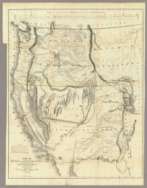
1848 Map Of Oregon And Upper California. Exploration Book Map Of Oregon And Upper California From … |

1869 Title Page: Geological report of the Exp … Exploration Book (Title Page to) Geological Report of the … |

1869 Map Of The Yellowstone And Missouri Rive … Exploration Book U.S. War Department Map Of The Yellowsto … |

1876 Title Page: Report of the Exploring Expe … Exploration Book (Title Page to) Report of the Exploring … |

1876 Map of Exploration and Surveys in New Me … Exploration Book Map of Exploration and Surveys in New Me … |

1865 Title Page: Miners and travelers' guide … Exploration Book (Title Page to) Miners and Travelers' Gu … |

1879 Cover: Topographical, geological atlas, … [Exploration Book, State Atlas] (covers to) Topographical and geological … |

1879 Title Page: Topographical and geological … [Exploration Book, State Atlas] (Title Page to) Topographical and geolog … |

1879 Map of the district of the High Plateaus … [Exploration Book, State Atlas] Map of the district of the High Plateaus … |

1879 Geological map of the district of the hi … [Exploration Book, State Atlas] Geological map of the district of the hi … |

1879 Relief map of the district of the high p … [Exploration Book, State Atlas] Relief map of the district of the high p … |

1879 Map of portions of Utah and Arizona show … [Exploration Book, State Atlas] Map of portions of Utah and Arizona show … |

1879 Stereogram of displacements in the distr … [Exploration Book, State Atlas] Stereogram of displacements in the distr … |

1879 Structure sections through the high plat … [Exploration Book, State Atlas] Structure sections through the high plat … |

1879 Structure sections through the high plat … [Exploration Book, State Atlas] Structure sections through the high plat … |

1879 Map of Utah Territory. [Exploration Book, State Atlas] Map of Utah Territory compiled and drawn … |

1865 General Map of the North Pacific States … Exploration Book General Map of the North Pacific States … |

1843 Title Page: Report intended to illustrat … Exploration Book (Title Page to) Report Intended To Illus … |

1843 Hydrographical Basin of the Upper Missis … Exploration Book Hydrographical Basin of the Upper Missis … |

1859 Covers: Hand Book to Kansas Territory An … Exploration Book (Covers to) Hand Book To Kansas Territor … |

1859 Catalog: Hand Book to Kansas Territory A … Exploration Book Catalog) Hand Book To Kansas Territory A … |