Browse All

1952 Italia. Piedmonte, Valle d'Aosta. Liguri … World Atlas Italia. Piedmonte, Valle d'Aosta. Liguri … |

1952 Italia. Trentino-Alto Arige. Venezia. Em … World Atlas Italia. Trentino-Alto Arige. Venezia. It … |

1964 Text Page: The Use Of Our Forests State Atlas (Text Page to) 28. The Use Of Our Forest … |

1953 Conservation of Resources. World Atlas Conservation of Resources. |

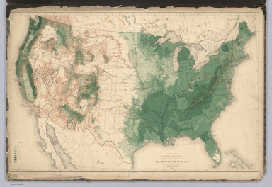
1884 Position of the Forest, Prairie and Tree … Physical Atlas Map Showing the Position of the Forest, … |

1884 Natural Divisions of the North American … Physical Atlas Map Showing the Natural Divisions of the … |

1884 Distribution of Genus Fraxinus [The Ashe … Physical Atlas Map Showing the Distribution of Genus Fr … |

1884 Distribution of the Genera Carya & Umbel … Physical Atlas Map Showing the Distribution of the Gene … |

1884 Distribution of the Genus Juglans [The W … Physical Atlas Map Showing the Distribution of the Genu … |

1884 Distribution of the Genus Quercus [The O … Physical Atlas Map Showing the Distribution of the Genu … |

1884 Distribution of the Genera Castanea & Ca … Physical Atlas Map Showing the Distribution of the Gene … |

1884 Distribution of the Genus Pinus [The Pin … Physical Atlas Map Showing the Distribution of the Genu … |

1884 Distribution of the Genus Abies & Picea … Physical Atlas Map Showing the Distribution of the Genu … |

1884 Distribution of Liriodendron Tulipifera … Physical Atlas Map Showing the Distribution of Lirioden … |

1884 Distribution of Prosopsis Juliflora, Que … Physical Atlas Map Showing the Distribution of Prosopsi … |

1884 Distribution of Fraxinus Americana & Pin … Physical Atlas Map Showing the Distribution of Fraxinus … |

1884 Distribution of the Genera Chamaecyparis … Physical Atlas Map Showing the Distribution of the Gene … |

1884 Distribution of the Genera Thuya, Taxodi … Physical Atlas Map Showing the Distribution of the Gene … |

1884 Distribution of Pinus Strobus, P. (Pinus … Physical Atlas Map Showing the Distribution of Pinus St … |
1884 United States showing the Relative Avera … Physical Atlas Map of the United States showing the Rel … |

1877 Text Page: Trees in New Hampshire. State Atlas (Text Page) The Distribution of Trees in … |

1877 Text Page: Trees in New Hampshire (concl … State Atlas (Text Page) The Distribution of Trees in … |

1877 Trees in New Hampshire. Agriculture in N … State Atlas Map Illustrating the Distribution of Tre … |

1966 Forests. National Atlas Forests. |

1906 No. 8, Forests National Atlas Department of Interior : Atlas of Canada … |

1906 No. 9, Limit of forest trees National Atlas Department of Interior : Atlas of Canada … |

1915 Forests National Atlas Forests. Revised by Forestry Branch. (on … |

1915 Limits of forest trees National Atlas Limits of forest trees. (on upper margin … |

1907 Timber - Growing Countries Statistical Atlas Timber - Growing Countries |

1900 View: Plate XXXVI. Tatoosh Range; Mount … [Geologic Atlas, Geology Book] (View) Plate XXXVI. A. Tatoosh Range; Mo … |

1900 Plate XXXVII. Mount Rainier Forest Reser … [Geologic Atlas, Geology Book] Plate XXXVII. Mount Rainier Forest Reser … |

1900 View: Plate XXXVIII. Tree Part Closeups. [Geologic Atlas, Geology Book] (View) Plate XXXVIII. A. Tsuga pattonian … |

1900 Plate XXXIX. Mount Rainier Forest Reserv … [Geologic Atlas, Geology Book] Plate XXXIX. Mount Rainier Forest Reserv … |

1900 View: Plate XL. Tree Part Closeups. [Geologic Atlas, Geology Book] (View) Plate XL. A. Larix occidentalis. … |

1900 Diagram: Plate XLI. Diagram Showing Rang … [Geologic Atlas, Geology Book] (Diagram) Plate XLI. Diagram Showing Ran … |

1900 Plate XLII. Mount Rainier Forest Reserve … [Geologic Atlas, Geology Book] Plate XLII. Mount Rainier Forest Reserve … |

1900 View: Plate XLIII. Pines, and Red Fir in … [Geologic Atlas, Geology Book] (View) Plate XLIII. A. Pines and Red Fir … |

1900 View: Plate XLIV. Maple Grove. Yellow Fi … [Geologic Atlas, Geology Book] (View) Plate XLIV. A. Maple Grove. B. Ye … |

1900 View: Plate XLV. Fir, Maple and Ash Tree … [Geologic Atlas, Geology Book] (View) Plate XLV. A. Fir, Maple and Ash … |

1900 Plate XLVI. Mount Rainier Forest Reserve … [Geologic Atlas, Geology Book] Plate XLVI. Mount Rainier Forest Reserve … |

1900 View: Plate XLVII. Mount Rainier from Go … [Geologic Atlas, Geology Book] (View) Plate XLVII. A. Mount Rainier fro … |

1900 View: Plate XLVIII. Summit of Range. Hea … [Geologic Atlas, Geology Book] (View) Plate XLVIII. A. Summit of Range … |

1900 View: Plate XLIX. Mount Adams. Cispus Ra … [Geologic Atlas, Geology Book] (View) Plate XLIX. A. Mount Adams. B. Ci … |

1900 View: Plate L. Recent Cinder Cone, Mount … [Geologic Atlas, Geology Book] (View) Plate L. A. Recent Cinder Cone on … |

1899 Plate LI. Land Classification in Olympic … [Geologic Atlas, Geology Book] Plate LI. Part of the Olympic Forest Res … |

1900 View: Plate LII. View of Head of Lillian … [Geologic Atlas, Geology Book] (View) Plate LII. A. View of Head of Lil … |

1899 Plate LIII. Land Classification in Olymp … [Geologic Atlas, Geology Book] Plate LIII. Part of the Olympic Forest R … |

1900 View: Plate LIV. Quillayute Prairie. Ced … [Geologic Atlas, Geology Book] (View) Plate LIV. A. Quillayute Prairie. … |

1900 View: Plate LV. Spruce near Lake Ozette. … [Geologic Atlas, Geology Book] (View) Plate LV. A. Spruce near Lake Oze … |

1899 Plate LVI. Part of the Olympic Forest Re … [Geologic Atlas, Geology Book] Plate LVI. Part of the Olympic Forest Re … |