Who What Where WhenREMOVE |
REFINE
Browse All : Geography Book and Book Map of United States
1-8 of 8
Author
[Pownall, Thomas, 1722-1805, Evans, Lewis, 1700?-1756, Almon, John, 1737-1805, Turner, James, d. 1759, Gist, Christopher, d. 1750]
Full Title
A Map of the Middle British Colonies in North America. First Published by Mr. Lewis Evans, of Philadelphia, in 1755; and since corrected and improved, as also extended with the addition of New England, and bordering Parts of Canada; from actual Surveys now lying at the Board of trade. By T. Pownall MP. Engraved by Jas. Turner in Philadelphia.
Publisher
John Almon
Author
Jefferys, Thomas
Full Title
A map of Canada and the north part of Louisiana with the adjacent countrys. By Thos. Jefferys, Geographer to His Royal Highness the Prince of Wales. T. Jefferys sculp. (1760)
Publisher
Thomas Jefferys
Author
[Anville, Jean Baptiste Bourguignon d, 1697-1782, Jefferys, Thomas]
Full Title
North America from the French of Mr. d'Anville, improved with the back settlements of Virginia and course of Ohio. Illustrated with geographical and historical remarks. 1755 published according to Act by Thos. Jefferys Geographer to His Royal Highness the Prince of Wales near Charing Cross. (1760)
Publisher
Thomas Jefferys
Author
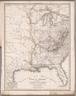
[Poirson, J.B., Herbin de Halle, Etienne de.]
Full Title
Cours du Mississippi comprenant la Louisiane, les 2 Florides, une partie des Etats-Unis et pays adjacents. Par J. B. Poirson, ingenieur geographe ; Nivose An XI (1803), grave par Tardieu l'aine rue de Sorbonne, no. 385. (on upper right margin) No.XVIII. (to accompany) Statistique Generale et Particuliere De La France et De Ses Colonies, avec une Nouvelle Description ... 1804.
Publisher
F. Buisson
Author
Gilpin, William
Full Title
Map Illustrating the System of the Parcs, and the Domestic Relations of the "Great Plains," the "North American Andes," and the Pacific Maritime Front."
Publisher
J.B. Lippincott & Co.
Author
Tanner, Henry S.
Full Title
A Connected View of The Whole Internal Navigation of the United States; ... Corrected and Improved From the Edition of 1826, And Much Enlarged, ... With A Sheet Map, ... The Map Has Been Engraved For the Purpose ... On A Reduced Scale, From Tanner's Excellent Four Sheet Map of the United States, Recently Published. ... By a Citizen of the United States. Philadelphia: Published by the Author ... Printed by Lydia R. Bailey. 1830. (on verso) ...on the seventeenth day of April ... 1830, George Armroyd ... hath deposited ... a Book ... Pennsylvania.
Publisher
George Armroyd
Author
[Mitchell, John, Raynal, G.T., Zatta, Antonio]
Full Title
Il Canada, Le Colonie Inglesi Con La Luigiana, e Florida. di nuova Projezione. Venezia 1778. Presso Antonio Zatta Con Privilegio dell'Eccmo Senato. G. Zuliani inc.
Publisher
Antonio Zatta
1-8 of 8
|